more stats
1.2 miles
Distance
386 ft
Climb
-234 ft
Descent
00:13:46
Avg time
154 ft
Altitude change
1,663 ft
Altitude min
1,844 ft
Altitude max
1,663 ft
Altitude start
1,818 ft
Altitude end
2.5%
Grade
-39.4%
Grade max
41.3%
Grade min
3,642 ft
Distance climb
1,913 ft
Distance down
554 ft
Distance flat
00:13:46
Avg time

Anonymous Details

  • Activities
    • Mountain Bike
    • E-Bike
    • Adaptive Bike
  • Riding Area
    Jubilee Park
    Toowoomba
  • Difficulty Rating
  • Local Popularity
    90 in Mountain Biking [+]
    • 80 in E-Biking
  • Global Ranking
    #28303 in Mountain Biking [+]
    • #33317 in E-Biking
  • Trail Type
    Singletrack
  • Bike Type
  • Direction
    Both Directions
  • Climb Difficulty
    Green
  • Physical Rating
    Easy
  • Family Friendly
    Yes
  • Dogs Allowed
    Yes
  • eBike Allowed
    Yes up to Class 1
  • TTFs on Trail
    Berm
  • Year Opened
    2017

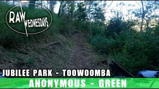
Anonymous was a crowded funded trail and provides an alternative easier trail to access the lower trails. An honour board recognising those who financially contributed is located along the trail. There are several options to make loops back with Hyperlink.

Adaptive Bike Info
aMTB Blue Rating: Intermediate features and steeper terrain.

There's a log in the middle that is a bit off camber and possible to get stuck on. A couple of tight corners too

Trail Supporters
Local Trail Association
Traditionally Indigenous Territory

Recent Activity on Trail

Past Week
  • 1 rides
  • 8 miles average
6 Months
  • 25 rides
  • 13 miles avg distance
All
  • 491 rides
  • Last: Jun 27, 2026
c1c2c3c4
January
February
March
April
May
June
July
August
September
October
November
December
Status:
on Apr 18, 2026
Very Dry
Avg: 4.06 (8 votes)
Your vote: 0

view (7,758)
close
3D
Trail Conditions
  • Unknown
  • Snow Groomed
  • Snow Packed
  • Snow Covered
  • Snow Cover Partial
  • Freeze/thaw Cycle
  • Icy
  • Prevalent Mud
  • Wet
  • Variable
  • Ideal
  • Dry
  • Very Dry
Trail Flow (Ridden Direction)
Trailforks scans users ridelogs to determine the most popular direction each trail is ridden. A good flowing trail network will have most trails flowing in a single direction according to their intension.
The colour categories are based on what percentage of riders are riding a trail in its intended direction.
  • > 96%
  • > 90%
  • > 80%
  • > 70%
  • > 50%
  • < 50%
  • bi-directional trail
  • no data
Trail Last Ridden
Trailforks scans ridelogs to determine the last time a trail was ridden.
  • < 2 days
  • < 1 week
  • < 2 weeks
  • < 1 month
  • < 6 months
  • > 6 months
Trail Ridden Direction
The intended direction a trail should be ridden.
  • Downhill Only
  • Downhill Primary
  • Both Directions
  • Uphill Primary
  • Uphill Only
  • One Direction
Contribute Details
Colors indicate trail is missing specified detail.
  • Description
  • Photos
  • Description & Photos
  • Videos
Trail Popularity ?
Trailforks scans ridelogs to determine which trails are ridden the most in the last 9 months. Trails are compared with nearby trails in the same city region with a possible 25 colour shades. Think of this as a heatmap, more rides = more kinetic energy = warmer colors.
  • most popular
  • popular
  • less popular
  • not popular
ATV/ORV/OHV Filter
Max Vehicle Width
inches
US Cell Coverage
Legend
cell carrier legend

Radar Time
Activity Recordings
Trailforks uses anonymized public activity data. ?
Activity Recordings
Trailforks uses anonymized public activity data. ?
Personal Heatmap
Activity Types
all / none
Options
2
Date range month
Winter Trails
Warning A routing network for winter maps does not exist. Selecting trails using the winter trails layer has been disabled.
Missing Trails
Most Popular
Least Popular
Trails are colored based on popularity. The more popular a trail is, the more red. Less popular trails trend towards green.
Jump Magnitude Heatmap
Heatmap of where riders jump on trails. Zoom in to see individual jumps, click circles to view jump details.
BC Backroad Status

Service Road Atlas is a free to use, community-driven service for viewing and creating reports on the numerous back-country service roads around B.C. and Alberta.

map legend
Slope Aspect
Direction the slope faces
Flat N NE E SE S SW W NW
Trails Deemphasized
Trails are shown in grey.
disable
Only show trails with no bike usage.
Enable
Suggested Layers
Based on selected activity type

    Save the current map location and zoom level as your default home location whenever this page is loaded.

    Save
        Directions to anonymous trailhead (-27.539970, 151.984680)

        Photos

        13 more »
        56 |
        Aug 29, 2020 @ 2:45pm
        Aug 29, 2020
        54 |
        Aug 29, 2020 @ 2:44pm
        Aug 29, 2020
        59 |
        Aug 29, 2020 @ 2:44pm
        Aug 29, 2020
        73 |
        Jan 5, 2020 @ 1:22pm
        Jan 5, 2020

        Videos

        7 more »
        youtuber Ride Guide! | Jubilee Park Toowoomba
        19:08 | 392 | Oct 23, 2024 , Toowoomba
        Jubilee Park Toowoomba MTB Trails - Anonymous
        8:25 | 73 | Aug 6, 2024 , Toowoomba
        youtuber ANONYMOUS | Jubilee Park | RAW WEDNESDAYS
        7:01 | 188 | Sep 30, 2022 , Toowoomba
        youtuber Jubilee Park top to bottom TWICE | RAW FULL RUN
        39:26 | 194 | Mar 21, 2022 , Toowoomba

        Routes with this trail

        7 miles 1,970 ft 9
        Do this route starting at the bottom for the ultimate jubilee experience
        13 miles 2,760 ft 65 Race
        Queensland Enduro Series round 2 Jubilee
        3.0 7 miles 1,192 ft 21 Race
        Range8 is Toowoomba Mountain Bike Club event, racing the best single track Toowoomba's Jubilee Park has to...

        Reviews / Comments

        No reviews yet, be the first to write a review or ask a question.
        Use trail reports to comment on trail conditions.


        We hope you've been enjoying Trailforks!

        Create a FREE account to view trail comments and much more.

        • By Rodhickey & contributors
        • #82180 - 2,437 views

        Frequently Asked Questions About Anonymous

        Where is Anonymous located?
        Anonymous is located in Jubilee Park, Toowoomba, Australia. It is part of the Jubilee Park trail network. The trailhead is located at coordinates -27.53997, 151.98468.
        How hard is Anonymous?
        Anonymous is rated as Green difficulty. The physical rating is Easy. The average grade is 2.5%. The climb difficulty is rated Green.
        What is the elevation gain for Anonymous?
        Anonymous has 386 ft of elevation gain. The trail has 234 ft of elevation descent. The elevation ranges from 1,663 ft to 1,844 ft.
        Is Anonymous a point to point trail?
        Anonymous is not a point to point trail. The direction is Both Directions. The trail type is singletrack.

        Hit the Trail

        Open in App

        Get this trail on your phone instantly.
        open trail in app

        Download Trail

        Save to wishlist, Garmin & download.
        save the trail

        Find Related Routes

        Find routes and users activities that include this trail.
        find routes for this trail

        You must enter a description before submitting.