more stats
1.7 miles
Distance
497 ft
Climb
00:24:51
Avg time
497 ft
Altitude change
8,771 ft
Altitude min
9,267 ft
Altitude max
8,771 ft
Altitude start
9,268 ft
Altitude end
5.5%
Grade
0.5%
Grade max
26.3%
Grade min
2 miles
Distance climb
13 ft
Distance down
20 ft
Distance flat
00:24:51
Avg time

Apex Details

  • Activities
    • Mountain Bike
    • Adaptive Bike
    • Hike
    • Trail Running
  • Riding Area
    Park City Mountain Resort
    Park City, Utah
  • Difficulty Rating
  • Local Popularity
    45 in Mountain Biking [+]
    • 25 in Trail Running
    • 20 in Hiking
  • Global Ranking
    #101390 in Mountain Biking [+]
    • #127191 in Trail Running
    • #121373 in Hiking
  • Hiking SAC Scale
    T2 Mountain Hiking
  • Trail Type
    Singletrack
  • Bike Type
    AM, XC, Adaptive MTB
  • Direction
    Both Directions
    Popular In Reverse
  • Climb Difficulty
    Green
  • Physical Rating
    Moderate
  • Dogs Allowed
    Yes

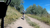
This really is a great climbing trail. Not too difficult, and a lot of the trail is deep through the trees with widened turns so that you can keep your uphill cadence consistent. This trail is commonly used as a climbing trail to get to some of the better downhill oriented trails.

Adaptive Bike Info
aMTB Blue Rating: Intermediate features and steeper terrain.

Only applies to upper portion of trail.

Tread width is 12 to 22 inches wide. I’m pretty sure that I never had all three wheels on the trail surface! Mostly on camber, some bench hill riding, One or two spots with some mild exposure.

There is a 29 inch wide gap between two trees. Not possible with a wider bike.

Local Trail Association

Recent Activity on Trail

Past Week
  • 1 rides
  • 13 miles average
6 Months
  • 6 rides
  • 25 miles avg distance
All
  • 182 rides
  • Last: Jun 28, 2026
c1c2c3c4
January
February
March
April
May
June
July
August
September
October
November
December
update trails status or condition

Apex Trail Reports

statusdatedescription
Oct 2, 2025 @ 12:31pm (America/Denver)
Oct 2, 2025
great dirt, no dust after .5" last night. Leaves colors are stunning
Aug 31, 2025 @ 2:31pm
Aug 31, 2025
Bone dry but not loose yet after the rain this week
Jun 24, 2025 @ 2:42pm
Jun 24, 2025
Aug 23, 2024 @ 9:07am
Aug 23, 2024
Jul 10, 2024 @ 4:11am
Jul 10, 2024
more »
Status:
on Oct 2, 2025
Ideal
Avg: 3.95 (14 votes)
Your vote: 0

view (1,068)
close
3D
Trail Conditions
  • Unknown
  • Snow Groomed
  • Snow Packed
  • Snow Covered
  • Snow Cover Partial
  • Freeze/thaw Cycle
  • Icy
  • Prevalent Mud
  • Wet
  • Variable
  • Ideal
  • Dry
  • Very Dry
Trail Flow (Ridden Direction)
Trailforks scans users ridelogs to determine the most popular direction each trail is ridden. A good flowing trail network will have most trails flowing in a single direction according to their intension.
The colour categories are based on what percentage of riders are riding a trail in its intended direction.
  • > 96%
  • > 90%
  • > 80%
  • > 70%
  • > 50%
  • < 50%
  • bi-directional trail
  • no data
Trail Last Ridden
Trailforks scans ridelogs to determine the last time a trail was ridden.
  • < 2 days
  • < 1 week
  • < 2 weeks
  • < 1 month
  • < 6 months
  • > 6 months
Trail Ridden Direction
The intended direction a trail should be ridden.
  • Downhill Only
  • Downhill Primary
  • Both Directions
  • Uphill Primary
  • Uphill Only
  • One Direction
Contribute Details
Colors indicate trail is missing specified detail.
  • Description
  • Photos
  • Description & Photos
  • Videos
Trail Popularity ?
Trailforks scans ridelogs to determine which trails are ridden the most in the last 9 months. Trails are compared with nearby trails in the same city region with a possible 25 colour shades. Think of this as a heatmap, more rides = more kinetic energy = warmer colors.
  • most popular
  • popular
  • less popular
  • not popular
ATV/ORV/OHV Filter
Max Vehicle Width
inches
US Cell Coverage
Legend
cell carrier legend

Radar Time
Activity Recordings
Trailforks uses anonymized public activity data. ?
Activity Recordings
Trailforks uses anonymized public activity data. ?
Personal Heatmap
Activity Types
all / none
Options
2
Date range month
–
Winter Trails
Warning A routing network for winter maps does not exist. Selecting trails using the winter trails layer has been disabled.
Missing Trails
Most Popular
Least Popular
Trails are colored based on popularity. The more popular a trail is, the more red. Less popular trails trend towards green.
Jump Magnitude Heatmap
Heatmap of where riders jump on trails. Zoom in to see individual jumps, click circles to view jump details.
BC Backroad Status

Service Road Atlas is a free to use, community-driven service for viewing and creating reports on the numerous back-country service roads around B.C. and Alberta.

map legend
Slope Aspect
Direction the slope faces
Flat N NE E SE S SW W NW
Trails Deemphasized
Trails are shown in grey.
disable
Only show trails with no bike usage.
Enable
Suggested Layers
Based on selected activity type

    Save the current map location and zoom level as your default home location whenever this page is loaded.

    Save
        Directions to apex trailhead (40.633560, -111.529310)

        Photos

        23 more »
        60 |
        Sep 27, 2023 @ 11:38am
        Sep 27, 2023
        33 |
        Sep 9, 2023 @ 6:43am
        Sep 9, 2023
        48 |
        Oct 9, 2022 @ 11:35am
        Oct 9, 2022
        44 |
        Oct 9, 2022 @ 11:35am
        Oct 9, 2022

        Videos

        1 more »
        Park City P2P Chasing Alex
        0:16 | 180 | Mar 3, 2015 , Park City

        Trail Lists

        Routes with this trail

        14 miles 2,797 ft 7 Loop
        This route starts from Big Cottonwood near Guardsman Pass, but at the . It takes Blazing Saddle to Apex...
        18 miles 3,366 ft 9 Loop
        Climb from PCMR lot to 9K trail to descend , , and .
        39 miles 6,217 ft 12
        Ride from the Dutch Hollow trail system up WOW and to the mid-mountain trail to the Canyons.

        2 Reviews & Comments


        We hope you've been enjoying Trailforks!

        Create a FREE account to view trail comments and much more.

        • By toddTF Pro Trailforks & contributors
        • #11256 - 4,342 views

        Frequently Asked Questions About Apex

        Where is Apex located?
        Apex is located in Park City Mountain Resort, Park City, Utah, United States. It is part of the Park City Mountain Resort trail network. The trailhead is located at coordinates 40.63356, -111.52931.
        How hard is Apex?
        Apex is rated as Blue difficulty. The physical rating is Moderate. The average grade is 5.5%. The climb difficulty is rated Green.
        What is the elevation gain for Apex?
        Apex has 497 ft of elevation gain. The elevation ranges from 8,771 ft to 9,267 ft.
        Is Apex a point to point trail?
        Apex is not a point to point trail. The direction is Both Directions. The trail type is singletrack.

        Hit the Trail

        Open in App

        Get this trail on your phone instantly.
        open trail in app

        Download Trail

        Save to wishlist, Garmin & download.
        save the trail

        Find Related Routes

        Find routes and users activities that include this trail.
        find routes for this trail

        You must enter a description before submitting.