
Open in App
Get this trail on your phone instantly.

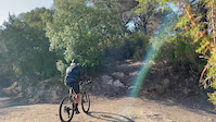
Sender que comença pujant un esglaó i per un sender fins al cim de la Muntanyeta de Ca n'Arnella. Baixada una mica tècnica, que segueix per un camí ample i acaba travessant un petit torrent.
ESP: Sendero que empieza subiendo un escalón y por un sendero hasta la cima de la Muntanyeta de Ca n'Arnella. Bajada algo técnica, que sigue por un camino ancho y acaba atravesando un pequeño torrente.
ENG: Trail that starts by going up a step and along a path to the top of Muntanyeta de Ca n'Arnella. A slightly technical descent, which follows a wide path and ends up crossing a small stream.
| c1 | c2 | c3 | c4 |
|---|---|---|---|
January | February | March | April |
May | June | July | August |
September | October | November | December |

Service Road Atlas is a free to use, community-driven service for viewing and creating reports on the numerous back-country service roads around B.C. and Alberta.
Save the current map location and zoom level as your default home location whenever this page is loaded.
Save
No reviews yet, be the first to write a review or ask a question.
Use trail reports to comment on trail conditions.
We hope you've been enjoying Trailforks!
Create a FREE account to view trail comments and much more.
You must enter a description before submitting.

