more stats
5,230 ft
Distance
-1,153 ft
Descent
00:10:07
Avg time
-1,153 ft
Altitude change
794 ft
Altitude min
1,947 ft
Altitude max
1,947 ft
Altitude start
794 ft
Altitude end
-22%
Grade
-66.9%
Grade max
3.6%
Grade min
56 ft
Distance climb
5,174 ft
Distance down
00:10:07
Avg time

Askati Details

  • Activities
    • Mountain Bike
    • E-Bike
    • Hike
    • Trail Running
  • Riding Area
    Bera/Lesaka
    Lesaka
  • Difficulty Rating
  • Voted Difficulty
    Black (5 votes)
  • Local Popularity
    95 in Mountain Biking [+]
    • 100 in E-Biking
    • 5 in Trail Running
    • 5 in Hiking
  • Global Ranking
    #1455 in Mountain Biking [+]
    • #5248 in E-Biking
    • #139742 in Trail Running
    • #684 in Hiking
  • Hiking SAC Scale
    T1 Hiking
  • Trail Type
    Singletrack
  • Bike Type
    DH, AM
  • Direction
    Downhill Only
    Popular Direction Shown
  • Climb Difficulty
    Blue
  • Physical Rating
    Moderate
  • Trail Visibility
    Always easy to follow
  • Dogs Allowed
    Yes
  • eBike Allowed
    Yes up to Class 1
  • TTFs on Trail
    Berm, Drop, Jump, Rock Face
  • Year Opened
    2023

(cast. abajo)
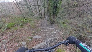
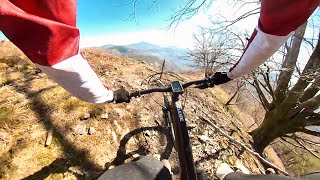
Kontuz seinalizazio gabeko bidea. Bizibideko jeitsierarik berriena, Orbeak emandako dirulaguntza batekin eraikia. Maila ertain-altuko jeitsiera. Lesakako ikuspegi ederra duen kresta malkartsu batetan hasten da. Horren ostean, zuhaitz tartera sartu eta modu errazean sahiesten ahal diren saltoak dituen zati batetik jeisten da. Erreka inguruan trialera batzuek zailtasun puntua igotzen dute. Lokatza dagoen egunetan zailtasun-maila igo daiteke gune honetan. Azken zatian errezagoa bihurtzen da eta “flow”a da nagusi.

---------------

Cuidado, bajada sin señalizar. Es la bajada más nueva de Bizibide, creada con una subvención proporcionada por Orbea. Bajada de nivel medio-alto. Salida en una cresta inclinada con espectaculares vistas de Lesaka a la que le sucede un tramo arbolado sin mayores dificultades técnicas y con saltos evitables. En una sección próxima a la regata las dificultades aumentan y varias trialeras pondrán a prueba las habilidades de los riders. La dificultad de esta zona puede verse incrementada los días de barro. Finalmente una zona más asequible y con mucho “flow” nos dejará un buen sabor de boca.

source: Web Askati
Local Trail Association

Recent Activity on Trail

Past Week
  • 0 rides
  •  
6 Months
  • 33 rides
  • 16 miles avg distance
All
  • 132 rides
  • Last: Jun 14, 2026
c1c2c3c4
January
February
March
April
May
June
July
August
September
October
November
December
Status:
on Jun 6, 2026
Ideal
Avg: 4.42 (15 votes)
Your vote: 0

view (584)
close
3D
Trail Conditions
  • Unknown
  • Snow Groomed
  • Snow Packed
  • Snow Covered
  • Snow Cover Partial
  • Freeze/thaw Cycle
  • Icy
  • Prevalent Mud
  • Wet
  • Variable
  • Ideal
  • Dry
  • Very Dry
Trail Flow (Ridden Direction)
Trailforks scans users ridelogs to determine the most popular direction each trail is ridden. A good flowing trail network will have most trails flowing in a single direction according to their intension.
The colour categories are based on what percentage of riders are riding a trail in its intended direction.
  • > 96%
  • > 90%
  • > 80%
  • > 70%
  • > 50%
  • < 50%
  • bi-directional trail
  • no data
Trail Last Ridden
Trailforks scans ridelogs to determine the last time a trail was ridden.
  • < 2 days
  • < 1 week
  • < 2 weeks
  • < 1 month
  • < 6 months
  • > 6 months
Trail Ridden Direction
The intended direction a trail should be ridden.
  • Downhill Only
  • Downhill Primary
  • Both Directions
  • Uphill Primary
  • Uphill Only
  • One Direction
Contribute Details
Colors indicate trail is missing specified detail.
  • Description
  • Photos
  • Description & Photos
  • Videos
Trail Popularity ?
Trailforks scans ridelogs to determine which trails are ridden the most in the last 9 months. Trails are compared with nearby trails in the same city region with a possible 25 colour shades. Think of this as a heatmap, more rides = more kinetic energy = warmer colors.
  • most popular
  • popular
  • less popular
  • not popular
ATV/ORV/OHV Filter
Max Vehicle Width
inches
US Cell Coverage
Legend
cell carrier legend

Radar Time
Activity Recordings
Trailforks uses anonymized public activity data. ?
Activity Recordings
Trailforks uses anonymized public activity data. ?
Personal Heatmap
Activity Types
all / none
Options
2
Date range month
Winter Trails
Warning A routing network for winter maps does not exist. Selecting trails using the winter trails layer has been disabled.
Missing Trails
Most Popular
Least Popular
Trails are colored based on popularity. The more popular a trail is, the more red. Less popular trails trend towards green.
Jump Magnitude Heatmap
Heatmap of where riders jump on trails. Zoom in to see individual jumps, click circles to view jump details.
BC Backroad Status

Service Road Atlas is a free to use, community-driven service for viewing and creating reports on the numerous back-country service roads around B.C. and Alberta.

map legend
Slope Aspect
Direction the slope faces
Flat N NE E SE S SW W NW
Trails Deemphasized
Trails are shown in grey.
disable
Only show trails with no bike usage.
Enable
Suggested Layers
Based on selected activity type

    Save the current map location and zoom level as your default home location whenever this page is loaded.

    Save
        Directions to askati trailhead (43.247310, -1.759600)

        Photos

        30 more »
        92 |
        Jan 4, 2025 @ 11:40am
        Jan 4, 2025
        147 |
        May 1, 2023 @ 4:13am
        May 1, 2023
        170 |
        May 1, 2023 @ 4:13am
        May 1, 2023
        38 |
        Jan 4, 2025 @ 11:41am
        Jan 4, 2025

        Videos

        2 more »
        Lesaka - Askati - MTB POV
        5:10 | 89 | Jan 4, 2026 , Lesaka
        ASKATI Enduro Lesaka
        6:08 | 114 | May 8, 2025 , Lesaka

        Routes with this trail

        14 miles 4,430 ft 10 Loop
        Track basado en la carrera del Open Sustrails 2024, celebrada en el mes de mayo de 2024. Aparcamos en las...

        Trail Events

        Links

        4 Reviews & Comments


        We hope you've been enjoying Trailforks!

        Create a FREE account to view trail comments and much more.

        • By ZumaiTxopeTF Pro & contributors
        • #619095 - 2,088 views

        Frequently Asked Questions About Askati

        Where is Askati located?
        Askati is located in Bera/Lesaka, Lesaka, Spain. It is part of the Bera/Lesaka trail network. The trailhead is located at coordinates 43.24731, -1.7596.
        How hard is Askati?
        Askati is rated as Black difficulty. The physical rating is Moderate. The average grade is 22%. The climb difficulty is rated Blue.
        What is the elevation gain for Askati?
        The trail has 1,153 ft of elevation descent. The elevation ranges from 794 ft to 1,947 ft.
        Is Askati a point to point trail?
        Yes, Askati is a point to point trail. The direction is Downhill Only. The trail type is singletrack.

        Hit the Trail

        Open in App

        Get this trail on your phone instantly.
        open trail in app

        Download Trail

        Save to wishlist, Garmin & download.
        save the trail

        Find Related Routes

        Find routes and users activities that include this trail.
        find routes for this trail

        You must enter a description before submitting.