more stats
3,484 ft
Distance
-549 ft
Descent
00:05:15
Avg time
-549 ft
Altitude change
4,953 ft
Altitude min
5,502 ft
Altitude max
5,502 ft
Altitude start
4,954 ft
Altitude end
-15.7%
Grade
-37%
Grade max
-4.7%
Grade min
3,484 ft
Distance down
00:05:15
Avg time

Avalancha Details

  • Activities
    • Mountain Bike
    • E-Bike
  • Riding Area
    Manzaneda Bike Park
    Pobra De Trives
  • Difficulty Rating
  • Local Popularity
    80 in Mountain Biking [+]
    • 90 in E-Biking
  • Global Ranking
    #75375 in Mountain Biking [+]
    • #16813 in E-Biking
  • Trail Type
    Singletrack
  • Bike Type
    DH, AM
  • Direction
    Downhill Only
    Popular Direction Shown
  • eBike Allowed
    Yes up to Class 1
  • TTFs on Trail
    Drop, Jump, Rock Garden

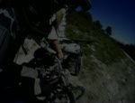
En esta pista mantenemos el nivel de dificultad de Carqueixa con algún que otro salto artificial, pasos por bosque con curvas muy bien dibujadas y terreno ideal. Siempre con alternativas para los que no se sientan preparados para volar y prefieran la seguridad de llevar su bici pegada al suelo. Eso sí, podrás encontrar alguna zona con más pendiente que en Carqueixa, un nuevo reto para comprobar tu nivel de pilotaje.

Si eres de los que les va la marcha, en este circuito tienes el road gap más técnico del Bike Park como alternativa para entrar en la zona nueva que se abrió hace un par de años, rápida y con pendiente hasta llegar a la pista. Solo para los más expertos.

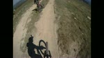
Si quieres, puedes continuar por el Avalancha Classic disfrutando de curvas dentro del bosque, raíces y pequeños saltitos muy accesibles para todos.

Tras unos pasos técnicos dentro del bosque una pasarela de madera con final en un drop muy noble que nos dejará en la pista principal de la estación, disfrutarás de nuevo del trabajo del equipo del Bike Park con una aproximación al remonte con algo más de miga que antes. ¡Estamos empeñados en no desperdiciar ni un metro de desnivel

Bike Park

Recent Activity on Trail

Past Week
  • 0 rides
  •  
6 Months
  • 7 rides
  • 21 miles avg distance
All
  • 31 rides
  • Last: Jun 28, 2026
c1c2c3c4
January
February
March
April
May
June
July
August
September
October
November
December
update trails status or condition

Avalancha Trail Reports

Status:
on May 30, 2026
Variable
Avg: 4.32 (3 votes)
Your vote: 0

view (789)
close
3D
Trail Conditions
  • Unknown
  • Snow Groomed
  • Snow Packed
  • Snow Covered
  • Snow Cover Partial
  • Freeze/thaw Cycle
  • Icy
  • Prevalent Mud
  • Wet
  • Variable
  • Ideal
  • Dry
  • Very Dry
Trail Flow (Ridden Direction)
Trailforks scans users ridelogs to determine the most popular direction each trail is ridden. A good flowing trail network will have most trails flowing in a single direction according to their intension.
The colour categories are based on what percentage of riders are riding a trail in its intended direction.
  • > 96%
  • > 90%
  • > 80%
  • > 70%
  • > 50%
  • < 50%
  • bi-directional trail
  • no data
Trail Last Ridden
Trailforks scans ridelogs to determine the last time a trail was ridden.
  • < 2 days
  • < 1 week
  • < 2 weeks
  • < 1 month
  • < 6 months
  • > 6 months
Trail Ridden Direction
The intended direction a trail should be ridden.
  • Downhill Only
  • Downhill Primary
  • Both Directions
  • Uphill Primary
  • Uphill Only
  • One Direction
Contribute Details
Colors indicate trail is missing specified detail.
  • Description
  • Photos
  • Description & Photos
  • Videos
Trail Popularity ?
Trailforks scans ridelogs to determine which trails are ridden the most in the last 9 months. Trails are compared with nearby trails in the same city region with a possible 25 colour shades. Think of this as a heatmap, more rides = more kinetic energy = warmer colors.
  • most popular
  • popular
  • less popular
  • not popular
ATV/ORV/OHV Filter
Max Vehicle Width
inches
US Cell Coverage
Legend
cell carrier legend

Radar Time
Activity Recordings
Trailforks uses anonymized public activity data. ?
Activity Recordings
Trailforks uses anonymized public activity data. ?
Personal Heatmap
Activity Types
all / none
Options
2
Date range month
Winter Trails
Warning A routing network for winter maps does not exist. Selecting trails using the winter trails layer has been disabled.
Missing Trails
Most Popular
Least Popular
Trails are colored based on popularity. The more popular a trail is, the more red. Less popular trails trend towards green.
Jump Magnitude Heatmap
Heatmap of where riders jump on trails. Zoom in to see individual jumps, click circles to view jump details.
BC Backroad Status

Service Road Atlas is a free to use, community-driven service for viewing and creating reports on the numerous back-country service roads around B.C. and Alberta.

map legend
Slope Aspect
Direction the slope faces
Flat N NE E SE S SW W NW
Trails Deemphasized
Trails are shown in grey.
disable
Only show trails with no bike usage.
Enable
Suggested Layers
Based on selected activity type

    Save the current map location and zoom level as your default home location whenever this page is loaded.

    Save
        Directions to avalancha trailhead (42.266370, -7.299780)

        Photos

        1 more »
        290 |
        Sep 3, 2012 @ 8:59am
        Sep 3, 2012

        Videos

        4 more »
        Manzaneda bike park Avalancha
        40 | Jul 20, 2025 , Pobra De Trives
        Manzaneda 2010 - Avalancha Helmet Cam
        5:05 | 470 | Aug 19, 2010 , Pobra De Trives
        Manzaneda BikePark
        3:51 | 410 | Nov 27, 2010 , Pobra De Trives
        Manzaneda bike park /track - avalancha
        4:26 | 435 | Jul 12, 2010 , Pobra De Trives

        Routes with this trail

        15 miles 2,477 ft 11 Shuttled Race
        Track de la Tsunami Manzaneda 2022.

        Reviews / Comments

        No reviews yet, be the first to write a review or ask a question.
        Use trail reports to comment on trail conditions.


        We hope you've been enjoying Trailforks!

        Create a FREE account to view trail comments and much more.

        • By cliogtt & contributors
        • #46068 - 1,227 views

        Frequently Asked Questions About Avalancha

        Where is Avalancha located?
        Avalancha is located in Manzaneda Bike Park, Pobra De Trives, Spain. It is part of the Manzaneda Bike Park trail network. The trailhead is located at coordinates 42.26637, -7.29978.
        How hard is Avalancha?
        Avalancha is rated as Blue difficulty. The average grade is 15.7%.
        What is the elevation gain for Avalancha?
        The trail has 167 m of elevation descent. The elevation ranges from 1,510 m to 1,677 m.
        Is Avalancha a point to point trail?
        Yes, Avalancha is a point to point trail. The direction is Downhill Only. The trail type is singletrack.

        Hit the Trail

        Open in App

        Get this trail on your phone instantly.
        open trail in app

        Download Trail

        Save to wishlist, Garmin & download.
        save the trail

        Find Related Routes

        Find routes and users activities that include this trail.
        find routes for this trail

        You must enter a description before submitting.