more stats
2.0 miles
Distance
995 ft
Climb
-5 ft
Descent
00:38:04
Avg time
990 ft
Altitude change
918 ft
Altitude min
1,907 ft
Altitude max
918 ft
Altitude start
1,906 ft
Altitude end
9.2%
Grade
-3.7%
Grade max
38.4%
Grade min
2 miles
Distance climb
410 ft
Distance down
180 ft
Distance flat
00:38:04
Avg time

Baccardo Details

  • Activities
    • Mountain Bike
    • E-Bike
    • Winter Fat Bike
    • Hike
    • Trail Running
  • Riding Area
    Alum Rock Park
    San Jose, California
  • Difficulty Rating
  • Local Popularity
    90 in Mountain Biking [+]
    • 85 in Trail Running
    • 85 in Hiking
  • Global Ranking
    #65475 in Mountain Biking [+]
    • #49321 in Trail Running
    • #50782 in Hiking
  • Trail Type
    Singletrack
  • Bike Type
    AM, XC, Fat
  • Climb Difficulty
    Black Diamond
  • Physical Rating
    Hard
  • eBike Allowed
    Yes up to Class 2
  • Land Owner

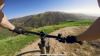
Expect a steep and challenging climb for about 100 yards. At first intersection, stay to the right (talking loop trail to the left is VERY steep.) There will be a short, very steep section followed by a level section for a 1/4 mile. The rest of the trail is nice singletrack with some switchbacks up the grassy hill and cows grazing all around.

At the top of the climb, you can either loop back around to the start of the Boccardo Trail, turn right onto Sierra Vista Trail, or pedal another quarter mile up to the scenic viewpoint.

Access Info

You can access this trail by riding up the Todd Quick trail.

Traditionally Indigenous Territory

Recent Activity on Trail

Past Week
  • 1 rides
  • 9 miles average
6 Months
  • 21 rides
  • 16 miles avg distance
All
  • 148 rides
  • Last: Jul 2, 2026
c1c2c3c4
January
February
March
April
May
June
July
August
September
October
November
December
update trails status or condition

Baccardo Trail Reports

statusdatedescription
Jan 25, 2022 @ 8:50pm
Jan 25, 2022
Oct 3, 2021 @ 4:06pm
Oct 3, 2021
Oct 18, 2020 @ 3:43pm
Oct 18, 2020
The whole park is open but please wear a mask or keep social distancing because of Covid-19
Oct 12, 2020 @ 4:05pm
Oct 12, 2020
Sep 19, 2020 @ 10:31am
Sep 19, 2020
The whole park is open but please wear a mask or keep social distancing because of Covid-19
more »
Status:
on Jan 25, 2022
Dry
Avg: 3.81 (5 votes)
Your vote: 0

view (1,613)
close
3D
Trail Conditions
  • Unknown
  • Snow Groomed
  • Snow Packed
  • Snow Covered
  • Snow Cover Partial
  • Freeze/thaw Cycle
  • Icy
  • Prevalent Mud
  • Wet
  • Variable
  • Ideal
  • Dry
  • Very Dry
Trail Flow (Ridden Direction)
Trailforks scans users ridelogs to determine the most popular direction each trail is ridden. A good flowing trail network will have most trails flowing in a single direction according to their intension.
The colour categories are based on what percentage of riders are riding a trail in its intended direction.
  • > 96%
  • > 90%
  • > 80%
  • > 70%
  • > 50%
  • < 50%
  • bi-directional trail
  • no data
Trail Last Ridden
Trailforks scans ridelogs to determine the last time a trail was ridden.
  • < 2 days
  • < 1 week
  • < 2 weeks
  • < 1 month
  • < 6 months
  • > 6 months
Trail Ridden Direction
The intended direction a trail should be ridden.
  • Downhill Only
  • Downhill Primary
  • Both Directions
  • Uphill Primary
  • Uphill Only
  • One Direction
Contribute Details
Colors indicate trail is missing specified detail.
  • Description
  • Photos
  • Description & Photos
  • Videos
Trail Popularity ?
Trailforks scans ridelogs to determine which trails are ridden the most in the last 9 months. Trails are compared with nearby trails in the same city region with a possible 25 colour shades. Think of this as a heatmap, more rides = more kinetic energy = warmer colors.
  • most popular
  • popular
  • less popular
  • not popular
ATV/ORV/OHV Filter
Max Vehicle Width
inches
US Cell Coverage
Legend
cell carrier legend

Radar Time
Activity Recordings
Trailforks uses anonymized public activity data. ?
Activity Recordings
Trailforks uses anonymized public activity data. ?
Personal Heatmap
Activity Types
all / none
Options
2
Date range month
Winter Trails
Warning A routing network for winter maps does not exist. Selecting trails using the winter trails layer has been disabled.
Missing Trails
Most Popular
Least Popular
Trails are colored based on popularity. The more popular a trail is, the more red. Less popular trails trend towards green.
Jump Magnitude Heatmap
Heatmap of where riders jump on trails. Zoom in to see individual jumps, click circles to view jump details.
BC Backroad Status

Service Road Atlas is a free to use, community-driven service for viewing and creating reports on the numerous back-country service roads around B.C. and Alberta.

map legend
Slope Aspect
Direction the slope faces
Flat N NE E SE S SW W NW
Trails Deemphasized
Trails are shown in grey.
disable
Only show trails with no bike usage.
Enable
Suggested Layers
Based on selected activity type

    Save the current map location and zoom level as your default home location whenever this page is loaded.

    Save
        Directions to baccardo trailhead (37.399880, -121.809440)

        Photos

        8 more »
        184 |
        Jan 25, 2022 @ 8:53pm
        Jan 25, 2022
        171 |
        Oct 8, 2021 @ 5:51pm
        Oct 8, 2021
        284 |
        May 5, 2019 @ 11:23pm
        May 5, 2019
        269 |
        Dec 2, 2018 @ 5:06pm
        Dec 2, 2018

        Videos

        2 more »
        Alum Rock Park “Boccardo” (Advanced) San...
        9:33 | 452 | Jan 25, 2022 , San Jose
        e-MTB | February 2021 Sunset Ride at Alum Rock...
        3:22 | 382 | Mar 28, 2021 , San Jose

        2 Reviews & Comments


        We hope you've been enjoying Trailforks!

        Create a FREE account to view trail comments and much more.

        • By garne2t & contributors
        • #54544 - 4,166 views

        Frequently Asked Questions About Baccardo

        Where is Baccardo located?
        Baccardo is located in Alum Rock Park, San Jose, California, United States. It is part of the Alum Rock Park trail network. The trailhead is located at coordinates 37.39988, -121.80944.
        How hard is Baccardo?
        Baccardo is rated as Blue difficulty. The physical rating is Hard. The average grade is 9.2%. The climb difficulty is rated Black Diamond.
        What is the elevation gain for Baccardo?
        Baccardo has 995 ft of elevation gain. The trail has 5 ft of elevation descent. The elevation ranges from 918 ft to 1,907 ft.
        How long is Baccardo?
        Baccardo is 2.0 miles long. The trail type is singletrack.

        Hit the Trail

        Open in App

        Get this trail on your phone instantly.
        open trail in app

        Download Trail

        Save to wishlist, Garmin & download.
        save the trail

        Find Related Routes

        Find routes and users activities that include this trail.
        find routes for this trail

        You must enter a description before submitting.