more stats
1.9 miles
Distance
42 ft
Climb
-919 ft
Descent
00:17:44
Avg time
-878 ft
Altitude change
4,585 ft
Altitude min
5,469 ft
Altitude max
5,463 ft
Altitude start
4,587 ft
Altitude end
-8.8%
Grade
-35.8%
Grade max
21.5%
Grade min
771 ft
Distance climb
2 miles
Distance down
253 ft
Distance flat
00:17:44
Avg time

Back to Hell Details

  • Activities
    • Mountain Bike
    • Hike
    • Trail Running
  • Riding Area
    Bighorn Ridge
    Hinton, Alberta
  • Difficulty Rating
  • Voted Difficulty
    Blue (2 votes)
  • Local Popularity
    70 in Mountain Biking [+]
    • 70 in Trail Running
    • 5 in Hiking
  • Global Ranking
    #50291 in Mountain Biking [+]
    • #129189 in Trail Running
    • #122193 in Hiking
  • Trail Type
    Singletrack
  • Bike Type
    AM
  • Direction
    Both Directions
    Popular Direction Shown
  • Climb Difficulty
    Black Diamond
  • Physical Rating
    Hard
  • Dogs Allowed
    Yes
  • eBike Allowed
  • TTFs on Trail
    Berm, Bridge, Drop, Jump
  • Land Owner

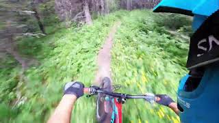
The original Bighorn DH trail was re-worked by Jay Hoots for FRMA with funding from FRMA, HMBA and Yellowhead County. Back to Hell is a black DH from the ridge view after climbing stairway to heaven (12km). Some fast rooty / off camber sections, gravel drainages and wood bridges with drops. Meets up with the Purgatory feeder from Stairway to Heaven (6km) where it becomes a mostly blue pedally Giver Hell downhill to green at the lowest sections.

Local Trail Association

Recent Activity on Trail

Past Week
  • 1 rides
  • 12 miles average
6 Months
  • 1 rides
  • 12 miles avg distance
All
  • 63 rides
  • Last: Jun 15, 2026
c1c2c3c4
January
February
March
April
May
June
July
August
September
October
November
December
update trails status or condition

Back to Hell Trail Reports

statusdatedescription
Sep 14, 2025 @ 9:58am (America/Edmonton)
Sep 14, 2025
No bears or sign today.
May 26, 2025 @ 6:44pm
May 26, 2025
didn't ride the whole thing but it was good with no snow and minimal soft spots
Jul 7, 2024 @ 2:52am
Jul 7, 2024
Oct 16, 2023 @ 10:15am
Oct 16, 2023
Jul 29, 2023 @ 9:50am
Jul 29, 2023
more »
Status:
on Sep 14, 2025
Ideal
Avg: 4.41 (11 votes)
Your vote: 0

view (387)
close
3D
Trail Conditions
  • Unknown
  • Snow Groomed
  • Snow Packed
  • Snow Covered
  • Snow Cover Partial
  • Freeze/thaw Cycle
  • Icy
  • Prevalent Mud
  • Wet
  • Variable
  • Ideal
  • Dry
  • Very Dry
Trail Flow (Ridden Direction)
Trailforks scans users ridelogs to determine the most popular direction each trail is ridden. A good flowing trail network will have most trails flowing in a single direction according to their intension.
The colour categories are based on what percentage of riders are riding a trail in its intended direction.
  • > 96%
  • > 90%
  • > 80%
  • > 70%
  • > 50%
  • < 50%
  • bi-directional trail
  • no data
Trail Last Ridden
Trailforks scans ridelogs to determine the last time a trail was ridden.
  • < 2 days
  • < 1 week
  • < 2 weeks
  • < 1 month
  • < 6 months
  • > 6 months
Trail Ridden Direction
The intended direction a trail should be ridden.
  • Downhill Only
  • Downhill Primary
  • Both Directions
  • Uphill Primary
  • Uphill Only
  • One Direction
Contribute Details
Colors indicate trail is missing specified detail.
  • Description
  • Photos
  • Description & Photos
  • Videos
Trail Popularity ?
Trailforks scans ridelogs to determine which trails are ridden the most in the last 9 months. Trails are compared with nearby trails in the same city region with a possible 25 colour shades. Think of this as a heatmap, more rides = more kinetic energy = warmer colors.
  • most popular
  • popular
  • less popular
  • not popular
ATV/ORV/OHV Filter
Max Vehicle Width
inches
US Cell Coverage
Legend
cell carrier legend

Radar Time
Activity Recordings
Trailforks uses anonymized public activity data. ?
Activity Recordings
Trailforks uses anonymized public activity data. ?
Personal Heatmap
Activity Types
all / none
Options
2
Date range month
Winter Trails
Warning A routing network for winter maps does not exist. Selecting trails using the winter trails layer has been disabled.
Missing Trails
Most Popular
Least Popular
Trails are colored based on popularity. The more popular a trail is, the more red. Less popular trails trend towards green.
Jump Magnitude Heatmap
Heatmap of where riders jump on trails. Zoom in to see individual jumps, click circles to view jump details.
BC Backroad Status

Service Road Atlas is a free to use, community-driven service for viewing and creating reports on the numerous back-country service roads around B.C. and Alberta.

map legend
Slope Aspect
Direction the slope faces
Flat N NE E SE S SW W NW
Trails Deemphasized
Trails are shown in grey.
disable
Only show trails with no bike usage.
Enable
Suggested Layers
Based on selected activity type

    Save the current map location and zoom level as your default home location whenever this page is loaded.

    Save
        Directions to back-to-hell trailhead (53.318400, -117.540520)

        Photos

        13 more »
        497 |
        Jun 19, 2020 @ 8:48pm
        Jun 19, 2020
        292 |
        Mar 5, 2021 @ 9:55am
        Mar 5, 2021
        274 |
        Sep 13, 2020 @ 6:33pm
        Sep 13, 2020
        336 |
        Jun 19, 2020 @ 8:49pm
        Jun 19, 2020

        Videos

        1 more »
        BigHorn Ridge - DH
        4:42 | 566 | Aug 1, 2022 , Hinton

        Routes with this trail

        17 miles 3,148 ft 6 Loop
        The full Hinton Bighorn Ridge experience.
        41 miles 5,148 ft 20 Loop
        This covers all of the xc trails in the Hinton Bike Park.

        6 Reviews & Comments


        We hope you've been enjoying Trailforks!

        Create a FREE account to view trail comments and much more.

        • By napsack & contributors
        • #36599 - 4,305 views

        Frequently Asked Questions About Back to Hell

        Where is Back to Hell located?
        Back to Hell is located in Bighorn Ridge, Hinton, Alberta, Canada. It is part of the Bighorn Ridge trail network. The trailhead is located at coordinates 53.3184, -117.54052.
        How hard is Back to Hell?
        Back to Hell is rated as Black Diamond difficulty. The physical rating is Hard. The average grade is 8.8%. The climb difficulty is rated Black Diamond.
        What is the elevation gain for Back to Hell?
        Back to Hell has 13 m of elevation gain. The trail has 280 m of elevation descent. The elevation ranges from 1,398 m to 1,667 m.
        Is Back to Hell a point to point trail?
        Back to Hell is not a point to point trail. The direction is Both Directions. The trail type is singletrack.

        Hit the Trail

        Open in App

        Get this trail on your phone instantly.
        open trail in app

        Download Trail

        Save to wishlist, Garmin & download.
        save the trail

        Find Related Routes

        Find routes and users activities that include this trail.
        find routes for this trail

        You must enter a description before submitting.