more stats
3,366 ft
Distance
2 ft
Climb
-194 ft
Descent
00:04:18
Avg time
-193 ft
Altitude change
5,158 ft
Altitude min
5,350 ft
Altitude max
5,350 ft
Altitude start
5,157 ft
Altitude end
-5.7%
Grade
-18.5%
Grade max
3.9%
Grade min
66 ft
Distance climb
2,680 ft
Distance down
620 ft
Distance flat
00:04:18
Avg time

Backspacer Details

  • Activities
    • Mountain Bike
    • E-Bike
    • Hike
    • Trail Running
  • Riding Area
    Mountain Ranch Bike Park
    Eagle Mountain, Utah
  • Difficulty Rating
  • Local Popularity
    95 in Mountain Biking [+]
    • 95 in E-Biking
    • 85 in Trail Running
    • 85 in Hiking
  • Global Ranking
    #45936 in Mountain Biking [+]
    • #16210 in E-Biking
    • #49396 in Trail Running
    • #50899 in Hiking
  • Trail Type
    Singletrack
  • Bike Type
    AM, XC
  • Climb Difficulty
    Green
  • Physical Rating
    Easy
  • Family Friendly
    Yes
  • Dogs Allowed
    Yes
  • eBike Allowed
    Yes up to Class 1
  • TTFs on Trail
    Berm, Drop
  • Ride in Rain
    Yes

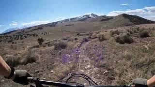
Backspacer stretches from the prayer flags down to where Deadwood and Treadstone join together. It is fun as a quick downhill with some bermed turns, small jumps, and a drop into the wash in the valley below.

Access Info

Located just southwest of the trail flags. Backspacer splits off of the NIrvana trail and heads south where it meets up with the Treadstone trail at the end of the Deadwood trail.

Local Trail Association
Traditionally Indigenous Territory

Recent Activity on Trail

Past Week
  • 2 rides
  • 9 miles average
6 Months
  • 50 rides
  • 10 miles avg distance
All
  • 946 rides
  • Last: Jun 30, 2026
c1c2c3c4
January
February
March
April
May
June
July
August
September
October
November
December
Status:
on Mar 21, 2026
Ideal
Avg: 4 (15 votes)
Your vote: 0

view (7,655)
close
3D
Trail Conditions
  • Unknown
  • Snow Groomed
  • Snow Packed
  • Snow Covered
  • Snow Cover Partial
  • Freeze/thaw Cycle
  • Icy
  • Prevalent Mud
  • Wet
  • Variable
  • Ideal
  • Dry
  • Very Dry
Trail Flow (Ridden Direction)
Trailforks scans users ridelogs to determine the most popular direction each trail is ridden. A good flowing trail network will have most trails flowing in a single direction according to their intension.
The colour categories are based on what percentage of riders are riding a trail in its intended direction.
  • > 96%
  • > 90%
  • > 80%
  • > 70%
  • > 50%
  • < 50%
  • bi-directional trail
  • no data
Trail Last Ridden
Trailforks scans ridelogs to determine the last time a trail was ridden.
  • < 2 days
  • < 1 week
  • < 2 weeks
  • < 1 month
  • < 6 months
  • > 6 months
Trail Ridden Direction
The intended direction a trail should be ridden.
  • Downhill Only
  • Downhill Primary
  • Both Directions
  • Uphill Primary
  • Uphill Only
  • One Direction
Contribute Details
Colors indicate trail is missing specified detail.
  • Description
  • Photos
  • Description & Photos
  • Videos
Trail Popularity ?
Trailforks scans ridelogs to determine which trails are ridden the most in the last 9 months. Trails are compared with nearby trails in the same city region with a possible 25 colour shades. Think of this as a heatmap, more rides = more kinetic energy = warmer colors.
  • most popular
  • popular
  • less popular
  • not popular
ATV/ORV/OHV Filter
Max Vehicle Width
inches
US Cell Coverage
Legend
cell carrier legend

Radar Time
Activity Recordings
Trailforks uses anonymized public activity data. ?
Activity Recordings
Trailforks uses anonymized public activity data. ?
Personal Heatmap
Activity Types
all / none
Options
2
Date range month
Winter Trails
Warning A routing network for winter maps does not exist. Selecting trails using the winter trails layer has been disabled.
Missing Trails
Most Popular
Least Popular
Trails are colored based on popularity. The more popular a trail is, the more red. Less popular trails trend towards green.
Jump Magnitude Heatmap
Heatmap of where riders jump on trails. Zoom in to see individual jumps, click circles to view jump details.
BC Backroad Status

Service Road Atlas is a free to use, community-driven service for viewing and creating reports on the numerous back-country service roads around B.C. and Alberta.

map legend
Slope Aspect
Direction the slope faces
Flat N NE E SE S SW W NW
Trails Deemphasized
Trails are shown in grey.
disable
Only show trails with no bike usage.
Enable
Suggested Layers
Based on selected activity type

    Save the current map location and zoom level as your default home location whenever this page is loaded.

    Save
        Directions to backspacer trailhead (40.342290, -111.984010)

        Photos

        19 more »
        171 |
        Apr 22, 2019 @ 2:32pm
        Apr 22, 2019
        202 |
        Oct 13, 2018 @ 10:08pm
        Oct 13, 2018
        79 |
        Jul 17, 2021 @ 7:54pm
        Jul 17, 2021
        98 |
        May 26, 2021 @ 7:17am
        May 26, 2021

        Videos

        8 more »
        youtuber Eagle Mountain Mtb, Backspacer Trail | New...
        3:49 | 609 | Sep 6, 2018 , Eagle Mountain
        Backspacer - Eagle Mtn, UT - MTB Trail Preview
        0:48 | 81 | Apr 26, 2025 , Eagle Mountain
        Backspacer - Eagle Mountain Utah
        132 | Mar 24, 2024 , Eagle Mountain
        Backspacer - Eagle Mountain 2020
        3:01 | 285 | Nov 28, 2020 , Eagle Mountain

        Routes with this trail

        5.0 10 miles 1,174 ft 27 Loop
        Ride this loop Anti-Clockwise for a more climby (dog friendly) loop, Clockwise is a bit more descendy and...
        4.0 21 miles 2,496 ft 22
        This ride provides a sampling of each of the trails in Eagle Mountain. While most of he trails are XC-ish...
        4.4 13 miles 1,615 ft 45
        Route to get in 2,000' of climbing, mostly on singletrack.

        5 Reviews & Comments


        We hope you've been enjoying Trailforks!

        Create a FREE account to view trail comments and much more.

        • By Snood72 & contributors
        • #115375 - 2,706 views

        Frequently Asked Questions About Backspacer

        Where is Backspacer located?
        Backspacer is located in Mountain Ranch Bike Park, Eagle Mountain, Utah, United States. It is part of the Mountain Ranch Bike Park trail network. The trailhead is located at coordinates 40.34229, -111.98401.
        How hard is Backspacer?
        Backspacer is rated as Blue difficulty. The physical rating is Easy. The average grade is 5.7%. The climb difficulty is rated Green.
        What is the elevation gain for Backspacer?
        Backspacer has 2 ft of elevation gain. The trail has 194 ft of elevation descent. The elevation ranges from 5,158 ft to 5,350 ft.
        How long is Backspacer?
        Backspacer is 3,366 ft long. The trail type is singletrack.

        Hit the Trail

        Open in App

        Get this trail on your phone instantly.
        open trail in app

        Download Trail

        Save to wishlist, Garmin & download.
        save the trail

        Find Related Routes

        Find routes and users activities that include this trail.
        find routes for this trail

        You must enter a description before submitting.