more stats
1,368 ft
Distance
28 ft
Climb
-65 ft
Descent
00:02:38
Avg time
-37 ft
Altitude change
399 ft
Altitude min
464 ft
Altitude max
435 ft
Altitude start
400 ft
Altitude end
-2.7%
Grade
-20.3%
Grade max
20.3%
Grade min
328 ft
Distance climb
955 ft
Distance down
82 ft
Distance flat
00:02:38
Avg time

Bak Rustad Details

  • Activities
    • Mountain Bike
  • Riding Area
    Kykkelsrud
    Askim
  • Difficulty Rating
  • Local Popularity
    95 in Mountain Biking
  • Global Ranking
    #57616 in Mountain Biking
  • Trail Type
    Singletrack
  • Bike Type
    AM
  • Climb Difficulty
    Double Black Diamond
  • Physical Rating
    Hard
  • Trail Visibility
    Always easy to follow
  • Dogs Allowed
    Yes
  • eBike Allowed
    Yes up to Class 1

Norsk
Stien egner seg som for nedover, for det er veldig krevende løype å komme seg opp fra Løkkekroken, løypa starter med lette stigninger, og svinger til venstre med en tømmerrekke kryssing, deretter en ganske bratt stigning, som de fleste avanserte ryttere ville kunne ri opp, midtpartiet på toppen, er flytende, med mange svinger, men lenger ned mot elva er det mer krevende, med bratte steinheller, skarpere svinger, må du navigere mellom trær, røtter, så det blir lettere nedover, stien kobler sammen 3 stier,den til høyre/nord er en blindvei, den rett ned kobles til Fossstien, stien til venstre kobles til stien der det er en gressbane hvor man kan se Smaalenes bru.

English
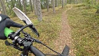
The trail is suited as for doing downhill, as it's very demanding trail to get up f rom Løkkekroken the trail starts with easy climbs, and turns to the left with a log row stream crossing, then a a pretty steep climb, which most advanced riders would be able to ride up, the mid section at the top, is flowy, with many turns, but further down towards the river, it's more demanding, with steep rock slabs, sharper twitchy turns, you need to navigate between trees, roots, then it gets easier down, the trail connects 3 trails,the one to the right/north is a dead end, the one straight down connects to Fossstien, the trail on the left connects to the trail where there is a grass field where you can see Smaalenes bridge.

Recent Activity on Trail

Past Week
  • 0 rides
  •  
6 Months
  • 0 rides
  •  
All
  • 1 rides
  • Last: Jun 22, 2025
c1c2c3c4
January
February
March
April
May
June
July
August
September
October
November
December
update trails status or condition

Bak Rustad Trail Reports

statusdatedescription
Jun 11, 2020 @ 7:11am
Jun 11, 2020
reporter
more »
Status:
on Jun 11, 2020
Ideal
Avg: 4.13 (1 votes)
Your vote: 0

view (13)
close
3D
Trail Conditions
  • Unknown
  • Snow Groomed
  • Snow Packed
  • Snow Covered
  • Snow Cover Partial
  • Freeze/thaw Cycle
  • Icy
  • Prevalent Mud
  • Wet
  • Variable
  • Ideal
  • Dry
  • Very Dry
Trail Flow (Ridden Direction)
Trailforks scans users ridelogs to determine the most popular direction each trail is ridden. A good flowing trail network will have most trails flowing in a single direction according to their intension.
The colour categories are based on what percentage of riders are riding a trail in its intended direction.
  • > 96%
  • > 90%
  • > 80%
  • > 70%
  • > 50%
  • < 50%
  • bi-directional trail
  • no data
Trail Last Ridden
Trailforks scans ridelogs to determine the last time a trail was ridden.
  • < 2 days
  • < 1 week
  • < 2 weeks
  • < 1 month
  • < 6 months
  • > 6 months
Trail Ridden Direction
The intended direction a trail should be ridden.
  • Downhill Only
  • Downhill Primary
  • Both Directions
  • Uphill Primary
  • Uphill Only
  • One Direction
Contribute Details
Colors indicate trail is missing specified detail.
  • Description
  • Photos
  • Description & Photos
  • Videos
Trail Popularity ?
Trailforks scans ridelogs to determine which trails are ridden the most in the last 9 months. Trails are compared with nearby trails in the same city region with a possible 25 colour shades. Think of this as a heatmap, more rides = more kinetic energy = warmer colors.
  • most popular
  • popular
  • less popular
  • not popular
ATV/ORV/OHV Filter
Max Vehicle Width
inches
US Cell Coverage
Legend
cell carrier legend

Radar Time
Activity Recordings
Trailforks uses anonymized public activity data. ?
Activity Recordings
Trailforks uses anonymized public activity data. ?
Personal Heatmap
Activity Types
all / none
Options
2
Date range month
Winter Trails
Warning A routing network for winter maps does not exist. Selecting trails using the winter trails layer has been disabled.
Missing Trails
Most Popular
Least Popular
Trails are colored based on popularity. The more popular a trail is, the more red. Less popular trails trend towards green.
Jump Magnitude Heatmap
Heatmap of where riders jump on trails. Zoom in to see individual jumps, click circles to view jump details.
BC Backroad Status

Service Road Atlas is a free to use, community-driven service for viewing and creating reports on the numerous back-country service roads around B.C. and Alberta.

map legend
Slope Aspect
Direction the slope faces
Flat N NE E SE S SW W NW
Trails Deemphasized
Trails are shown in grey.
disable
Only show trails with no bike usage.
Enable
Suggested Layers
Based on selected activity type

    Save the current map location and zoom level as your default home location whenever this page is loaded.

    Save
        Directions to bak-rustad trailhead (59.594350, 11.098470)

        Photos

        6 more »
        22 |
        Oct 28, 2022 @ 11:58am
        Oct 28, 2022
        30 |
        Oct 28, 2022 @ 11:44am
        Oct 28, 2022
        23 |
        Oct 28, 2022 @ 11:43am
        Oct 28, 2022
        33 |
        Oct 28, 2022 @ 11:43am
        Oct 28, 2022

        Videos

        1 more »
        youtuber 29 Sep 2022 Down to the river
        6:43 | 89 | Jun 13, 2023 , Askim

        Reviews / Comments

        No reviews yet, be the first to write a review or ask a question.
        Use trail reports to comment on trail conditions.


        We hope you've been enjoying Trailforks!

        Create a FREE account to view trail comments and much more.

        Frequently Asked Questions About Bak Rustad

        Where is Bak Rustad located?
        Bak Rustad is located in Kykkelsrud, Askim, Norway. It is part of the Kykkelsrud trail network. The trailhead is located at coordinates 59.59435, 11.09847.
        How hard is Bak Rustad?
        Bak Rustad is rated as Red difficulty. The physical rating is Hard. The average grade is 2.7%. The climb difficulty is rated Double Black Diamond.
        What is the elevation gain for Bak Rustad?
        Bak Rustad has 28 ft of elevation gain. The trail has 65 ft of elevation descent. The elevation ranges from 399 ft to 464 ft.
        How long is Bak Rustad?
        Bak Rustad is 1,368 ft long. The trail type is singletrack.

        Hit the Trail

        Open in App

        Get this trail on your phone instantly.
        open trail in app

        Download Trail

        Save to wishlist, Garmin & download.
        save the trail

        Find Related Routes

        Find routes and users activities that include this trail.
        find routes for this trail

        You must enter a description before submitting.