more stats
3,665 ft
Distance
-657 ft
Descent
00:03:19
Avg time
-657 ft
Altitude change
735 ft
Altitude min
1,392 ft
Altitude max
1,392 ft
Altitude start
735 ft
Altitude end
-17.9%
Grade
-53.8%
Grade max
-6.4%
Grade min
3,665 ft
Distance down
00:03:19
Avg time

Balinisce Details

  • Activities
    • Mountain Bike
  • Riding Area
    Vipavska dolina
    Ajdovščina
  • Difficulty Rating
  • Local Popularity
    60 in Mountain Biking
  • Global Ranking
    #92080 in Mountain Biking
  • Trail Type
    Singletrack
  • Bike Type
    DH, AM
  • Direction
    Downhill Only
    Popular Direction Shown
  • Climb Difficulty
    Black Diamond
  • Physical Rating
    Moderate
  • Trail Visibility
    Always easy to follow
  • Dogs Allowed
    Yes
  • eBike Allowed
  • Land Owner

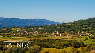
Natural trail with small rocks, without technical objects. Watch out for main road at the end.

Access Info

Park at MC Hisa mladih in Ajdovscina. Access road goes next to source of river Hubelj and through village Lokavec.

Recent Activity on Trail

Past Week
  • 0 rides
  •  
6 Months
  • 1 rides
  • 20 miles avg distance
All
  • 12 rides
  • Last: May 10, 2026
c1c2c3c4
January
February
March
April
May
June
July
August
September
October
November
December
update trails status or condition

Balinisce Trail Reports

statusdatedescription
Nov 9, 2024 @ 11:17am
Nov 9, 2024
Jul 4, 2024 @ 4:08am
Jul 4, 2024
Tree on a trail, can ride around. Otherwise all good!
Feb 5, 2024 @ 6:47am
Feb 5, 2024
Feb 4, 2024 @ 5:13am
Feb 4, 2024
All the fallen trees were cleared or there is a detour set around, running good, except for being extremely dry, sketchy loose. ;)
Mar 11, 2023 @ 12:17pm
Mar 11, 2023
more »
Status:
on Nov 9, 2024
Dry
Avg: 4.29 (4 votes)
Your vote: 0

view (330)
close
3D
Trail Conditions
  • Unknown
  • Snow Groomed
  • Snow Packed
  • Snow Covered
  • Snow Cover Partial
  • Freeze/thaw Cycle
  • Icy
  • Prevalent Mud
  • Wet
  • Variable
  • Ideal
  • Dry
  • Very Dry
Trail Flow (Ridden Direction)
Trailforks scans users ridelogs to determine the most popular direction each trail is ridden. A good flowing trail network will have most trails flowing in a single direction according to their intension.
The colour categories are based on what percentage of riders are riding a trail in its intended direction.
  • > 96%
  • > 90%
  • > 80%
  • > 70%
  • > 50%
  • < 50%
  • bi-directional trail
  • no data
Trail Last Ridden
Trailforks scans ridelogs to determine the last time a trail was ridden.
  • < 2 days
  • < 1 week
  • < 2 weeks
  • < 1 month
  • < 6 months
  • > 6 months
Trail Ridden Direction
The intended direction a trail should be ridden.
  • Downhill Only
  • Downhill Primary
  • Both Directions
  • Uphill Primary
  • Uphill Only
  • One Direction
Contribute Details
Colors indicate trail is missing specified detail.
  • Description
  • Photos
  • Description & Photos
  • Videos
Trail Popularity ?
Trailforks scans ridelogs to determine which trails are ridden the most in the last 9 months. Trails are compared with nearby trails in the same city region with a possible 25 colour shades. Think of this as a heatmap, more rides = more kinetic energy = warmer colors.
  • most popular
  • popular
  • less popular
  • not popular
ATV/ORV/OHV Filter
Max Vehicle Width
inches
US Cell Coverage
Legend
cell carrier legend

Radar Time
Activity Recordings
Trailforks uses anonymized public activity data. ?
Activity Recordings
Trailforks uses anonymized public activity data. ?
Personal Heatmap
Activity Types
all / none
Options
2
Date range month
Winter Trails
Warning A routing network for winter maps does not exist. Selecting trails using the winter trails layer has been disabled.
Missing Trails
Most Popular
Least Popular
Trails are colored based on popularity. The more popular a trail is, the more red. Less popular trails trend towards green.
Jump Magnitude Heatmap
Heatmap of where riders jump on trails. Zoom in to see individual jumps, click circles to view jump details.
BC Backroad Status

Service Road Atlas is a free to use, community-driven service for viewing and creating reports on the numerous back-country service roads around B.C. and Alberta.

map legend
Slope Aspect
Direction the slope faces
Flat N NE E SE S SW W NW
Trails Deemphasized
Trails are shown in grey.
disable
Only show trails with no bike usage.
Enable
Suggested Layers
Based on selected activity type

    Save the current map location and zoom level as your default home location whenever this page is loaded.

    Save
        Directions to balinisce trailhead (45.913340, 13.907140)

        Photos

        2 more »
        33 |
        Dec 22, 2022 @ 4:08am
        Dec 22, 2022
        50 |
        Dec 7, 2021 @ 8:17am
        Dec 7, 2021

        Videos

        1 more »
        BALINIŠČE 2023
        3:32 | 244 | Apr 28, 2023 , Ajdovščina

        Reviews / Comments

        No reviews yet, be the first to write a review or ask a question.
        Use trail reports to comment on trail conditions.


        We hope you've been enjoying Trailforks!

        Create a FREE account to view trail comments and much more.

        • By gasper-knavsTF Pro AED Maribor & contributors
        • #173009 - 932 views

        Frequently Asked Questions About Balinisce

        Where is Balinisce located?
        Balinisce is located in Vipavska dolina, Ajdovščina, Slovenia. It is part of the Vipavska dolina trail network. The trailhead is located at coordinates 45.91334, 13.90714.
        How hard is Balinisce?
        Balinisce is rated as Blue difficulty. The physical rating is Moderate. The average grade is 17.9%. The climb difficulty is rated Black Diamond.
        What is the elevation gain for Balinisce?
        The trail has 657 ft of elevation descent. The elevation ranges from 735 ft to 1,392 ft.
        Is Balinisce a point to point trail?
        Yes, Balinisce is a point to point trail. The direction is Downhill Only. The trail type is singletrack.

        Hit the Trail

        Open in App

        Get this trail on your phone instantly.
        open trail in app

        Download Trail

        Save to wishlist, Garmin & download.
        save the trail

        Find Related Routes

        Find routes and users activities that include this trail.
        find routes for this trail

        You must enter a description before submitting.