more stats
4,954 ft
Distance
-554 ft
Descent
00:04:36
Avg time
-556 ft
Altitude change
5,585 ft
Altitude min
6,141 ft
Altitude max
6,141 ft
Altitude start
5,584 ft
Altitude end
-11.2%
Grade
-43.1%
Grade max
1.7%
Grade min
75 ft
Distance climb
4,803 ft
Distance down
72 ft
Distance flat
00:04:36
Avg time

Balloon Details

  • Activities
    • Mountain Bike
    • E-Bike
  • Riding Area
    MADE BIKE
    Madesimo
  • Difficulty Rating
  • Voted Difficulty
    Blue (1 vote)
  • Local Popularity
    100 in Mountain Biking [+]
    • 100 in E-Biking
  • Global Ranking
    #40071 in Mountain Biking [+]
    • #6356 in E-Biking
  • Trail Type
    Machine Groomed
  • Bike Type
    DH, AM, XC
  • Trail Visibility
    Always easy to follow
  • Family Friendly
    Yes
  • Dogs Allowed
    Yes
  • eBike Allowed
    Yes up to Class 1
  • TTFs on Trail
    Berm, Jump, Pump Track, Roller Coaster, Other
  • Land Owner
    Comune di Madesimo

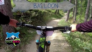
Pista “blu” facile e divertente che assicura anche ai principianti belle emozioni ed ai biker esperti ritmo e pulizia di guida. Ideale per “iniziare” i propri amici al freeriding

Disclaimer

Ride at your own risk

Bike Park

Local Trail Association

Recent Activity on Trail

Past Week
  • 0 rides
  •  
6 Months
  • 0 rides
  •  
All
  • 73 rides
  • Last: Oct 28, 2025
c1c2c3c4
January
February
March
April
May
June
July
August
September
October
November
December
update trails status or condition

Balloon Trail Reports

statusdatedescription
Jun 22, 2025 @ 3:18am
Jun 22, 2025
Jun 21, 2025 @ 10:33am
Jun 21, 2025
Stanno facendo pulizia in vista dell’apertura, comunque ottime condizioni
Aug 9, 2024 @ 6:32am
Aug 9, 2024
Qualche pietra sul percorso nel tratto in comune con il trail i Larici.
Jun 29, 2024 @ 6:42am
Jun 29, 2024
Jun 29, 2024 @ 6:16am
Jun 29, 2024
more »
Status:
on Jun 22, 2025
Ideal
Avg: 3.99 (3 votes)
Your vote: 0

view (3,041)
close
3D
Trail Conditions
  • Unknown
  • Snow Groomed
  • Snow Packed
  • Snow Covered
  • Snow Cover Partial
  • Freeze/thaw Cycle
  • Icy
  • Prevalent Mud
  • Wet
  • Variable
  • Ideal
  • Dry
  • Very Dry
Trail Flow (Ridden Direction)
Trailforks scans users ridelogs to determine the most popular direction each trail is ridden. A good flowing trail network will have most trails flowing in a single direction according to their intension.
The colour categories are based on what percentage of riders are riding a trail in its intended direction.
  • > 96%
  • > 90%
  • > 80%
  • > 70%
  • > 50%
  • < 50%
  • bi-directional trail
  • no data
Trail Last Ridden
Trailforks scans ridelogs to determine the last time a trail was ridden.
  • < 2 days
  • < 1 week
  • < 2 weeks
  • < 1 month
  • < 6 months
  • > 6 months
Trail Ridden Direction
The intended direction a trail should be ridden.
  • Downhill Only
  • Downhill Primary
  • Both Directions
  • Uphill Primary
  • Uphill Only
  • One Direction
Contribute Details
Colors indicate trail is missing specified detail.
  • Description
  • Photos
  • Description & Photos
  • Videos
Trail Popularity ?
Trailforks scans ridelogs to determine which trails are ridden the most in the last 9 months. Trails are compared with nearby trails in the same city region with a possible 25 colour shades. Think of this as a heatmap, more rides = more kinetic energy = warmer colors.
  • most popular
  • popular
  • less popular
  • not popular
ATV/ORV/OHV Filter
Max Vehicle Width
inches
US Cell Coverage
Legend
cell carrier legend

Radar Time
Activity Recordings
Trailforks uses anonymized public activity data. ?
Activity Recordings
Trailforks uses anonymized public activity data. ?
Personal Heatmap
Activity Types
all / none
Options
2
Date range month
Winter Trails
Warning A routing network for winter maps does not exist. Selecting trails using the winter trails layer has been disabled.
Missing Trails
Most Popular
Least Popular
Trails are colored based on popularity. The more popular a trail is, the more red. Less popular trails trend towards green.
Jump Magnitude Heatmap
Heatmap of where riders jump on trails. Zoom in to see individual jumps, click circles to view jump details.
BC Backroad Status

Service Road Atlas is a free to use, community-driven service for viewing and creating reports on the numerous back-country service roads around B.C. and Alberta.

map legend
Slope Aspect
Direction the slope faces
Flat N NE E SE S SW W NW
Trails Deemphasized
Trails are shown in grey.
disable
Only show trails with no bike usage.
Enable
Suggested Layers
Based on selected activity type

    Save the current map location and zoom level as your default home location whenever this page is loaded.

    Save
        Directions to balloon trailhead (46.431230, 9.374410)

        Photos

        5 more »
        53 |
        Jun 6, 2022 @ 12:59pm
        Jun 6, 2022
        58 |
        Jun 6, 2022 @ 12:59pm
        Jun 6, 2022
        401 |
        Sep 10, 2011 @ 7:21am
        Sep 10, 2011
        31 |
        Aug 11, 2024 @ 12:11am
        Aug 11, 2024

        Videos

        5 more »
        Balloon Trail | MadeBike
        5:55 | 97 | Sep 5, 2024 , Madesimo
        Balloon - Madesimo Bikepark
        5:44 | 124 | Nov 10, 2023 , Madesimo
        Madesimo Bike park Ballon
        8:52 | 173 | Sep 14, 2023 , Madesimo
        LA MIA PRIMA GARA DI DOWNHILL | Madesimo...
        4:38 | 137 | Sep 14, 2023 , Madesimo

        Reviews / Comments

        No reviews yet, be the first to write a review or ask a question.
        Use trail reports to comment on trail conditions.


        We hope you've been enjoying Trailforks!

        Create a FREE account to view trail comments and much more.

        • By toddTF Pro Trailforks & contributors
        • #153661 - 808 views

        Frequently Asked Questions About Balloon

        Where is Balloon located?
        Balloon is located in MADE BIKE, Madesimo, Italy. It is part of the MADE BIKE trail network. The trailhead is located at coordinates 46.43123, 9.37441.
        How hard is Balloon?
        Balloon is rated as Blue difficulty. The average grade is 11.2%.
        What is the elevation gain for Balloon?
        The trail has 554 ft of elevation descent. The elevation ranges from 5,585 ft to 6,141 ft.
        How long is Balloon?
        Balloon is 4,954 ft long. The trail type is machine groomed.

        Hit the Trail

        Open in App

        Get this trail on your phone instantly.
        open trail in app

        Download Trail

        Save to wishlist, Garmin & download.
        save the trail

        Find Related Routes

        Find routes and users activities that include this trail.
        find routes for this trail

        You must enter a description before submitting.