

more stats
2,408 ft
Distance
-360 ft
Descent
00:05:04
Avg time
-360 ft
Altitude change
5,031 ft
Altitude min
5,390 ft
Altitude max
5,390 ft
Altitude start
5,030 ft
Altitude end
-14.9%
Grade
-49%
Grade max
-3.2%
Grade min
2,408 ft
Distance down
00:05:04
Avg time

Bambi Details

  • Activities
    • Mountain Bike
    • E-Bike
    • Hike
    • Trail Running
  • Riding Area
    La Barranca
    Navacerrada
  • Difficulty Rating
  • Local Popularity
    75 in Mountain Biking heatmap [+]
    • 85 in E-Biking
    • 5 in Trail Running
    • 5 in Hiking
  • Global Ranking
    #109565 in Mountain Biking [+]
    • #3078 in E-Biking
    • #305453 in Trail Running
    • #295648 in Hiking
  • National Ranking
    #8,457 in Mountain Biking · Spain [+]
    • #1,196 in E-Biking
    • #32,229 in Trail Running
    • #29,260 in Hiking
  • Hiking SAC Scale
    T1 Hiking
  • Trail Exposure
    Normal
  • Trail Type
    Singletrack
  • Bike Type
    AM
  • Direction
    Downhill Primary[+]
    Popular Direction Shown
    • Downhill Primary for E-Biking
    • Downhill Primary for Trail Running
    • Downhill Primary for Hiking
  • Physical Rating
    Moderate
  • Trail Visibility
    Always easy to follow
  • Dogs Allowed
    Yes
  • eBike Allowed
    Yes up to Class 1
  • TTFs on Trail
    Berm, Drop, Rock Garden

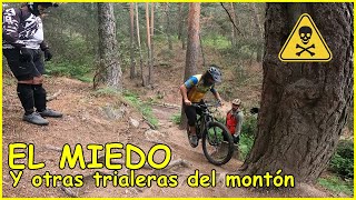
Es una de las trialeras míticas de la Sierra Norte de Madrid. La parte superior es una zona de raíces donde se han formado varias trazadas, algunas mas directas, otras haciendo zetas, elige tu trazada. La parte inferior tras pasar al lado de la Pista de La Barranca tiene varias zonas rápidas de sendero con algo menos de raíces y menor inclinación.

Tags
BermsDropsRock gardens

Recent Activity on Trail

Past Week
  • 0 rides
  •  
6 Months
  • 18 rides
  • 22 miles avg distance
All
  • 211 rides
  • Last: Oct 28, 2026
c1c2c3c4
January
February
March
April
May
June
July
August
September
October
November
December
update trails status or condition

Bambi Trail Reports

statusdatedescription
Nov 7, 2026 @ 4:38pm (Europe/Madrid)
Nov 7, 2026
Primera parte del sendero muy seco, A LOS DE LAS EBIKES, ESTE SENDERO ES DE BAJADA. Casi me como a un grupo de jubilados que prefería subir por...
Aug 31, 2026 @ 9:01am (Europe/Madrid)
Aug 31, 2026
Jul 1, 2026 @ 8:22am (Europe/Madrid)
Jun 30, 2026
Muy seco y con la vegetación sacándote al contraperalte tras la zona de raíces de abajo.
May 30, 2026 @ 10:29am (Europe/Madrid)
May 30, 2026
May 8, 2026 @ 10:47pm (Europe/Madrid)
May 8, 2026
Perfecto estado tras las lluvias
more »
Status:
on Nov 7, 2026
Dry
Avg: 4.17 (8 votes)
Your vote: 0

view (938)
close
      Directions to bambi-16421 trailhead (40.753250, -4.011350)

      Photos

      6 more »
      mtb
      74 |
      Apr 19, 2023 @ 11:47am
      Apr 19, 2023
      mtb
      68 |
      Apr 19, 2023 @ 11:48am
      Apr 19, 2023
      mtb
      180 |
      Apr 25, 2016 @ 3:40pm
      Apr 25, 2016
      report
      mtb
      57 |
      May 8, 2026 @ 1:49pm
      May 8, 2026

      Videos

      8 more »
      youtuber ‍♀️ ⛰ Trialera Bambi | Navacerrada...
      mtb
      6:26 | 252 | May 7, 2022 , Navacerrada
      youtuber El MIEDO y trialeras de La Barranca ☠️​...
      mtb
      9:28 | 245 | Jul 8, 2024 , Navacerrada
      youtuber Viaje a Whistler ️​ Pasando Miedo en el...
      mtb
      8:46 | 107 | Sep 11, 2023 , Navacerrada
      youtuber NAVACERRADA Summer Festival ​♻️​...
      mtb
      8:14 | 132 | Aug 2, 2022 , Navacerrada

      Routes with this trail

      more »
      14 miles • 2,986 ft • 9 • Loop •
      Ruta de dificultad media por Navacerrada y parte de Cercedilla, recorriendo algunos senderos clásicos de...
      38 miles • 7,666 ft • 13 •
      Veremos a ver que sale de esta ruta con ebike
      19 miles • 3,130 ft • 7 • Loop •
      Nẹp Inox chữ V có bị gỉ trong nước không? Rỉ sét là một phản ứng hóa học làm...
      4.7 ★★★★★
      8 Ratings
      5 ★ 63%
      4 ★ 38%
      3 ★
      2 ★
      1 ★

      4 Reviews & Comments

      hongoalpino hongoalpino
      Bajada muy rápida que conecta con correcaminos y el ventorrillo
      Cronoramer
      Muy bonito y espectacular. Ojo a las raíces en el tramo superior.
      LZ1975 LZ1975
      Bonita senda, perfecta para culminar ruta por La Barranca. La primera parte más inclinada y con raíces. Dependiendo del nivel, hay que bajar con precaución y es posible que tengas que echar algún pie a tierra. La segunda parte tiene más flow y ofrece bonitas vistas al valle. Tiene un par de curvas algo cerrada y sigue el árbol caído (se pasa por debajo sin problemas).

      We hope you've been enjoying Trailforks!

      Create a FREE account to view all trail reviews and much more.

      • By coletassoft & contributors
      • #16421 - 2,850 views

      Frequently Asked Questions

      ▼ Where is Bambi located?
      Bambi is located in La Barranca, Navacerrada, Spain. It is part of the La Barranca trail network. The trailhead is located at coordinates 40.75325, -4.01135.
      ▼ How hard is Bambi?
      Bambi is rated as Red difficulty. The physical rating is Moderate. The average grade is 14.9%.
      ▼ What is the elevation gain for Bambi?
      The trail has 360 ft of elevation descent. The elevation ranges from 5,031 ft to 5,390 ft.
      ▼ Is Bambi a point to point trail?
      Bambi is not a point to point trail. The direction is Downhill Primary. The trail type is singletrack.
      ▼ How long is Bambi?
      Bambi is 2,408 ft long. The trail type is singletrack.
      ▼ Are dogs allowed on Bambi?
      Yes, dogs are allowed on Bambi. Please keep dogs on a leash where required and clean up after them.
      ▼ How do I access Bambi? Where is the closest parking trailhead?
      The closest parking and trailhead locations to Bambi are: View all parking locations in the area.
      ▼ How long does it take to ride Bambi?
      Based on recorded activities, it takes an average of 5 minutes to ride Bambi. The trail is 2,408 ft long. Actual times will vary based on fitness level, conditions, and pace. View recent activity logs for more details.
      ▼ How busy is Bambi?
      Bambi is a very popular trail. There have been 973 recorded activities on this trail. The trail has received 938 check-ins. View recent activity on this trail.

      Hit the Trail

      Open in App

      Get this trail on your phone instantly.

      open trail in app

      Download Trail

      Save to wishlist, Garmin & download.
      save the trail

      Find Related Routes

      Find routes and users activities that include this trail.
      find routes for this trail

      You must enter a description before submitting.

