1,684 ft
Distance
17 ft
Climb
-193 ft
Descent
00:02:22
Avg time

Barney Flow Details

  • Activities
    • Mountain Bike
    • Hike
    • Trail Running
  • Riding Area
    Breckenridge
    , Colorado
  • Difficulty Rating
  • Voted Difficulty
    Black Diamond (2 votes)
  • Trail Type
    Singletrack
  • Direction
    Downhill Only
    Popular direction shown
  • Dogs Allowed
    Yes
  • eBike Allowed
  • Global Ranking
    #3184 in Mountain Biking [+]
    • #21190 in Trail Running
    • #15194 in Hiking
  • Local Popularity
    100 in Mountain Biking [+]
    • 60 in Trail Running
    • 55 in Hiking

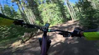
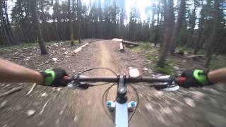
Fun downhill trail with nice berms and little table tops to air out on. Mostly packed dirt, may have some brake bumps here and there, but not rocky or loose. You can roll everything and take it slow and easy.

Local Trail Association
Traditionally Indigenous Territory
More Stats for Barney Flow mountain bike trail trail
  • Altitude change
    -175 ft
  • Altitude min
    9,900 ft
  • Altitude max
    10,075 ft
  • Altitude start
    10,075 ft
  • Altitude end
    9,900 ft
  • Grade
    -10.415%
  • Grade max
    -25.778%
  • Grade min
    16.472%
  • Distance climb
    105 ft
  • Distance down
    1,528 ft
  • Distance flat
    51 ft
  • Avg time
    00:02:22
  • Avg reverse time
    00:08:58
  • view trail stats
Status:
on Aug 19, 2024
Dry
Avg: 4.3 (13 votes)
Your vote: 0

view (4,958)
close
3D
Trail Conditions
  • Unknown
  • Snow Groomed
  • Snow Packed
  • Snow Covered
  • Snow Cover Partial
  • Freeze/thaw Cycle
  • Icy
  • Prevalent Mud
  • Wet
  • Variable
  • Ideal
  • Dry
  • Very Dry
Trail Flow (Ridden Direction)
Trailforks scans users ridelogs to determine the most popular direction each trail is ridden. A good flowing trail network will have most trails flowing in a single direction according to their intension.
The colour categories are based on what percentage of riders are riding a trail in its intended direction.
  • > 96%
  • > 90%
  • > 80%
  • > 70%
  • > 50%
  • < 50%
  • bi-directional trail
  • no data
Trail Last Ridden
Trailforks scans ridelogs to determine the last time a trail was ridden.
  • < 2 days
  • < 1 week
  • < 2 weeks
  • < 1 month
  • < 6 months
  • > 6 months
Trail Ridden Direction
The intended direction a trail should be ridden.
  • Downhill Only
  • Downhill Primary
  • Both Directions
  • Uphill Primary
  • Uphill Only
  • One Direction
Contribute Details
Colors indicate trail is missing specified detail.
  • Description
  • Photos
  • Description & Photos
  • Videos
Trail Popularity ?
Trailforks scans ridelogs to determine which trails are ridden the most in the last 9 months. Trails are compared with nearby trails in the same city region with a possible 25 colour shades. Think of this as a heatmap, more rides = more kinetic energy = warmer colors.
  • most popular
  • popular
  • less popular
  • not popular
ATV/ORV/OHV Filter
Max Vehicle Width
inches
US Cell Coverage
Legend
cell carrier legend

Radar Time
x Activity Recordings
Trailforks users anonymized public ridelogs from the past 6 months.
  • mountain biking recent
  • mountain biking (>6 month)
  • hiking (1 year)
  • moto (1 year)
Activity Recordings
Trailforks users anonymized public skilogs from the past 12 months.
  • Downhill Ski
  • Backcountry Ski
  • Nordic Ski
  • Snowmobile
Winter Trails
Warning A routing network for winter maps does not exist. Selecting trails using the winter trails layer has been disabled.
x Missing Trails
Most Popular
Least Popular
Trails are colored based on popularity. The more popular a trail is, the more red. Less popular trails trend towards green.
Jump Magnitude Heatmap
Heatmap of where riders jump on trails. Zoom in to see individual jumps, click circles to view jump details.
Trails Deemphasized
Trails are shown in grey.
disable
Only show trails with NO bikes.
enable

Save the current map location and zoom level as your default home location whenever this page is loaded.

Save
      Directions to barney-flow trailhead (39.476544, -106.033065)

      Recent Ridelog Activity on Trail

      Past Week
      • 0 rides
      •  
      6 Months
      • 0 rides
      •  
      All
      • 760 rides
      • Last: Aug 10, 2023

      Photos

      more »
      133 |
      Oct 1, 2020 @ 5:53pm
      Oct 1, 2020
      102 |
      Oct 1, 2020 @ 5:53pm
      Oct 1, 2020
      201 |
      Oct 15, 2019 @ 7:43am
      Oct 15, 2019
      145 |
      Sep 5, 2019 @ 8:51pm
      Sep 5, 2019

      Routes with this trail

      more »
      titledistance
      B&B South Loop11 miles
      Carter Park to Side Door11 miles
      Breck Tour (alternate to firecracker)23 miles
      Least Technical Climb to Barney Ford5 miles

      1 Review & Comments


      We hope you've been enjoying Trailforks!

      Create a FREE account to view trail comments and much more.

      Videos

      more »
      Breckenridge Barney Ford to Barney Flow - nice...
      3:40 | 44 | Oct 21, 2024 , Breckenridge
      Barney Flow - Breckenridge, Colorado
      868 | Sep 11, 2017 , Breckenridge
      • By toddTF Pro Trailforks & contributors
      • #85605 - 3,101 views

      You must enter a description before submitting.