more stats
3.2 miles
Distance
49 ft
Climb
-2,130 ft
Descent
00:37:39
Avg time
-2,081 ft
Altitude change
1,419 ft
Altitude min
3,500 ft
Altitude max
3,500 ft
Altitude start
1,421 ft
Altitude end
-12.4%
Grade
-125.9%
Grade max
15.4%
Grade min
1,155 ft
Distance climb
3 miles
Distance down
436 ft
Distance flat
00:37:39
Avg time

Basakaitz Details

  • Activities
    • Mountain Bike
    • E-Bike
    • Hike
    • Trail Running
  • Riding Area
    Basaburua
    Lekunberri
  • Difficulty Rating
  • Local Popularity
    80 in Mountain Biking [+]
    • 80 in E-Biking
    • 90 in Trail Running
    • 5 in Hiking
  • Global Ranking
    #8331 in Mountain Biking [+]
    • #41296 in E-Biking
    • #36650 in Trail Running
    • #137272 in Hiking
  • Trail Type
    Singletrack
  • Bike Type
    DH, AM
  • Direction
    Downhill Primary
    Popular Direction Shown
  • Physical Rating
    Hard
  • Trail Visibility
    Always easy to follow
  • Dogs Allowed
    Yes
  • eBike Allowed
    Yes up to Class 1

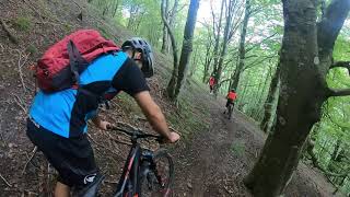
Sendero que discurre junto al río Basakaitz, de ahí su nombre, que podría entenderse como Basoko Haitza (Roca del bosque) o Basoko Gaitza (Enfermedad del bosque). Más de 5 km de sendero natural, empleado por nuestros antepasados y que guarda numerosas historias.

Comenzamos a bajar por un sendero pedregoso a través de una sucesión de zonas rápidas y curvas cerradas. El sendero permite coger mucha velocidad, pero con control, ya que a nuestro lado tendremos una buena caída por una hayedo de laderas muy inclinadas. A medida que bajamos, el terreno se vuelve más blando, con un agarre bestial en la mayoría de condiciones, aumentando la frecuencia de las curvas.

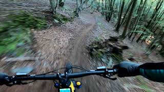
Llegados al punto en el que estamos encima del río, vuelta a tramos rápidos de soltar freno, hasta que vuelve a un terreno pedregoso. Nos esperan más de 2 km de piedra, con una tendencia de bajada, pero que tendremos que apretar en algunos tramos de subida.

Sendero exigente, pero espectacular, atravesando el cañón del río con un paisaje impresionante. Como broche final, merendero y pequeña zona de descanso a la salida del sendero, para terminar con un recorrido de 5 estrellas.

Disclaimer

En invierno hay zonas en las que se acumula mucha hoja, y es una zona en la que es frecuente la caída de árboles.

Trail Supporters
Local Trail Association

Recent Activity on Trail

Past Week
  • 3 rides
  • 17 miles average
6 Months
  • 9 rides
  • 20 miles avg distance
All
  • 43 rides
  • Last: Jun 16, 2026
c1c2c3c4
January
February
March
April
May
June
July
August
September
October
November
December
update trails status or condition

Basakaitz Trail Reports

statusdatedescription
Apr 11, 2026 @ 1:45am (Europe/Madrid)
Apr 10, 2026
Las motos han hecho de las suyas, han reventado partes, abierto tiradas rectas, y abierto surco en otros. De hecho me he cruzado con una moto, me...
Jan 5, 2026 @ 8:25am (Europe/Madrid)
Jan 4, 2026
Algun que otro arbol pequeño caido, se pueden sortear sin problema. Ramas caidas y hojas por tramos. Disfrutable!
Nov 24, 2025 @ 9:25pm (Europe/Madrid)
Nov 24, 2025
reporter
Nov 9, 2025 @ 7:02pm (Europe/Madrid)
Nov 9, 2025
La mayor parte del sendero es una línea recta sin apenas obstáculos (estaría bien una subida suave, jaja). La parte baja tiene rocas...
Sep 19, 2025 @ 10:16am (America/Vancouver)
Sep 19, 2025
Todo correcto!! Se sigue todo bastante bien y no hay ramas ni nada que te impidan pasar. Yo labhe bajado del tirón sin complicaciones
more »
Status:
on Apr 11, 2026
Ideal
Avg: 4.26 (10 votes)
Your vote: 0

view (145)
close
3D
Trail Conditions
  • Unknown
  • Snow Groomed
  • Snow Packed
  • Snow Covered
  • Snow Cover Partial
  • Freeze/thaw Cycle
  • Icy
  • Prevalent Mud
  • Wet
  • Variable
  • Ideal
  • Dry
  • Very Dry
Trail Flow (Ridden Direction)
Trailforks scans users ridelogs to determine the most popular direction each trail is ridden. A good flowing trail network will have most trails flowing in a single direction according to their intension.
The colour categories are based on what percentage of riders are riding a trail in its intended direction.
  • > 96%
  • > 90%
  • > 80%
  • > 70%
  • > 50%
  • < 50%
  • bi-directional trail
  • no data
Trail Last Ridden
Trailforks scans ridelogs to determine the last time a trail was ridden.
  • < 2 days
  • < 1 week
  • < 2 weeks
  • < 1 month
  • < 6 months
  • > 6 months
Trail Ridden Direction
The intended direction a trail should be ridden.
  • Downhill Only
  • Downhill Primary
  • Both Directions
  • Uphill Primary
  • Uphill Only
  • One Direction
Contribute Details
Colors indicate trail is missing specified detail.
  • Description
  • Photos
  • Description & Photos
  • Videos
Trail Popularity ?
Trailforks scans ridelogs to determine which trails are ridden the most in the last 9 months. Trails are compared with nearby trails in the same city region with a possible 25 colour shades. Think of this as a heatmap, more rides = more kinetic energy = warmer colors.
  • most popular
  • popular
  • less popular
  • not popular
ATV/ORV/OHV Filter
Max Vehicle Width
inches
US Cell Coverage
Legend
cell carrier legend

Radar Time
Activity Recordings
Trailforks uses anonymized public activity data. ?
Activity Recordings
Trailforks uses anonymized public activity data. ?
Personal Heatmap
Activity Types
all / none
Options
2
Date range month
Winter Trails
Warning A routing network for winter maps does not exist. Selecting trails using the winter trails layer has been disabled.
Missing Trails
Most Popular
Least Popular
Trails are colored based on popularity. The more popular a trail is, the more red. Less popular trails trend towards green.
Jump Magnitude Heatmap
Heatmap of where riders jump on trails. Zoom in to see individual jumps, click circles to view jump details.
BC Backroad Status

Service Road Atlas is a free to use, community-driven service for viewing and creating reports on the numerous back-country service roads around B.C. and Alberta.

map legend
Slope Aspect
Direction the slope faces
Flat N NE E SE S SW W NW
Trails Deemphasized
Trails are shown in grey.
disable
Only show trails with no bike usage.
Enable
Suggested Layers
Based on selected activity type

    Save the current map location and zoom level as your default home location whenever this page is loaded.

    Save
        Directions to basakaitz trailhead (43.064430, -1.848640)

        Photos

        8 more »
        51 |
        Nov 11, 2022 @ 1:28pm
        Nov 11, 2022
        61 |
        Nov 11, 2022 @ 1:28pm
        Nov 11, 2022
        65 |
        Nov 11, 2022 @ 1:28pm
        Nov 11, 2022
        60 |
        Nov 11, 2022 @ 1:28pm
        Nov 11, 2022

        Videos

        3 more »
        R01. Jaiotze Basatia. Nacimiento salvaje MTB...
        0:35 | 137 | Mar 24, 2023 , Lekunberri
        Beruete II: Basakaitz
        20:01 | 327 | Jan 3, 2022 , Lekunberri
        BERUETE MTB Basakaitz
        3:06 | 312 | Jan 3, 2022 , Lekunberri

        Routes with this trail

        5.0 25 miles 6,934 ft 31 Loop
        de , (Nacimiento salvaje) que une los pueblos de , y a través de un recorrido salvaje, convirtiéndolo en...

        4 Reviews & Comments


        We hope you've been enjoying Trailforks!

        Create a FREE account to view trail comments and much more.

        Frequently Asked Questions About Basakaitz

        Where is Basakaitz located?
        Basakaitz is located in Basaburua, Lekunberri, Spain. It is part of the Basaburua trail network. The trailhead is located at coordinates 43.06443, -1.84864.
        How hard is Basakaitz?
        Basakaitz is rated as Red difficulty. The physical rating is Hard. The average grade is 12.4%.
        What is the elevation gain for Basakaitz?
        Basakaitz has 15 m of elevation gain. The trail has 649 m of elevation descent. The elevation ranges from 433 m to 1,067 m.
        Is Basakaitz a point to point trail?
        Basakaitz is not a point to point trail. The direction is Downhill Primary. The trail type is singletrack.

        Hit the Trail

        Open in App

        Get this trail on your phone instantly.
        open trail in app

        Download Trail

        Save to wishlist, Garmin & download.
        save the trail

        Find Related Routes

        Find routes and users activities that include this trail.
        find routes for this trail

        You must enter a description before submitting.