more stats
3,684 ft
Distance
11 ft
Climb
-475 ft
Descent
00:04:37
Avg time
-464 ft
Altitude change
2,404 ft
Altitude min
2,868 ft
Altitude max
2,868 ft
Altitude start
2,405 ft
Altitude end
-12.6%
Grade
-39.3%
Grade max
9.2%
Grade min
121 ft
Distance climb
3,566 ft
Distance down
00:04:37
Avg time

Trail Details

  • Activities
    • Mountain Bike
    • E-Bike
  • Riding Area
  • Ref Number
    #2
  • Difficulty Rating
  • Local Popularity
    90 in Mountain Biking [+]
    • 100 in E-Biking
  • Global Ranking
    #52512 in Mountain Biking [+]
    • #5417 in E-Biking
  • Trail Type
    Singletrack
  • Bike Type
    DH, AM
  • Direction
    Downhill Only
    Popular Direction Shown
  • Physical Rating
    Moderate
  • Season
    Apr-Nov
  • Dogs Allowed
    Yes
  • eBike Allowed
  • TTFs on Trail
    Bridge, Jump, Roller Coaster
  • Year Opened
    2014
  • Land Owner
    Красная Поляна

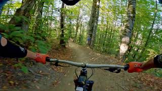
«Медвежий угол», вместе со стартовым отрезком «Бухты» (до моста-развилки), был проложен одним из первых, и довольно сильно отличается по стилю от более поздних трасс. По сути, на примере «Медвежьего угла» мы знакомились с особенностями местного грунта и водоносными горизонтами. Которые здесь таковы, что льется чуть ли не из каждого угла. В самом начале трассы, к примеру, протекает стенка метров 20 в длину. Забрав все эти выходы грунтовых вод в три трубы, мы создали место, получившее название «Три ручья» — по сути, три родника, из которых вполне можно пить — никто из строителей за время стройки не испытал каких-либо проблем с водой из эти родников.

source: 26.ru
Trail Supporters
  • past supporters

  • Trailworx Co, Ltd
    2014
    Builder

Bike Park

Recent Activity on Trail

Past Week
  • 0 rides
  •  
6 Months
  • 0 rides
  •  
All
  • 40 rides
  • Last: May 5, 2026
c1c2c3c4
January
February
March
April
May
June
July
August
September
October
November
December
update trails status or condition

Медвежий... Trail Reports

Status:
on Mar 31, 2024
Avg: 4.32 (3 votes)
Your vote: 0

view (1,038)
close
3D
Trail Conditions
  • Unknown
  • Snow Groomed
  • Snow Packed
  • Snow Covered
  • Snow Cover Partial
  • Freeze/thaw Cycle
  • Icy
  • Prevalent Mud
  • Wet
  • Variable
  • Ideal
  • Dry
  • Very Dry
Trail Flow (Ridden Direction)
Trailforks scans users ridelogs to determine the most popular direction each trail is ridden. A good flowing trail network will have most trails flowing in a single direction according to their intension.
The colour categories are based on what percentage of riders are riding a trail in its intended direction.
  • > 96%
  • > 90%
  • > 80%
  • > 70%
  • > 50%
  • < 50%
  • bi-directional trail
  • no data
Trail Last Ridden
Trailforks scans ridelogs to determine the last time a trail was ridden.
  • < 2 days
  • < 1 week
  • < 2 weeks
  • < 1 month
  • < 6 months
  • > 6 months
Trail Ridden Direction
The intended direction a trail should be ridden.
  • Downhill Only
  • Downhill Primary
  • Both Directions
  • Uphill Primary
  • Uphill Only
  • One Direction
Contribute Details
Colors indicate trail is missing specified detail.
  • Description
  • Photos
  • Description & Photos
  • Videos
Trail Popularity ?
Trailforks scans ridelogs to determine which trails are ridden the most in the last 9 months. Trails are compared with nearby trails in the same city region with a possible 25 colour shades. Think of this as a heatmap, more rides = more kinetic energy = warmer colors.
  • most popular
  • popular
  • less popular
  • not popular
ATV/ORV/OHV Filter
Max Vehicle Width
inches
US Cell Coverage
Legend
cell carrier legend

Radar Time
Activity Recordings
Trailforks uses anonymized public activity data. ?
Activity Recordings
Trailforks uses anonymized public activity data. ?
Personal Heatmap
Activity Types
all / none
Options
2
Date range month
Winter Trails
Warning A routing network for winter maps does not exist. Selecting trails using the winter trails layer has been disabled.
Missing Trails
Most Popular
Least Popular
Trails are colored based on popularity. The more popular a trail is, the more red. Less popular trails trend towards green.
Jump Magnitude Heatmap
Heatmap of where riders jump on trails. Zoom in to see individual jumps, click circles to view jump details.
BC Backroad Status

Service Road Atlas is a free to use, community-driven service for viewing and creating reports on the numerous back-country service roads around B.C. and Alberta.

map legend
Slope Aspect
Direction the slope faces
Flat N NE E SE S SW W NW
Trails Deemphasized
Trails are shown in grey.
disable
Only show trails with no bike usage.
Enable
Suggested Layers
Based on selected activity type

    Save the current map location and zoom level as your default home location whenever this page is loaded.

    Save
        Directions to bear-corner trailhead (43.672280, 40.260270)

        Photos

        15 more »
        213 |
        Sep 10, 2014 @ 8:41am
        Sep 10, 2014
        180 |
        Aug 15, 2014 @ 9:50am
        Aug 15, 2014
        163 |
        Sep 10, 2014 @ 8:41am
        Sep 10, 2014
        156 |
        Sep 10, 2014 @ 8:41am
        Sep 10, 2014

        Videos

        3 more »
        Горки Байкпарк - Медвежий...
        4:17 | 154 | Oct 23, 2020 , Sochi
        Roll All Day Spot Party, ep. 1. Green Line,...
        919 | Aug 16, 2014 , Sochi
        Anzor Shukhov in Gorki Bikepark, special for...
        2:45 | 740 | Aug 15, 2014 , Sochi

        Reviews / Comments

        No reviews yet, be the first to write a review or ask a question.
        Use trail reports to comment on trail conditions.


        We hope you've been enjoying Trailforks!

        Create a FREE account to view trail comments and much more.

        • By DrumminMan TBRU & contributors
        • #7696 - 2,570 views

        Frequently Asked Questions About Медвежий угол | Bear Corner

        Where is Медвежий угол | Bear Corner located?
        Медвежий угол | Bear Corner is located in Байкпарк "Красная поляна", Sochi, Russia. It is part of the Байкпарк "Красная поляна" trail network. The trailhead is located at coordinates 43.67228, 40.26027.
        How hard is Медвежий угол | Bear Corner?
        Медвежий угол | Bear Corner is rated as Blue difficulty. The physical rating is Moderate. The average grade is 12.6%.
        What is the elevation gain for Медвежий угол | Bear Corner?
        Медвежий угол | Bear Corner has 11 ft of elevation gain. The trail has 475 ft of elevation descent. The elevation ranges from 2,404 ft to 2,868 ft.
        Is Медвежий угол | Bear Corner a point to point trail?
        Yes, Медвежий угол | Bear Corner is a point to point trail. The direction is Downhill Only. The trail type is singletrack.

        Hit the Trail

        Open in App

        Get this trail on your phone instantly.
        open trail in app

        Download Trail

        Save to wishlist, Garmin & download.
        save the trail

        Find Related Routes

        Find routes and users activities that include this trail.
        find routes for this trail

        You must enter a description before submitting.