more stats
1.2 miles
Distance
408 ft
Climb
-7 ft
Descent
00:21:09
Avg time
401 ft
Altitude change
4,267 ft
Altitude min
4,670 ft
Altitude max
4,269 ft
Altitude start
4,672 ft
Altitude end
6.6%
Grade
-5.1%
Grade max
28.5%
Grade min
1 mile
Distance climb
348 ft
Distance down
279 ft
Distance flat
00:21:09
Avg time

Bebop Details

  • Activities
    • Mountain Bike
    • E-Bike
    • Winter Fat Bike
    • Hike
    • Trail Running
    • Snowshoe
  • Riding Area
    Teenage Mutant Ninja Turtles Network
    Elkford, British Columbia
  • Difficulty Rating
  • Local Popularity
    100 in Mountain Biking [+]
    • 100 in E-Biking
    • 90 in Trail Running
    • 90 in Hiking
    • 100 in Snowshoeing
  • Global Ranking
    #2243 in Mountain Biking [+]
    • #13316 in E-Biking
    • #254580 in Trail Running
    • #47546 in Hiking
    • #381 in Snowshoeing
  • Hiking SAC Scale
    T1 Hiking
  • Trail Type
    Singletrack
  • Snow Grooming
    Groomed Smooth
  • Bike Type
    DH, AM, XC, Fat
  • Climb Difficulty
    Blue
  • Physical Rating
    Moderate
  • Trail Visibility
    Always easy to follow
  • Season
    4 season - Winter Groomed
  • Family Friendly
    Yes
  • Dogs Allowed
    Yes
  • eBike Allowed
  • TTFs on Trail
    Berm
  • Year Opened
    2022

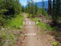
Built by Elkford Trails Alliance in 2022. Addition to the Teenage Mutant Ninja Turtle trail network. Part of the easiest up option to Lost lake. Built for multi-directional 4-season non-motorized use. Great views, destination and loop options.

Trail Supporters
  • Backcountry Trail Experts
    Builder
Local Trail Association
Traditionally Indigenous Territory

Recent Activity on Trail

Past Week
  • 3 rides
  • 6 miles average
6 Months
  • 27 rides
  • 10 miles avg distance
All
  • 174 rides
  • Last: Jun 29, 2026
c1c2c3c4
January
February
March
April
May
June
July
August
September
October
November
December
update trails status or condition

Bebop Trail Reports

statusdatedescription
May 9, 2026 @ 2:26pm (America/Edmonton)
May 9, 2026
reporter Good shape. Good to go.
Apr 28, 2026 @ 5:51pm (America/Edmonton)
Apr 28, 2026
Mostly dry, with some snow patches left near the top
Mar 1, 2026 @ 9:19pm (America/Edmonton)
Mar 1, 2026
reporter Corduroy laid today. Trail is in great shape.
Feb 26, 2026 @ 9:14am (America/Edmonton)
Feb 26, 2026
reporter Groomed Feb 24th. Was a damp 25 cm of snow that has been packed down. Should set nicely for cold temp riding.
Feb 23, 2026 @ 12:31pm (America/Edmonton)
Feb 23, 2026
reporter a new 20 cm arrived last night. Snow covered. Snowshoes will bring the trails around nicely with the moist layer of snow.
more »
Status:
on May 9, 2026
Ideal
Avg: 4.09 (4 votes)
Your vote: 0

view (875)
close
3D
Trail Conditions
  • Unknown
  • Snow Groomed
  • Snow Packed
  • Snow Covered
  • Snow Cover Partial
  • Freeze/thaw Cycle
  • Icy
  • Prevalent Mud
  • Wet
  • Variable
  • Ideal
  • Dry
  • Very Dry
Trail Flow (Ridden Direction)
Trailforks scans users ridelogs to determine the most popular direction each trail is ridden. A good flowing trail network will have most trails flowing in a single direction according to their intension.
The colour categories are based on what percentage of riders are riding a trail in its intended direction.
  • > 96%
  • > 90%
  • > 80%
  • > 70%
  • > 50%
  • < 50%
  • bi-directional trail
  • no data
Trail Last Ridden
Trailforks scans ridelogs to determine the last time a trail was ridden.
  • < 2 days
  • < 1 week
  • < 2 weeks
  • < 1 month
  • < 6 months
  • > 6 months
Trail Ridden Direction
The intended direction a trail should be ridden.
  • Downhill Only
  • Downhill Primary
  • Both Directions
  • Uphill Primary
  • Uphill Only
  • One Direction
Contribute Details
Colors indicate trail is missing specified detail.
  • Description
  • Photos
  • Description & Photos
  • Videos
Trail Popularity ?
Trailforks scans ridelogs to determine which trails are ridden the most in the last 9 months. Trails are compared with nearby trails in the same city region with a possible 25 colour shades. Think of this as a heatmap, more rides = more kinetic energy = warmer colors.
  • most popular
  • popular
  • less popular
  • not popular
ATV/ORV/OHV Filter
Max Vehicle Width
inches
US Cell Coverage
Legend
cell carrier legend

Radar Time
Activity Recordings
Trailforks uses anonymized public activity data. ?
Activity Recordings
Trailforks uses anonymized public activity data. ?
Personal Heatmap
Activity Types
all / none
Options
2
Date range month
Winter Trails
Warning A routing network for winter maps does not exist. Selecting trails using the winter trails layer has been disabled.
Missing Trails
Most Popular
Least Popular
Trails are colored based on popularity. The more popular a trail is, the more red. Less popular trails trend towards green.
Jump Magnitude Heatmap
Heatmap of where riders jump on trails. Zoom in to see individual jumps, click circles to view jump details.
BC Backroad Status

Service Road Atlas is a free to use, community-driven service for viewing and creating reports on the numerous back-country service roads around B.C. and Alberta.

map legend
Slope Aspect
Direction the slope faces
Flat N NE E SE S SW W NW
Trails Deemphasized
Trails are shown in grey.
disable
Only show trails with no bike usage.
Enable
Suggested Layers
Based on selected activity type

    Save the current map location and zoom level as your default home location whenever this page is loaded.

    Save
        Directions to bebop trailhead (50.010690, -114.909390)

        Photos

        6 more »
        98 |
        Oct 15, 2022 @ 6:30pm
        Oct 15, 2022
        85 |
        Oct 9, 2022 @ 8:06pm
        Oct 9, 2022
        76 |
        Oct 9, 2022 @ 8:05pm
        Oct 9, 2022
        103 |
        Oct 9, 2022 @ 8:05pm
        Oct 9, 2022

        Videos

        1 more »
        Elkford Mountain biking | Bebop
        4:31 | 162 | May 30, 2023 , Elkford

        Trail Lists

        Routes with this trail

        5.0 8 miles 1,380 ft 7 Loop
        This trail is groomed for winter fat biking. It a fun and rewarding loop. Could be done in the summer as...
        5 miles 855 ft 5
        Join us September 27th @1:30 for a fun fundraising event with prizes!
        3 miles 711 ft 1 Loop
        This is the fastest and funniest route on the Teenage Mutant Ninja Turtles. Nice climb and fast descent.

        1 Review & Comments


        We hope you've been enjoying Trailforks!

        Create a FREE account to view trail comments and much more.

        • By colinsv0bTF Pro ETA & contributors
        • #571831 - 1,045 views

        Frequently Asked Questions About Bebop

        Where is Bebop located?
        Bebop is located in Teenage Mutant Ninja Turtles Network, Elkford, British Columbia, Canada. It is part of the Teenage Mutant Ninja Turtles Network trail network. The trailhead is located at coordinates 50.01069, -114.90939.
        How hard is Bebop?
        Bebop is rated as Green difficulty. The physical rating is Moderate. The average grade is 6.6%. The climb difficulty is rated Blue.
        What is the elevation gain for Bebop?
        Bebop has 408 ft of elevation gain. The trail has 7 ft of elevation descent. The elevation ranges from 4,267 ft to 4,670 ft.
        How long is Bebop?
        Bebop is 1.2 miles long. The trail type is singletrack.

        Hit the Trail

        Open in App

        Get this trail on your phone instantly.
        open trail in app

        Download Trail

        Save to wishlist, Garmin & download.
        save the trail

        Find Related Routes

        Find routes and users activities that include this trail.
        find routes for this trail

        You must enter a description before submitting.