more stats
3,865 ft
Distance
-390 ft
Descent
00:16:46
Avg time
-390 ft
Altitude change
2,055 ft
Altitude min
2,447 ft
Altitude max
2,445 ft
Altitude start
2,057 ft
Altitude end
-10.1%
Grade
-65.3%
Grade max
1.6%
Grade min
325 ft
Distance climb
3,419 ft
Distance down
121 ft
Distance flat
00:16:46
Avg time

Bedea Flow Details

  • Activities
    • Mountain Bike
    • E-Bike
  • Riding Area
  • Difficulty Rating
  • Local Popularity
    70 in Mountain Biking [+]
    • 70 in E-Biking
  • Global Ranking
    #75072 in Mountain Biking [+]
    • #48118 in E-Biking
  • Trail Type
    Singletrack
  • Bike Type
    AM, XC
  • Direction
    Downhill Only[+]
    Popular Direction Shown
    • Downhill Only for E-Biking
  • Climb Difficulty
    Blue
  • Physical Rating
    Easy
  • Trail Visibility
    Always easy to follow
  • Season
    All
  • Family Friendly
    Yes
  • eBike Allowed
    Yes up to Class 1
  • TTFs on Trail
    Berm
  • Ride in Rain
    Yes
  • Year Opened
    2019

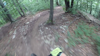
Flow trail with berms. Good flow and trail conditions allow it to be fun on any bike XC, Enduro or even DH. The fireroad is used to pedal to the top easily.
Unfortunately no jumps or tabletops

Access Info

In via Lema, turn right at the cemetery, and pedal up towards the top of the hill. Once in the fireroad, at the barrier, turn right for the XC uphill trail, or continue straight up the fireroad.

Recent Activity on Trail

Past Week
  • 1 rides
  • 12 miles average
6 Months
  • 8 rides
  • 18 miles avg distance
All
  • 23 rides
  • Last: May 27, 2026
c1c2c3c4
January
February
March
April
May
June
July
August
September
October
November
December
update trails status or condition

Bedea Flow Trail Reports

Status:
on Jan 25, 2026
Wet
Avg: 4.07 (7 votes)
Your vote: 0

view (133)
close
3D
Trail Conditions
  • Unknown
  • Snow Groomed
  • Snow Packed
  • Snow Covered
  • Snow Cover Partial
  • Freeze/thaw Cycle
  • Icy
  • Prevalent Mud
  • Wet
  • Variable
  • Ideal
  • Dry
  • Very Dry
Trail Flow (Ridden Direction)
Trailforks scans users ridelogs to determine the most popular direction each trail is ridden. A good flowing trail network will have most trails flowing in a single direction according to their intension.
The colour categories are based on what percentage of riders are riding a trail in its intended direction.
  • > 96%
  • > 90%
  • > 80%
  • > 70%
  • > 50%
  • < 50%
  • bi-directional trail
  • no data
Trail Last Ridden
Trailforks scans ridelogs to determine the last time a trail was ridden.
  • < 2 days
  • < 1 week
  • < 2 weeks
  • < 1 month
  • < 6 months
  • > 6 months
Trail Ridden Direction
The intended direction a trail should be ridden.
  • Downhill Only
  • Downhill Primary
  • Both Directions
  • Uphill Primary
  • Uphill Only
  • One Direction
Contribute Details
Colors indicate trail is missing specified detail.
  • Description
  • Photos
  • Description & Photos
  • Videos
Trail Popularity ?
Trailforks scans ridelogs to determine which trails are ridden the most in the last 9 months. Trails are compared with nearby trails in the same city region with a possible 25 colour shades. Think of this as a heatmap, more rides = more kinetic energy = warmer colors.
  • most popular
  • popular
  • less popular
  • not popular
ATV/ORV/OHV Filter
Max Vehicle Width
inches
US Cell Coverage
Legend
cell carrier legend

Radar Time
Activity Recordings
Trailforks uses anonymized public activity data. ?
Activity Recordings
Trailforks uses anonymized public activity data. ?
Personal Heatmap
Activity Types
all / none
Options
2
Date range month
Winter Trails
Warning A routing network for winter maps does not exist. Selecting trails using the winter trails layer has been disabled.
Missing Trails
Most Popular
Least Popular
Trails are colored based on popularity. The more popular a trail is, the more red. Less popular trails trend towards green.
Jump Magnitude Heatmap
Heatmap of where riders jump on trails. Zoom in to see individual jumps, click circles to view jump details.
BC Backroad Status

Service Road Atlas is a free to use, community-driven service for viewing and creating reports on the numerous back-country service roads around B.C. and Alberta.

map legend
Slope Aspect
Direction the slope faces
Flat N NE E SE S SW W NW
Trails Deemphasized
Trails are shown in grey.
disable
Only show trails with no bike usage.
Enable
Suggested Layers
Based on selected activity type

    Save the current map location and zoom level as your default home location whenever this page is loaded.

    Save
        Directions to bedea-flow trailhead (46.006400, 8.864760)

        Photos

        3 more »
        28 |
        Dec 7, 2025 @ 1:14pm
        Dec 7, 2025
        34 |
        Dec 7, 2025 @ 1:12pm
        Dec 7, 2025
        149 |
        Aug 25, 2020 @ 12:45pm
        Aug 25, 2020

        Videos

        1 more »
        Bedea Flow
        3:49 | 340 | Aug 1, 2019 , Novaggio

        4 Reviews & Comments


        We hope you've been enjoying Trailforks!

        Create a FREE account to view trail comments and much more.

        • By ramcrew & contributors
        • #203992 - 2,570 views

        Frequently Asked Questions About Bedea Flow

        Where is Bedea Flow located?
        Bedea Flow is located in Novaggio, Switzerland. It is part of the Novaggio trail network. The trailhead is located at coordinates 46.0064, 8.86476.
        How hard is Bedea Flow?
        Bedea Flow is rated as Blue difficulty. The physical rating is Easy. The average grade is 10.1%. The climb difficulty is rated Blue.
        What is the elevation gain for Bedea Flow?
        The trail has 390 ft of elevation descent. The elevation ranges from 2,055 ft to 2,447 ft.
        Is Bedea Flow a point to point trail?
        Yes, Bedea Flow is a point to point trail. The direction is Downhill Only. The trail type is singletrack.

        Hit the Trail

        Open in App

        Get this trail on your phone instantly.
        open trail in app

        Download Trail

        Save to wishlist, Garmin & download.
        save the trail

        Find Related Routes

        Find routes and users activities that include this trail.
        find routes for this trail

        You must enter a description before submitting.