more stats
591 ft
Distance
-111 ft
Descent
00:01:28
Avg time
-111 ft
Altitude change
4,738 ft
Altitude min
4,849 ft
Altitude max
4,849 ft
Altitude start
4,738 ft
Altitude end
-18.85%
Grade
-48.09%
Grade max
0.238%
Grade min
494 ft
Distance down
97 ft
Distance flat
00:01:28
Avg time

Bentonite Details

  • Activities
    • Mountain Bike
    • Hike
    • Trail Running
  • Riding Area
    Lunch Loops
    Grand Junction, Colorado
  • Difficulty Rating
  • Voted Difficulty
    Double Black Diamond (1 vote)
  • Local Popularity
    85 in Mountain Biking [+]
    • 85 in Trail Running
    • 90 in Hiking
  • Global Ranking
    #64249 in Mountain Biking [+]
    • #55097 in Trail Running
    • #47247 in Hiking
  • Trail Type
    Singletrack
  • Direction
    Downhill Primary
    Popular Direction Shown
  • Dogs Allowed
    Yes
  • eBike Allowed
  • Land Owner
    Grand Junction Field Office of the BLM

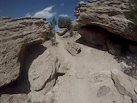
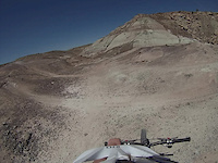
Bentonite provides an alternative descent from the rim to the Tabagauche trail. It is an exposed single-track trail that skirts along the top and down the side of a mineral-heavy hill. Connects into Moto and is a playground for riders looking for fast, fun and flow.

Trail Supporters
  • BLM
    BLM
    Land Manager
Local Trail Association
Traditionally Indigenous Territory

Recent Activity on Trail

Past Week
  • 2 rides
  • 10 miles average
6 Months
  • 64 rides
  • 9 miles avg distance
All
  • 520 rides
  • Last: Jun 30, 2026
c1c2c3c4
January
February
March
April
May
June
July
August
September
October
November
December
Status:
on Dec 10, 2025
Variable
Avg: 3.66 (9 votes)
Your vote: 0

view (4,923)
close
3D
Trail Conditions
  • Unknown
  • Snow Groomed
  • Snow Packed
  • Snow Covered
  • Snow Cover Partial
  • Freeze/thaw Cycle
  • Icy
  • Prevalent Mud
  • Wet
  • Variable
  • Ideal
  • Dry
  • Very Dry
Trail Flow (Ridden Direction)
Trailforks scans users ridelogs to determine the most popular direction each trail is ridden. A good flowing trail network will have most trails flowing in a single direction according to their intension.
The colour categories are based on what percentage of riders are riding a trail in its intended direction.
  • > 96%
  • > 90%
  • > 80%
  • > 70%
  • > 50%
  • < 50%
  • bi-directional trail
  • no data
Trail Last Ridden
Trailforks scans ridelogs to determine the last time a trail was ridden.
  • < 2 days
  • < 1 week
  • < 2 weeks
  • < 1 month
  • < 6 months
  • > 6 months
Trail Ridden Direction
The intended direction a trail should be ridden.
  • Downhill Only
  • Downhill Primary
  • Both Directions
  • Uphill Primary
  • Uphill Only
  • One Direction
Contribute Details
Colors indicate trail is missing specified detail.
  • Description
  • Photos
  • Description & Photos
  • Videos
Trail Popularity ?
Trailforks scans ridelogs to determine which trails are ridden the most in the last 9 months. Trails are compared with nearby trails in the same city region with a possible 25 colour shades. Think of this as a heatmap, more rides = more kinetic energy = warmer colors.
  • most popular
  • popular
  • less popular
  • not popular
ATV/ORV/OHV Filter
Max Vehicle Width
inches
US Cell Coverage
Legend
cell carrier legend

Radar Time
Activity Recordings
Trailforks uses anonymized public activity data. ?
Activity Recordings
Trailforks uses anonymized public activity data. ?
Personal Heatmap
Activity Types
all / none
Options
2
Date range month
Winter Trails
Warning A routing network for winter maps does not exist. Selecting trails using the winter trails layer has been disabled.
Missing Trails
Most Popular
Least Popular
Trails are colored based on popularity. The more popular a trail is, the more red. Less popular trails trend towards green.
Jump Magnitude Heatmap
Heatmap of where riders jump on trails. Zoom in to see individual jumps, click circles to view jump details.
BC Backroad Status

Service Road Atlas is a free to use, community-driven service for viewing and creating reports on the numerous back-country service roads around B.C. and Alberta.

map legend
Slope Aspect
Direction the slope faces
Flat N NE E SE S SW W NW
Trails Deemphasized
Trails are shown in grey.
disable
Only show trails with no bike usage.
Enable
Suggested Layers
Based on selected activity type

    Save the current map location and zoom level as your default home location whenever this page is loaded.

    Save
        Directions to bentonite trailhead (39.044000, -108.604410)

        Photos

        5 more »
        284 |
        Jan 22, 2018 @ 5:00pm
        Jan 22, 2018
        240 |
        Jan 22, 2018 @ 5:00pm
        Jan 22, 2018
        787 |
        Aug 2, 2013 @ 8:00pm
        Aug 2, 2013
        607 |
        Mar 29, 2014 @ 12:04pm
        Mar 29, 2014

        Videos

        2 more »
        GoPro Tabeguache-High Noon and Moto.
        8:35 | 283 | Jun 2, 2013 , Grand Junction
        GoPro Tabeguache-Bentonite Hill
        0:56 | 214 | May 26, 2013 , Grand Junction

        Routes with this trail

        2.0 23 miles 3,293 ft 37
        LUNCH LOOPS FROM MONUMENT PARKING

        1 Review & Comments


        We hope you've been enjoying Trailforks!

        Create a FREE account to view trail comments and much more.

        • By toddTF Pro Trailforks & contributors
        • #12133 - 2,803 views

        Frequently Asked Questions About Bentonite

        Where is Bentonite located?
        Bentonite is located in Lunch Loops, Grand Junction, Colorado, United States. It is part of the Lunch Loops trail network. The trailhead is located at coordinates 39.044, -108.60441.
        How hard is Bentonite?
        Bentonite is rated as Black Diamond difficulty. The average grade is 18.85%.
        What is the elevation gain for Bentonite?
        The trail has 111 ft of elevation descent. The elevation ranges from 4,738 ft to 4,849 ft.
        Is Bentonite a point to point trail?
        Bentonite is not a point to point trail. The direction is Downhill Primary. The trail type is singletrack.

        Hit the Trail

        Open in App

        Get this trail on your phone instantly.
        open trail in app

        Download Trail

        Save to wishlist, Garmin & download.
        save the trail

        Find Related Routes

        Find routes and users activities that include this trail.
        find routes for this trail

        You must enter a description before submitting.