more stats
2,267 ft
Distance
-165 ft
Descent
00:03:52
Avg time
-165 ft
Altitude change
5,161 ft
Altitude min
5,326 ft
Altitude max
5,326 ft
Altitude start
5,161 ft
Altitude end
-7.3%
Grade
-25.8%
Grade max
2.2%
Grade min
33 ft
Distance climb
2,080 ft
Distance down
151 ft
Distance flat
00:03:52
Avg time

Big Thunder Details

  • Activities
    • Mountain Bike
    • Hike
    • Trail Running
  • Riding Area
    Mountain Ranch Bike Park
    Eagle Mountain, Utah
  • Difficulty Rating
  • Voted Difficulty
    Black Diamond (1 vote)
  • Local Popularity
    85 in Mountain Biking [+]
    • 75 in Trail Running
    • 80 in Hiking
  • Global Ranking
    #32163 in Mountain Biking [+]
    • #48812 in Trail Running
    • #61849 in Hiking
  • Trail Type
    Singletrack
  • Direction
    Downhill Only
    Popular Direction Shown
  • Climb Difficulty
    Black Diamond
  • Physical Rating
    Hard
  • Dogs Allowed
    Yes

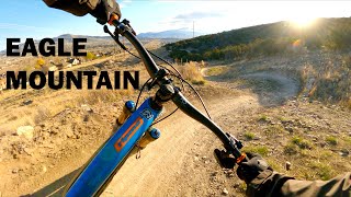
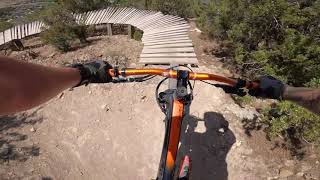
Probably the best section of trail on the Juniper hillside. Most trails cross back and for forth, but this has some great flow with cool structures and lots of rock kickers and little drop options.

Local Trail Association
Traditionally Indigenous Territory

Recent Activity on Trail

Past Week
  • 2 rides
  • 8 miles average
6 Months
  • 15 rides
  • 9 miles avg distance
All
  • 689 rides
  • Last: Jul 1, 2026
c1c2c3c4
January
February
March
April
May
June
July
August
September
October
November
December
update trails status or condition

Big Thunder Trail Reports

statusdatedescription
Mar 24, 2026 @ 4:47pm (America/Boise)
Mar 24, 2026
Mar 9, 2026 @ 10:50am (America/Denver)
Mar 9, 2026
Dec 20, 2025 @ 10:03am (America/Denver)
Dec 20, 2025
Perfect dirt but some of the wooden features could use some TLC
Nov 8, 2025 @ 10:58am (America/Boise)
Nov 8, 2025
May 21, 2025 @ 2:58pm
May 21, 2025
Broken wood/ttf structure. The wooden berms are missing planks. Still rideable but might throw someone off.
more »
Status:
on Mar 24, 2026
Dry
Avg: 4.53 (26 votes)
Your vote: 0

view (3,742)
close
3D
Trail Conditions
  • Unknown
  • Snow Groomed
  • Snow Packed
  • Snow Covered
  • Snow Cover Partial
  • Freeze/thaw Cycle
  • Icy
  • Prevalent Mud
  • Wet
  • Variable
  • Ideal
  • Dry
  • Very Dry
Trail Flow (Ridden Direction)
Trailforks scans users ridelogs to determine the most popular direction each trail is ridden. A good flowing trail network will have most trails flowing in a single direction according to their intension.
The colour categories are based on what percentage of riders are riding a trail in its intended direction.
  • > 96%
  • > 90%
  • > 80%
  • > 70%
  • > 50%
  • < 50%
  • bi-directional trail
  • no data
Trail Last Ridden
Trailforks scans ridelogs to determine the last time a trail was ridden.
  • < 2 days
  • < 1 week
  • < 2 weeks
  • < 1 month
  • < 6 months
  • > 6 months
Trail Ridden Direction
The intended direction a trail should be ridden.
  • Downhill Only
  • Downhill Primary
  • Both Directions
  • Uphill Primary
  • Uphill Only
  • One Direction
Contribute Details
Colors indicate trail is missing specified detail.
  • Description
  • Photos
  • Description & Photos
  • Videos
Trail Popularity ?
Trailforks scans ridelogs to determine which trails are ridden the most in the last 9 months. Trails are compared with nearby trails in the same city region with a possible 25 colour shades. Think of this as a heatmap, more rides = more kinetic energy = warmer colors.
  • most popular
  • popular
  • less popular
  • not popular
ATV/ORV/OHV Filter
Max Vehicle Width
inches
US Cell Coverage
Legend
cell carrier legend

Radar Time
Activity Recordings
Trailforks uses anonymized public activity data. ?
Activity Recordings
Trailforks uses anonymized public activity data. ?
Personal Heatmap
Activity Types
all / none
Options
2
Date range month
Winter Trails
Warning A routing network for winter maps does not exist. Selecting trails using the winter trails layer has been disabled.
Missing Trails
Most Popular
Least Popular
Trails are colored based on popularity. The more popular a trail is, the more red. Less popular trails trend towards green.
Jump Magnitude Heatmap
Heatmap of where riders jump on trails. Zoom in to see individual jumps, click circles to view jump details.
BC Backroad Status

Service Road Atlas is a free to use, community-driven service for viewing and creating reports on the numerous back-country service roads around B.C. and Alberta.

map legend
Slope Aspect
Direction the slope faces
Flat N NE E SE S SW W NW
Trails Deemphasized
Trails are shown in grey.
disable
Only show trails with no bike usage.
Enable
Suggested Layers
Based on selected activity type

    Save the current map location and zoom level as your default home location whenever this page is loaded.
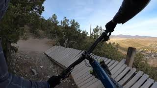
    Save
        Directions to big-thunder trailhead (40.349770, -111.980430)

        Photos

        19 more »
        98 |
        Jul 23, 2023 @ 8:52am
        Jul 23, 2023
        90 |
        Jul 23, 2023 @ 8:52am
        Jul 23, 2023
        93 |
        Jul 23, 2023 @ 8:51am
        Jul 23, 2023
        97 |
        Jul 23, 2023 @ 8:51am
        Jul 23, 2023

        Videos

        9 more »
        Best Route in Eagle Mountain | 4/19/2021
        11:32 | 534 | Apr 21, 2021 , Eagle Mountain
        Big Thunder - Eagle Mountain 2020
        8:12 | 370 | Nov 25, 2020 , Eagle Mountain
        “THAT trail” Eagle Mountain Bike Park
        2:16 | 475 | Aug 22, 2020 , Eagle Mountain
        BIG thunder
        2:50 | 365 | Jul 28, 2020 , Eagle Mountain

        Routes with this trail

        5.0 2 miles 186 ft 4
        I am new to creating routes, hopefully this works
        4.0 19 miles 2,652 ft 61 Loop
        I think this route hits all the highlights of Eagle Mountain. You do have to ride on the road for about a...
        29 miles 4,535 ft 32 Loop
        29 miles of cross country covering the majority of the popular trails in Eagle Mountain.

        4 Reviews & Comments


        We hope you've been enjoying Trailforks!

        Create a FREE account to view trail comments and much more.

        • By toddTF Pro Trailforks & contributors
        • #21831 - 6,430 views

        Frequently Asked Questions About Big Thunder

        Where is Big Thunder located?
        Big Thunder is located in Mountain Ranch Bike Park, Eagle Mountain, Utah, United States. It is part of the Mountain Ranch Bike Park trail network. The trailhead is located at coordinates 40.34977, -111.98043.
        How hard is Big Thunder?
        Big Thunder is rated as Black Diamond difficulty. The physical rating is Hard. The average grade is 7.3%. The climb difficulty is rated Black Diamond.
        What is the elevation gain for Big Thunder?
        The trail has 165 ft of elevation descent. The elevation ranges from 5,161 ft to 5,326 ft.
        Is Big Thunder a point to point trail?
        Yes, Big Thunder is a point to point trail. The direction is Downhill Only. The trail type is singletrack.

        Hit the Trail

        Open in App

        Get this trail on your phone instantly.
        open trail in app

        Download Trail

        Save to wishlist, Garmin & download.
        save the trail

        Find Related Routes

        Find routes and users activities that include this trail.
        find routes for this trail

        You must enter a description before submitting.