more stats
1.5 miles
Distance
51 ft
Climb
-398 ft
Descent
00:11:50
Avg time
-347 ft
Altitude change
3,014 ft
Altitude min
3,372 ft
Altitude max
3,360 ft
Altitude start
3,014 ft
Altitude end
-4.258%
Grade
-22.986%
Grade max
12.407%
Grade min
1,653 ft
Distance climb
1 mile
Distance down
715 ft
Distance flat
00:11:50
Avg time

Bipolar Details

  • Activities
    • Mountain Bike
    • Hike
    • Trail Running
  • Riding Area
    Southwest Ridge
    Las Vegas, Nevada
  • Difficulty Rating
  • Local Popularity
    90 in Mountain Biking [+]
    • 5 in Trail Running
    • 5 in Hiking
  • Global Ranking
    #26793 in Mountain Biking [+]
    • #129163 in Trail Running
    • #122184 in Hiking
  • Trail Type
    Singletrack
  • Bike Type
    AM, XC
  • Direction
    Downhill Primary
    Popular Direction Shown
  • Climb Difficulty
    Green
  • Physical Rating
    Moderate
  • Season
    All year
  • Dogs Allowed
    Yes
  • TTFs on Trail
    Drop, Rock Face
  • Year Opened
    2015

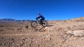
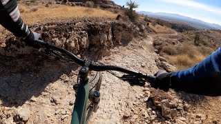
This trail starts off of Menny Thanks and heads down another finger. Starts out mellow and flowy but gets rowdier as you continue down. It's mostly an intermediate trail however there a number of large rock drops with the end of the trail having a long succession of drops. There are alternate ride around options for most of the larger drops.

This trail is unsanctioned.

Trail Supporters
  • BLM
    BLM
    Land Manager

Recent Activity on Trail

Past Week
  • 0 rides
  •  
6 Months
  • 34 rides
  • 9 miles avg distance
All
  • 494 rides
  • Last: Jun 24, 2026
c1c2c3c4
January
February
March
April
May
June
July
August
September
October
November
December
update trails status or condition

Bipolar Trail Reports

statusdatedescription
Mar 5, 2026 @ 5:31pm (America/Los_Angeles)
Mar 5, 2026
Trail is running great, drops are good, singletrack is clear, the chute at the end is pretty much perfect. My new favorite Vegas trail!
Mar 4, 2026 @ 11:35am (America/Los_Angeles)
Mar 4, 2026
Classic Southern NV dirt and rock
Nov 30, 2025 @ 1:48pm (America/Los_Angeles)
Nov 30, 2025
Dec 21, 2024 @ 11:01am
Dec 21, 2024
Dec 27, 2023 @ 11:05am
Dec 27, 2023
more »
Status:
on Mar 5, 2026
Ideal
Avg: 4.7 (27 votes)
Your vote: 0

view (2,821)
close
3D
Trail Conditions
  • Unknown
  • Snow Groomed
  • Snow Packed
  • Snow Covered
  • Snow Cover Partial
  • Freeze/thaw Cycle
  • Icy
  • Prevalent Mud
  • Wet
  • Variable
  • Ideal
  • Dry
  • Very Dry
Trail Flow (Ridden Direction)
Trailforks scans users ridelogs to determine the most popular direction each trail is ridden. A good flowing trail network will have most trails flowing in a single direction according to their intension.
The colour categories are based on what percentage of riders are riding a trail in its intended direction.
  • > 96%
  • > 90%
  • > 80%
  • > 70%
  • > 50%
  • < 50%
  • bi-directional trail
  • no data
Trail Last Ridden
Trailforks scans ridelogs to determine the last time a trail was ridden.
  • < 2 days
  • < 1 week
  • < 2 weeks
  • < 1 month
  • < 6 months
  • > 6 months
Trail Ridden Direction
The intended direction a trail should be ridden.
  • Downhill Only
  • Downhill Primary
  • Both Directions
  • Uphill Primary
  • Uphill Only
  • One Direction
Contribute Details
Colors indicate trail is missing specified detail.
  • Description
  • Photos
  • Description & Photos
  • Videos
Trail Popularity ?
Trailforks scans ridelogs to determine which trails are ridden the most in the last 9 months. Trails are compared with nearby trails in the same city region with a possible 25 colour shades. Think of this as a heatmap, more rides = more kinetic energy = warmer colors.
  • most popular
  • popular
  • less popular
  • not popular
ATV/ORV/OHV Filter
Max Vehicle Width
inches
US Cell Coverage
Legend
cell carrier legend

Radar Time
Activity Recordings
Trailforks uses anonymized public activity data. ?
Activity Recordings
Trailforks uses anonymized public activity data. ?
Personal Heatmap
Activity Types
all / none
Options
2
Date range month
Winter Trails
Warning A routing network for winter maps does not exist. Selecting trails using the winter trails layer has been disabled.
Missing Trails
Most Popular
Least Popular
Trails are colored based on popularity. The more popular a trail is, the more red. Less popular trails trend towards green.
Jump Magnitude Heatmap
Heatmap of where riders jump on trails. Zoom in to see individual jumps, click circles to view jump details.
BC Backroad Status

Service Road Atlas is a free to use, community-driven service for viewing and creating reports on the numerous back-country service roads around B.C. and Alberta.

map legend
Slope Aspect
Direction the slope faces
Flat N NE E SE S SW W NW
Trails Deemphasized
Trails are shown in grey.
disable
Only show trails with no bike usage.
Enable
Suggested Layers
Based on selected activity type

    Save the current map location and zoom level as your default home location whenever this page is loaded.

    Save
        Directions to bipolar trailhead (36.052681, -115.325621)

        Photos

        15 more »
        50 |
        Dec 6, 2025 @ 2:53pm
        Dec 6, 2025
        53 |
        Dec 6, 2025 @ 2:47pm
        Dec 6, 2025
        52 |
        Dec 6, 2025 @ 2:47pm
        Dec 6, 2025
        99 |
        Feb 27, 2024 @ 11:58am
        Feb 27, 2024

        Videos

        11 more »
        Good call to bipolar Mtb trail
        3:16 | 44 | Dec 6, 2025 , Las Vegas
        Bipolar
        8:58 | 202 | May 4, 2024 , Las Vegas
        youtuber Pure Fun Smashing Rocks on a Bike! | Mountain...
        26:18 | 147 | Mar 2, 2024 , Las Vegas
        Fear and Exposure in Las Vegas - Mountain...
        29:33 | 121 | Mar 2, 2024 , Las Vegas

        Routes with this trail

        11 miles 1,074 ft 3
        My favorite route through this system

        8 Reviews & Comments


        We hope you've been enjoying Trailforks!

        Create a FREE account to view trail comments and much more.

        • #39758 - 5,760 views

        Frequently Asked Questions About Bipolar

        Where is Bipolar located?
        Bipolar is located in Southwest Ridge, Las Vegas, Nevada, United States. It is part of the Southwest Ridge trail network. The trailhead is located at coordinates 36.05268, -115.32562.
        How hard is Bipolar?
        Bipolar is rated as Black Diamond difficulty. The physical rating is Moderate. The average grade is 4.258%. The climb difficulty is rated Green.
        What is the elevation gain for Bipolar?
        Bipolar has 51 ft of elevation gain. The trail has 398 ft of elevation descent. The elevation ranges from 3,014 ft to 3,372 ft.
        Is Bipolar a point to point trail?
        Bipolar is not a point to point trail. The direction is Downhill Primary. The trail type is singletrack.

        Hit the Trail

        Open in App

        Get this trail on your phone instantly.
        open trail in app

        Download Trail

        Save to wishlist, Garmin & download.
        save the trail

        Find Related Routes

        Find routes and users activities that include this trail.
        find routes for this trail

        You must enter a description before submitting.