more stats
1,056 ft
Distance
-252 ft
Descent
00:06:19
Avg time
-252 ft
Altitude change
5,152 ft
Altitude min
5,404 ft
Altitude max
5,404 ft
Altitude start
5,151 ft
Altitude end
-23.9%
Grade
-48.3%
Grade max
-13%
Grade min
1,056 ft
Distance down
00:06:19
Avg time

Black Bear Upper Details

  • Activities
    • Mountain Bike
  • Riding Area
    Beech Mountain Bike Park
    Beech Mountain, North Carolina
  • Difficulty Rating
  • Local Popularity
    35 in Mountain Biking
  • Global Ranking
    #110394 in Mountain Biking
  • Trail Type
    Singletrack
  • Bike Type
    DH
  • Direction
    Downhill Only
    Popular Direction Shown
  • Physical Rating
    Hard
  • Season
    When Open
  • eBike Allowed
  • TTFs on Trail
    Drop, Jump, Gap Jump, Rock Face, Rock Garden

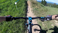
This is our DH race track. Countless National and local dh races have been held here. There have been several revisions and updates. The current update adds a few more turns to increase length and help with erosion.

Trail Supporters
  • past supporters

  • Cane Creek
    Sponsor

Bike Park

Recent Activity on Trail

Past Week
  • 0 rides
  •  
6 Months
  • 6 rides
  • 7 miles avg distance
All
  • 73 rides
  • Last: Jun 21, 2026
c1c2c3c4
January
February
March
April
May
June
July
August
September
October
November
December
update trails status or condition

Black Bear Upper Trail Reports

statusdatedescription
May 23, 2025 @ 5:57am
May 23, 2025
reporter
Jun 15, 2024 @ 8:22am
Jun 15, 2024
reporter A little rain last night has made today an excellent day to ride!
Jun 6, 2024 @ 10:48am
Jun 6, 2024
reporter Bike Park is open for the summer!
Oct 9, 2023 @ 7:22pm
Oct 9, 2023
reporter Bike Park is closed for the 2023 Season. See you on the slopes!
Sep 22, 2023 @ 7:19am
Sep 22, 2023
reporter Delayed opening on Friday 22-September for trail maintenance
more »
Status:
on May 23, 2025
Ideal
Avg: 3.88 (3 votes)
Your vote: 0

view (1,227)
close
3D
Trail Conditions
  • Unknown
  • Snow Groomed
  • Snow Packed
  • Snow Covered
  • Snow Cover Partial
  • Freeze/thaw Cycle
  • Icy
  • Prevalent Mud
  • Wet
  • Variable
  • Ideal
  • Dry
  • Very Dry
Trail Flow (Ridden Direction)
Trailforks scans users ridelogs to determine the most popular direction each trail is ridden. A good flowing trail network will have most trails flowing in a single direction according to their intension.
The colour categories are based on what percentage of riders are riding a trail in its intended direction.
  • > 96%
  • > 90%
  • > 80%
  • > 70%
  • > 50%
  • < 50%
  • bi-directional trail
  • no data
Trail Last Ridden
Trailforks scans ridelogs to determine the last time a trail was ridden.
  • < 2 days
  • < 1 week
  • < 2 weeks
  • < 1 month
  • < 6 months
  • > 6 months
Trail Ridden Direction
The intended direction a trail should be ridden.
  • Downhill Only
  • Downhill Primary
  • Both Directions
  • Uphill Primary
  • Uphill Only
  • One Direction
Contribute Details
Colors indicate trail is missing specified detail.
  • Description
  • Photos
  • Description & Photos
  • Videos
Trail Popularity ?
Trailforks scans ridelogs to determine which trails are ridden the most in the last 9 months. Trails are compared with nearby trails in the same city region with a possible 25 colour shades. Think of this as a heatmap, more rides = more kinetic energy = warmer colors.
  • most popular
  • popular
  • less popular
  • not popular
ATV/ORV/OHV Filter
Max Vehicle Width
inches
US Cell Coverage
Legend
cell carrier legend

Radar Time
Activity Recordings
Trailforks uses anonymized public activity data. ?
Activity Recordings
Trailforks uses anonymized public activity data. ?
Personal Heatmap
Activity Types
all / none
Options
2
Date range month
Winter Trails
Warning A routing network for winter maps does not exist. Selecting trails using the winter trails layer has been disabled.
Missing Trails
Most Popular
Least Popular
Trails are colored based on popularity. The more popular a trail is, the more red. Less popular trails trend towards green.
Jump Magnitude Heatmap
Heatmap of where riders jump on trails. Zoom in to see individual jumps, click circles to view jump details.
BC Backroad Status

Service Road Atlas is a free to use, community-driven service for viewing and creating reports on the numerous back-country service roads around B.C. and Alberta.

map legend
Slope Aspect
Direction the slope faces
Flat N NE E SE S SW W NW
Trails Deemphasized
Trails are shown in grey.
disable
Only show trails with no bike usage.
Enable
Suggested Layers
Based on selected activity type

    Save the current map location and zoom level as your default home location whenever this page is loaded.

    Save
        Directions to black-bear-upper trailhead (36.185780, -81.880000)

        Photos

        5 more »
        926 |
        Jul 23, 2012 @ 6:51pm
        Jul 23, 2012
        1,540 |
        Sep 30, 2013 @ 9:13am
        Sep 30, 2013
        960 |
        Sep 23, 2014 @ 8:47am
        Sep 23, 2014
        1,038 |
        Sep 16, 2012 @ 7:15pm
        Sep 16, 2012

        Videos

        2 more »
        TESTING THE 2021 FOX FACTORY 36 AT BEECH MOUNTAIN
        9:07 | 371 | Aug 25, 2020 , Beech Mountain
        Day ender.
        0:05 | 1306 | Sep 4, 2016 , Beech Mountain

        1 Review & Comments


        We hope you've been enjoying Trailforks!

        Create a FREE account to view trail comments and much more.

        • By caleb93TF Pro & contributors
        • #5911 - 3,153 views

        Frequently Asked Questions About Black Bear Upper

        Where is Black Bear Upper located?
        Black Bear Upper is located in Beech Mountain Bike Park, Beech Mountain, North Carolina, United States. It is part of the Beech Mountain Bike Park trail network. The trailhead is located at coordinates 36.18578, -81.88.
        How hard is Black Bear Upper?
        Black Bear Upper is rated as Black Diamond difficulty. The physical rating is Hard. The average grade is 23.9%.
        What is the elevation gain for Black Bear Upper?
        The trail has 252 ft of elevation descent. The elevation ranges from 5,152 ft to 5,404 ft.
        Is Black Bear Upper a point to point trail?
        Yes, Black Bear Upper is a point to point trail. The direction is Downhill Only. The trail type is singletrack.

        Hit the Trail

        Open in App

        Get this trail on your phone instantly.
        open trail in app

        Download Trail

        Save to wishlist, Garmin & download.
        save the trail

        Find Related Routes

        Find routes and users activities that include this trail.
        find routes for this trail

        You must enter a description before submitting.