more stats
3.3 miles
Distance
34 ft
Climb
-1,462 ft
Descent
00:16:57
Avg time
-1,429 ft
Altitude change
680 ft
Altitude min
2,110 ft
Altitude max
2,110 ft
Altitude start
679 ft
Altitude end
-8.2%
Grade
-42.1%
Grade max
13.9%
Grade min
682 ft
Distance climb
3 miles
Distance down
1,798 ft
Distance flat
00:16:57
Avg time

Blue Doon Details

  • Activities
    • Mountain Bike
    • E-Bike
  • Riding Area
    Nevis Range Trails
    Nevis Range
  • Difficulty Rating
  • Local Popularity
    90 in Mountain Biking [+]
    • 75 in E-Biking
  • Global Ranking
    #11856 in Mountain Biking [+]
    • #32020 in E-Biking
  • Trail Type
    Singletrack
  • Bike Type
    DH, AM
  • Climb Difficulty
    Blue
  • Physical Rating
    Moderate
  • Trail Visibility
    Always easy to follow
  • eBike Allowed
    Yes up to Class 1
  • TTFs on Trail
    Berm
  • Year Opened
    2021
  • Land Owner
    Forestry and Land Scotland

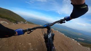
Longest blue trail in the UK. Opened in September 2021. It's a work in progress and will be a while before it's bedded in and all the bends have been built up appropriately. Currently very loose in the top third, with some rather flat bends. Faster riders will manage air; beginners should watch their speed. A couple of picnic bench stops along the way, and plenty of room to move out of the ay of faster riders. Two thirds of the trail is on exposed hillside, with the bottom third in the trees. Pops out on to the forest road at the top of Blue Steel.

Access Info

From the top of the gondola, ride up right on the dirt road that goes behind the downhill start shed. Follow this road down to the start of the trail, just before the ski lift. At the end of Blue Doon you'll pop out onto the forest road at the top of Blue Steel.

Bike Park

Recent Activity on Trail

Past Week
  • 3 rides
  • 24.4 km average
6 Months
  • 14 rides
  • 32.3 km avg distance
All
  • 181 rides
  • Last: Jun 30, 2026
c1c2c3c4
January
February
March
April
May
June
July
August
September
October
November
December
update trails status or condition

Blue Doon Trail Reports

statusdatedescription
May 10, 2026 @ 8:47am (Europe/London)
May 10, 2026
From the bridge down the trail is very dry and gravelly in places so ride accordingly. Trail tread is good overall and running well despite the...
Sep 3, 2025 @ 9:00am
Sep 3, 2025
18/8/25. Clear, dry surface a bit loose in places. Last few turns (temporary trail) a bit sketchy. Top end blue due to length, definitely not red...
Aug 16, 2025 @ 9:49am
Aug 16, 2025
clear although rough as hell all the way to blue steel... should be upgraded to a red imo, especially with the steepness in places
Oct 25, 2024 @ 2:03pm
Oct 25, 2024
reporter trail closed due to serious wind fallen trees
Oct 7, 2024 @ 11:47am
Oct 7, 2024
more »
Status:
on May 10, 2026
Very Dry
Avg: 3.28 (16 votes)
Your vote: 0

view (3,460)
close
3D
Trail Conditions
  • Unknown
  • Snow Groomed
  • Snow Packed
  • Snow Covered
  • Snow Cover Partial
  • Freeze/thaw Cycle
  • Icy
  • Prevalent Mud
  • Wet
  • Variable
  • Ideal
  • Dry
  • Very Dry
Trail Flow (Ridden Direction)
Trailforks scans users ridelogs to determine the most popular direction each trail is ridden. A good flowing trail network will have most trails flowing in a single direction according to their intension.
The colour categories are based on what percentage of riders are riding a trail in its intended direction.
  • > 96%
  • > 90%
  • > 80%
  • > 70%
  • > 50%
  • < 50%
  • bi-directional trail
  • no data
Trail Last Ridden
Trailforks scans ridelogs to determine the last time a trail was ridden.
  • < 2 days
  • < 1 week
  • < 2 weeks
  • < 1 month
  • < 6 months
  • > 6 months
Trail Ridden Direction
The intended direction a trail should be ridden.
  • Downhill Only
  • Downhill Primary
  • Both Directions
  • Uphill Primary
  • Uphill Only
  • One Direction
Contribute Details
Colors indicate trail is missing specified detail.
  • Description
  • Photos
  • Description & Photos
  • Videos
Trail Popularity ?
Trailforks scans ridelogs to determine which trails are ridden the most in the last 9 months. Trails are compared with nearby trails in the same city region with a possible 25 colour shades. Think of this as a heatmap, more rides = more kinetic energy = warmer colors.
  • most popular
  • popular
  • less popular
  • not popular
ATV/ORV/OHV Filter
Max Vehicle Width
inches
US Cell Coverage
Legend
cell carrier legend

Radar Time
Activity Recordings
Trailforks uses anonymized public activity data. ?
Activity Recordings
Trailforks uses anonymized public activity data. ?
Personal Heatmap
Activity Types
all / none
Options
2
Date range month
Winter Trails
Warning A routing network for winter maps does not exist. Selecting trails using the winter trails layer has been disabled.
Missing Trails
Most Popular
Least Popular
Trails are colored based on popularity. The more popular a trail is, the more red. Less popular trails trend towards green.
Jump Magnitude Heatmap
Heatmap of where riders jump on trails. Zoom in to see individual jumps, click circles to view jump details.
BC Backroad Status

Service Road Atlas is a free to use, community-driven service for viewing and creating reports on the numerous back-country service roads around B.C. and Alberta.

map legend
Slope Aspect
Direction the slope faces
Flat N NE E SE S SW W NW
Trails Deemphasized
Trails are shown in grey.
disable
Only show trails with no bike usage.
Enable
Suggested Layers
Based on selected activity type

    Save the current map location and zoom level as your default home location whenever this page is loaded.

    Save
        Directions to blue-doon trailhead (56.835130, -4.977300)

        Photos

        4 more »
        168 |
        Jul 30, 2022 @ 1:28pm
        Jul 30, 2022
        296 |
        Oct 31, 2021 @ 8:09am
        Oct 31, 2021
        237 |
        Oct 31, 2021 @ 8:09am
        Oct 31, 2021
        254 |
        Sep 18, 2021 @ 2:54pm
        Sep 18, 2021

        Videos

        3 more »
        Nevis Range 'Blue Doon' Mountain Bike Trail....
        15:29 | 339 | Oct 4, 2024 , Nevis Range
        Fort William (Nevis Range) - Blue Doon
        18:19 | 441 | Aug 11, 2022 , Nevis Range
        youtuber Blue Doon Fort William | The longest Blue...
        16:26 | 487 | Oct 13, 2021 , Nevis Range

        10 Reviews & Comments


        We hope you've been enjoying Trailforks!

        Create a FREE account to view trail comments and much more.

        • By gav-sTF Pro & contributors
        • #461955 - 6,536 views

        Frequently Asked Questions About Blue Doon

        Where is Blue Doon located?
        Blue Doon is located in Nevis Range Trails, Nevis Range, United Kingdom. It is part of the Nevis Range Trails trail network. The trailhead is located at coordinates 56.83513, -4.9773.
        How hard is Blue Doon?
        Blue Doon is rated as Blue difficulty. The physical rating is Moderate. The average grade is 8.2%. The climb difficulty is rated Blue.
        What is the elevation gain for Blue Doon?
        Blue Doon has 34 ft of elevation gain. The trail has 1,462 ft of elevation descent. The elevation ranges from 680 ft to 2,110 ft.
        How long is Blue Doon?
        Blue Doon is 3.3 miles long. The trail type is singletrack.

        Hit the Trail

        Open in App

        Get this trail on your phone instantly.
        open trail in app

        Download Trail

        Save to wishlist, Garmin & download.
        save the trail

        Find Related Routes

        Find routes and users activities that include this trail.
        find routes for this trail

        You must enter a description before submitting.