more stats
2,165 ft
Distance
3 ft
Climb
-382 ft
Descent
00:04:02
Avg time
-379 ft
Altitude change
828 ft
Altitude min
1,207 ft
Altitude max
1,207 ft
Altitude start
830 ft
Altitude end
-17.5%
Grade
-53.8%
Grade max
3%
Grade min
52 ft
Distance climb
2,060 ft
Distance down
52 ft
Distance flat
00:04:02
Avg time

Bock & Roll Details

  • Activities
    • Mountain Bike
    • E-Bike
  • Riding Area
  • Difficulty Rating
  • Voted Difficulty
    Red (3 votes)
  • Local Popularity
    65 in Mountain Biking [+]
    • 65 in E-Biking
  • Global Ranking
    #8153 in Mountain Biking [+]
    • #479 in E-Biking
  • Trail Type
    Singletrack
  • Bike Type
    DH, AM, XC
  • Direction
    Downhill Only
    Popular Direction Shown
  • Dogs Allowed
    Yes
  • eBike Allowed
    Yes up to Class 1
  • Year Opened
    2023

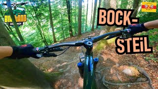
Start: Bocksberg, oberer Umsetzer Weg

Rock'n Roll ist am Bocksberg angesagt. Teil 1 ist leicht und auch für Beginner zu meistern. Ab Abschnitt 2 und später im dritten Teil wird es steil, und steiler. Bremskontrolle, Mut und Linienwahl entscheiden.

Trail Supporters
Local Trail Association

Recent Activity on Trail

Past Week
  • 0 rides
  •  
6 Months
  • 24 rides
  • 28.3 km avg distance
All
  • 100 rides
  • Last: Jun 28, 2026
c1c2c3c4
January
February
March
April
May
June
July
August
September
October
November
December
update trails status or condition

Bock & Roll Trail Reports

Status:
on Jun 1, 2026
Ideal
Avg: 4.49 (12 votes)
Your vote: 0

view (601)
close
3D
Trail Conditions
  • Unknown
  • Snow Groomed
  • Snow Packed
  • Snow Covered
  • Snow Cover Partial
  • Freeze/thaw Cycle
  • Icy
  • Prevalent Mud
  • Wet
  • Variable
  • Ideal
  • Dry
  • Very Dry
Trail Flow (Ridden Direction)
Trailforks scans users ridelogs to determine the most popular direction each trail is ridden. A good flowing trail network will have most trails flowing in a single direction according to their intension.
The colour categories are based on what percentage of riders are riding a trail in its intended direction.
  • > 96%
  • > 90%
  • > 80%
  • > 70%
  • > 50%
  • < 50%
  • bi-directional trail
  • no data
Trail Last Ridden
Trailforks scans ridelogs to determine the last time a trail was ridden.
  • < 2 days
  • < 1 week
  • < 2 weeks
  • < 1 month
  • < 6 months
  • > 6 months
Trail Ridden Direction
The intended direction a trail should be ridden.
  • Downhill Only
  • Downhill Primary
  • Both Directions
  • Uphill Primary
  • Uphill Only
  • One Direction
Contribute Details
Colors indicate trail is missing specified detail.
  • Description
  • Photos
  • Description & Photos
  • Videos
Trail Popularity ?
Trailforks scans ridelogs to determine which trails are ridden the most in the last 9 months. Trails are compared with nearby trails in the same city region with a possible 25 colour shades. Think of this as a heatmap, more rides = more kinetic energy = warmer colors.
  • most popular
  • popular
  • less popular
  • not popular
ATV/ORV/OHV Filter
Max Vehicle Width
inches
US Cell Coverage
Legend
cell carrier legend

Radar Time
Activity Recordings
Trailforks uses anonymized public activity data. ?
Activity Recordings
Trailforks uses anonymized public activity data. ?
Personal Heatmap
Activity Types
all / none
Options
2
Date range month
Winter Trails
Warning A routing network for winter maps does not exist. Selecting trails using the winter trails layer has been disabled.
Missing Trails
Most Popular
Least Popular
Trails are colored based on popularity. The more popular a trail is, the more red. Less popular trails trend towards green.
Jump Magnitude Heatmap
Heatmap of where riders jump on trails. Zoom in to see individual jumps, click circles to view jump details.
BC Backroad Status

Service Road Atlas is a free to use, community-driven service for viewing and creating reports on the numerous back-country service roads around B.C. and Alberta.

map legend
Slope Aspect
Direction the slope faces
Flat N NE E SE S SW W NW
Trails Deemphasized
Trails are shown in grey.
disable
Only show trails with no bike usage.
Enable
Suggested Layers
Based on selected activity type

    Save the current map location and zoom level as your default home location whenever this page is loaded.

    Save
        Directions to bock--roll trailhead (49.455110, 8.967820)

        Photos

        5 more »
        17 |
        May 1, 2026 @ 4:57am
        May 1, 2026
        32 |
        Jun 15, 2025 @ 11:33pm
        Jun 15, 2025
        24 |
        Jun 15, 2025 @ 11:33pm
        Jun 15, 2025
        66 |
        May 25, 2023 @ 3:39pm
        May 25, 2023

        Videos

        6 more »
        youtuber BIKELÄND EBERBACH Steiäl is geiäl: Bock n...
        6:47 | 96 | Jun 6, 2025 , Eberbach
        youtuber FOX DROPFRAME Pro: Jay Checks Stuff /...
        8:34 | 166 | May 10, 2024 , Eberbach
        EMTB - Bikeländ Eberbach - schwer, schwerer,...
        15:06 | 56 | Nov 5, 2024 , Eberbach
        youtuber Bok abd Roll - Bikeländ Eberbach // Winter...
        4:30 | 177 | Jan 11, 2024 , Eberbach

        Routes with this trail

        4.3 27 miles 6,262 ft 25
        Die Rundstrecke mit allen 12 Trails im BIKELÄND. Sie ist mit dem Logo "Eb3" beschildert. Gestartet wird...

        4 Reviews & Comments


        We hope you've been enjoying Trailforks!

        Create a FREE account to view trail comments and much more.

        • By Freischneider & contributors
        • #644473 - 1,008 views

        Frequently Asked Questions About Bock & Roll

        Where is Bock & Roll located?
        Bock & Roll is located in Bikeländ Eberbach, Eberbach, Germany. It is part of the Bikeländ Eberbach trail network. The trailhead is located at coordinates 49.45511, 8.96782.
        How hard is Bock & Roll?
        Bock & Roll is rated as Black difficulty. The average grade is 17.5%.
        What is the elevation gain for Bock & Roll?
        Bock & Roll has 3 ft of elevation gain. The trail has 382 ft of elevation descent. The elevation ranges from 828 ft to 1,207 ft.
        Is Bock & Roll a point to point trail?
        Yes, Bock & Roll is a point to point trail. The direction is Downhill Only. The trail type is singletrack.

        Hit the Trail

        Open in App

        Get this trail on your phone instantly.
        open trail in app

        Download Trail

        Save to wishlist, Garmin & download.
        save the trail

        Find Related Routes

        Find routes and users activities that include this trail.
        find routes for this trail

        You must enter a description before submitting.