more stats
1.4 miles
Distance
29 ft
Climb
-845 ft
Descent
00:26:48
Avg time
-816 ft
Altitude change
843 ft
Altitude min
1,659 ft
Altitude max
1,659 ft
Altitude start
843 ft
Altitude end
-11.3%
Grade
-46.5%
Grade max
13.7%
Grade min
476 ft
Distance climb
1 mile
Distance down
650 ft
Distance flat
00:26:48
Avg time

Boneshaker Details

  • Activities
    • Mountain Bike
    • E-Bike
  • Riding Area
    Velo MSM
    Lac-Sainte-Marie, Quebec
  • Difficulty Rating
  • Voted Difficulty
    Double Black Diamond (1 vote)
  • Local Popularity
    85 in Mountain Biking [+]
    • 90 in E-Biking
  • Global Ranking
    #5374 in Mountain Biking [+]
    • #33165 in E-Biking
  • Trail Type
    Singletrack
  • Bike Type
    AM
  • Direction
    Downhill Only
    Popular Direction Shown
  • Trail Visibility
    Always easy to follow
  • Dogs Allowed
    Yes
  • eBike Allowed
    Yes up to Class 1
  • TTFs on Trail
    Drop, Jump, Gap Jump, Rock Face
  • Land Owner
    Velo MSM

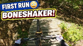
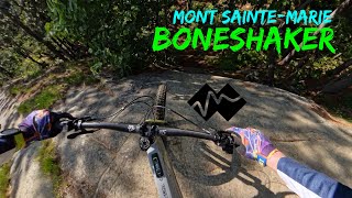
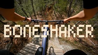
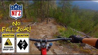
Technical singletrack with narrow traverses and steep descents, often involving rock faces.

Access Info

Ride up TTOP to the Gazebo, from the Gazebo about 20m to the right is the entrance to Stout, follow stout, and then merge left onto imperial stout, to join back with Radar road. Continue up Radar Road to the next intersection, take a left onto the Cheval Connector which will bring you up a steep climb to the top of a chairlift. Boneshaker is just beyond the chairlift up and to the left.

Local Trail Association

Recent Activity on Trail

Past Week
  • 0 rides
  •  
6 Months
  • 39 rides
  • 25 miles avg distance
All
  • 489 rides
  • Last: Jun 29, 2026
c1c2c3c4
January
February
March
April
May
June
July
August
September
October
November
December
update trails status or condition

Boneshaker Trail Reports

Status:
on Jun 14, 2026
Ideal
Avg: 4.65 (42 votes)
Your vote: 0

view (3,044)
close
3D
Trail Conditions
  • Unknown
  • Snow Groomed
  • Snow Packed
  • Snow Covered
  • Snow Cover Partial
  • Freeze/thaw Cycle
  • Icy
  • Prevalent Mud
  • Wet
  • Variable
  • Ideal
  • Dry
  • Very Dry
Trail Flow (Ridden Direction)
Trailforks scans users ridelogs to determine the most popular direction each trail is ridden. A good flowing trail network will have most trails flowing in a single direction according to their intension.
The colour categories are based on what percentage of riders are riding a trail in its intended direction.
  • > 96%
  • > 90%
  • > 80%
  • > 70%
  • > 50%
  • < 50%
  • bi-directional trail
  • no data
Trail Last Ridden
Trailforks scans ridelogs to determine the last time a trail was ridden.
  • < 2 days
  • < 1 week
  • < 2 weeks
  • < 1 month
  • < 6 months
  • > 6 months
Trail Ridden Direction
The intended direction a trail should be ridden.
  • Downhill Only
  • Downhill Primary
  • Both Directions
  • Uphill Primary
  • Uphill Only
  • One Direction
Contribute Details
Colors indicate trail is missing specified detail.
  • Description
  • Photos
  • Description & Photos
  • Videos
Trail Popularity ?
Trailforks scans ridelogs to determine which trails are ridden the most in the last 9 months. Trails are compared with nearby trails in the same city region with a possible 25 colour shades. Think of this as a heatmap, more rides = more kinetic energy = warmer colors.
  • most popular
  • popular
  • less popular
  • not popular
ATV/ORV/OHV Filter
Max Vehicle Width
inches
US Cell Coverage
Legend
cell carrier legend

Radar Time
Activity Recordings
Trailforks uses anonymized public activity data. ?
Activity Recordings
Trailforks uses anonymized public activity data. ?
Personal Heatmap
Activity Types
all / none
Options
2
Date range month
Winter Trails
Warning A routing network for winter maps does not exist. Selecting trails using the winter trails layer has been disabled.
Missing Trails
Most Popular
Least Popular
Trails are colored based on popularity. The more popular a trail is, the more red. Less popular trails trend towards green.
Jump Magnitude Heatmap
Heatmap of where riders jump on trails. Zoom in to see individual jumps, click circles to view jump details.
BC Backroad Status

Service Road Atlas is a free to use, community-driven service for viewing and creating reports on the numerous back-country service roads around B.C. and Alberta.

map legend
Slope Aspect
Direction the slope faces
Flat N NE E SE S SW W NW
Trails Deemphasized
Trails are shown in grey.
disable
Only show trails with no bike usage.
Enable
Suggested Layers
Based on selected activity type

    Save the current map location and zoom level as your default home location whenever this page is loaded.

    Save
        Directions to boneshaker trailhead (45.939290, -75.857480)

        Photos

        54 more »
        88 |
        Sep 22, 2025 @ 9:29pm
        Sep 22, 2025
        88 |
        Sep 6, 2024 @ 1:09pm
        Sep 6, 2024
        85 |
        Sep 6, 2024 @ 1:09pm
        Sep 6, 2024
        277 |
        Oct 2, 2022 @ 8:15pm
        Oct 2, 2022

        Videos

        16 more »
        First Time Riding BONESHAKER at Velo MSM
        4:02 | 44 | Jan 5, 2026 , Lac-Sainte-Marie
        Boneshaker - Mont Sainte-Marie
        9:31 | 144 | Jul 3, 2025 , Lac-Sainte-Marie
        Boneshaker - Mont-Ste-Marie, QC
        7:27 | 344 | Sep 13, 2024 , Lac-Sainte-Marie
        youtuber Most INSANE Moments of 2023! (Pt. 3) - 'The Meat'
        22:04 | 205 | Dec 24, 2023 , Lac-Sainte-Marie

        13 Reviews & Comments


        We hope you've been enjoying Trailforks!

        Create a FREE account to view trail comments and much more.

        • By TylerDCATF Pro VMSM & contributors
        • #40301 - 7,890 views

        Frequently Asked Questions About Boneshaker

        Where is Boneshaker located?
        Boneshaker is located in Velo MSM, Lac-Sainte-Marie, Quebec, Canada. It is part of the Velo MSM trail network. The trailhead is located at coordinates 45.93929, -75.85748.
        How hard is Boneshaker?
        Boneshaker is rated as Double Black Diamond difficulty. The average grade is 11.3%.
        What is the elevation gain for Boneshaker?
        Boneshaker has 29 ft of elevation gain. The trail has 845 ft of elevation descent. The elevation ranges from 843 ft to 1,659 ft.
        Is Boneshaker a point to point trail?
        Yes, Boneshaker is a point to point trail. The direction is Downhill Only. The trail type is singletrack.

        Hit the Trail

        Open in App

        Get this trail on your phone instantly.
        open trail in app

        Download Trail

        Save to wishlist, Garmin & download.
        save the trail

        Find Related Routes

        Find routes and users activities that include this trail.
        find routes for this trail

        You must enter a description before submitting.