more stats
423 ft
Distance
-32 ft
Descent
1,783 ft
High Point
-32 ft
Altitude change
1,751 ft
Altitude min
1,783 ft
Altitude start
1,752 ft
Altitude end
-7.6%
Grade
-18.6%
Grade max
-0.7%
Grade min
16 ft
Distance climb
305 ft
Distance down
105 ft
Distance flat

Breakerfall Details

  • Activities
    • Mountain Bike
  • Riding Area
    Quesnel Bike Park
    Quesnel, British Columbia
  • Difficulty Rating
  • Local Popularity
    95 in Mountain Biking
  • Global Ranking
    #7000 in Mountain Biking
  • Trail Type
    Singletrack
  • Direction
    Downhill Only
    Popular Direction Shown
  • eBike Allowed
  • TTFs on Trail
    Drop, Ladder Bridge, Log Ride, Rock Face, Rock Garden, Skinny
  • Land Owner
    City of Quesnel

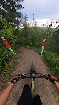
Take the skinny challenge to the next level A woodworking master piece, will challenge the most advanced riders to clean this line. Not for the faint of heart but worthy of a challenge or at least a look!

Practice in the balance park of the skills park then proceed to claim the title of skinny master.

Mandatory rock garden to drop to start your adventure.

Pre-ride, Re-ride, FREERIDE

Local Trail Association

Recent Activity on Trail

Past Week
  • 2 rides
  • 6 miles average
6 Months
  • 5 rides
  • 8 miles avg distance
All
  • 32 rides
  • Last: Jun 28, 2026
c1c2c3c4
January
February
March
April
May
June
July
August
September
October
November
December
update trails status or condition

Breakerfall Trail Reports

statusdatedescription
Apr 13, 2026 @ 6:44pm (America/Vancouver)
Apr 13, 2026
reporter Open - Early Season Conditions
Mar 23, 2026 @ 9:23am (America/Vancouver)
Mar 23, 2026
reporter Closed during spring melt - Please respect the closure until the Bike Park dries out
Jun 18, 2025 @ 12:15pm
Jun 18, 2025
Apr 7, 2025 @ 8:07pm
Apr 7, 2025
reporter Early Season conditions - ride with caution
Apr 6, 2025 @ 11:44am
Apr 6, 2025
reporter Open early season conditions
more »
Status:
on Apr 13, 2026
Ideal
Avg: 4.13 (1 votes)
Your vote: 0

view (338)
close
3D
Trail Conditions
  • Unknown
  • Snow Groomed
  • Snow Packed
  • Snow Covered
  • Snow Cover Partial
  • Freeze/thaw Cycle
  • Icy
  • Prevalent Mud
  • Wet
  • Variable
  • Ideal
  • Dry
  • Very Dry
Trail Flow (Ridden Direction)
Trailforks scans users ridelogs to determine the most popular direction each trail is ridden. A good flowing trail network will have most trails flowing in a single direction according to their intension.
The colour categories are based on what percentage of riders are riding a trail in its intended direction.
  • > 96%
  • > 90%
  • > 80%
  • > 70%
  • > 50%
  • < 50%
  • bi-directional trail
  • no data
Trail Last Ridden
Trailforks scans ridelogs to determine the last time a trail was ridden.
  • < 2 days
  • < 1 week
  • < 2 weeks
  • < 1 month
  • < 6 months
  • > 6 months
Trail Ridden Direction
The intended direction a trail should be ridden.
  • Downhill Only
  • Downhill Primary
  • Both Directions
  • Uphill Primary
  • Uphill Only
  • One Direction
Contribute Details
Colors indicate trail is missing specified detail.
  • Description
  • Photos
  • Description & Photos
  • Videos
Trail Popularity ?
Trailforks scans ridelogs to determine which trails are ridden the most in the last 9 months. Trails are compared with nearby trails in the same city region with a possible 25 colour shades. Think of this as a heatmap, more rides = more kinetic energy = warmer colors.
  • most popular
  • popular
  • less popular
  • not popular
ATV/ORV/OHV Filter
Max Vehicle Width
inches
US Cell Coverage
Legend
cell carrier legend

Radar Time
Activity Recordings
Trailforks uses anonymized public activity data. ?
Activity Recordings
Trailforks uses anonymized public activity data. ?
Personal Heatmap
Activity Types
all / none
Options
2
Date range month
Winter Trails
Warning A routing network for winter maps does not exist. Selecting trails using the winter trails layer has been disabled.
Missing Trails
Most Popular
Least Popular
Trails are colored based on popularity. The more popular a trail is, the more red. Less popular trails trend towards green.
Jump Magnitude Heatmap
Heatmap of where riders jump on trails. Zoom in to see individual jumps, click circles to view jump details.
BC Backroad Status

Service Road Atlas is a free to use, community-driven service for viewing and creating reports on the numerous back-country service roads around B.C. and Alberta.

map legend
Slope Aspect
Direction the slope faces
Flat N NE E SE S SW W NW
Trails Deemphasized
Trails are shown in grey.
disable
Only show trails with no bike usage.
Enable
Suggested Layers
Based on selected activity type

    Save the current map location and zoom level as your default home location whenever this page is loaded.

    Save
        Directions to breakerfall trailhead (52.984460, -122.463460)

        Photos

        No photos have been added for Breakerfall yet, add a photo.

        Videos

        2 more »
        Drop in the dark
        0:17 | 28 | Jun 30, 2025 , Quesnel
        Best drop
        0:15 | 87 | Jul 25, 2024 , Quesnel

        Routes with this trail

        2 miles 205 ft 6 Race
        2025 Lhtako Dene Mountain Bike Festival - Downhill Stage 1. Around the Bend Stage 2. Even Flow

        1 Review & Comments


        We hope you've been enjoying Trailforks!

        Create a FREE account to view trail comments and much more.

        • By ivlTF Pro GRCC & contributors
        • #776095 - 296 views

        Frequently Asked Questions About Breakerfall

        Where is Breakerfall located?
        Breakerfall is located in Quesnel Bike Park, Quesnel, British Columbia, Canada. It is part of the Quesnel Bike Park trail network. The trailhead is located at coordinates 52.98446, -122.46346.
        How hard is Breakerfall?
        Breakerfall is rated as Black Diamond difficulty. The average grade is 7.6%.
        What is the elevation gain for Breakerfall?
        The trail has 10 m of elevation descent. The elevation ranges from 534 m to 544 m.
        Is Breakerfall a point to point trail?
        Yes, Breakerfall is a point to point trail. The direction is Downhill Only. The trail type is singletrack.

        Hit the Trail

        Open in App

        Get this trail on your phone instantly.
        open trail in app

        Download Trail

        Save to wishlist, Garmin & download.
        save the trail

        Find Related Routes

        Find routes and users activities that include this trail.
        find routes for this trail

        You must enter a description before submitting.