more stats
141 ft
Distance
456 ft
High Point
-2 ft
Altitude change
454 ft
Altitude min
456 ft
Altitude start
453 ft
Altitude end
-1.6%
Grade
-2.9%
Grade max
-0.9%
Grade min
46 ft
Distance down
95 ft
Distance flat

Brenneslestien Details

  • Activities
    • Mountain Bike
    • E-Bike
    • Winter Fat Bike
    • Hike
    • Trail Running
  • Riding Area
  • Difficulty Rating
  • Local Popularity
    5 in Mountain Biking [+]
    • 5 in E-Biking
    • 5 in Trail Running
    • 5 in Hiking
  • Global Ranking
    #29912 in Mountain Biking
  • Hiking SAC Scale
    T1 Hiking
  • Trail Type
    Singletrack
  • Bike Type
    AM, XC, Fat
  • Climb Difficulty
    Blue
  • Physical Rating
    Easy
  • Trail Visibility
    Sometimes hard to follow
  • Season
    spring, autumn,winter
  • Dogs Allowed
    Yes
  • eBike Allowed
    Yes up to Class 1

Norsk
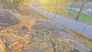
Stien starter lett med grass område, som kan bli overgrodd til tider om sommeren.
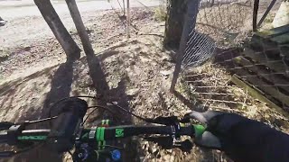
Bunnen av stien går nær gjerdet og nær et tree, og slutter med en bakke ned til sykkelveien.
Om sommeren kan stien være helt overgrodd.
Om sommeren kan stien være fullstendig gjengrodd. Kommunen ser ut til å bare klippe den om våren, og aldri om sommeren.

English
The trail trail starts easy with a grass area, which can get overgrown in the summer.
The bottom of the trail goes to the fence and goes close to a tree and the fence, ends with a slope to the bike path.
In the summer the trail can be completely overgrown. The municipality seems to only cut it in the spring, and never in the summer.

Local Trail Association

Recent Activity on Trail

Past Week
  • 0 rides
  •  
6 Months
  • 0 rides
  •  
All
  • 50 rides
  • Last: Apr 1, 2023
update trails status or condition

Brenneslestien Trail Reports

statusdatedescription
Oct 15, 2025 @ 5:41am (Europe/Oslo)
Oct 14, 2025
reporter forsatt helt tilgrodd still completely overgrown
Jul 24, 2025 @ 1:04pm
Jul 24, 2025
Komplett gjengrodd, fra toppen er den helt usynlig. Fullt av massive brennenesler. Completely overgrown vegetation, invisible from the top....
Aug 18, 2024 @ 2:47pm
Aug 18, 2024
reporter For overgrodd. Too overgrown.
Apr 14, 2022 @ 4:16am
Apr 14, 2022
great condition, the weeds have been cut, great visibility. god stand, ugresset er kuttet, god synlighet.
Nov 7, 2020 @ 1:32am
Nov 7, 2020
reporter
more »
Status:
on Oct 15, 2025
Ideal
Avg: 4.13 (1 votes)
Your vote: 0

view (58)
close
3D
Trail Conditions
  • Unknown
  • Snow Groomed
  • Snow Packed
  • Snow Covered
  • Snow Cover Partial
  • Freeze/thaw Cycle
  • Icy
  • Prevalent Mud
  • Wet
  • Variable
  • Ideal
  • Dry
  • Very Dry
Trail Flow (Ridden Direction)
Trailforks scans users ridelogs to determine the most popular direction each trail is ridden. A good flowing trail network will have most trails flowing in a single direction according to their intension.
The colour categories are based on what percentage of riders are riding a trail in its intended direction.
  • > 96%
  • > 90%
  • > 80%
  • > 70%
  • > 50%
  • < 50%
  • bi-directional trail
  • no data
Trail Last Ridden
Trailforks scans ridelogs to determine the last time a trail was ridden.
  • < 2 days
  • < 1 week
  • < 2 weeks
  • < 1 month
  • < 6 months
  • > 6 months
Trail Ridden Direction
The intended direction a trail should be ridden.
  • Downhill Only
  • Downhill Primary
  • Both Directions
  • Uphill Primary
  • Uphill Only
  • One Direction
Contribute Details
Colors indicate trail is missing specified detail.
  • Description
  • Photos
  • Description & Photos
  • Videos
Trail Popularity ?
Trailforks scans ridelogs to determine which trails are ridden the most in the last 9 months. Trails are compared with nearby trails in the same city region with a possible 25 colour shades. Think of this as a heatmap, more rides = more kinetic energy = warmer colors.
  • most popular
  • popular
  • less popular
  • not popular
ATV/ORV/OHV Filter
Max Vehicle Width
inches
US Cell Coverage
Legend
cell carrier legend

Radar Time
Activity Recordings
Trailforks uses anonymized public activity data. ?
Activity Recordings
Trailforks uses anonymized public activity data. ?
Personal Heatmap
Activity Types
all / none
Options
2
Date range month
Winter Trails
Warning A routing network for winter maps does not exist. Selecting trails using the winter trails layer has been disabled.
Missing Trails
Most Popular
Least Popular
Trails are colored based on popularity. The more popular a trail is, the more red. Less popular trails trend towards green.
Jump Magnitude Heatmap
Heatmap of where riders jump on trails. Zoom in to see individual jumps, click circles to view jump details.
BC Backroad Status

Service Road Atlas is a free to use, community-driven service for viewing and creating reports on the numerous back-country service roads around B.C. and Alberta.

map legend
Slope Aspect
Direction the slope faces
Flat N NE E SE S SW W NW
Trails Deemphasized
Trails are shown in grey.
disable
Only show trails with no bike usage.
Enable
Suggested Layers
Based on selected activity type

    Save the current map location and zoom level as your default home location whenever this page is loaded.

    Save
        Directions to brenneslestien trailhead (59.585310, 11.156120)

        Photos

        No photos have been added for Brenneslestien yet, add a photo.

        Videos

        5 more »
        youtuber 14.11.2020 Askimbyen Skole part 1
        2:07 | 198 | Nov 7, 2020 , Askim
        youtuber 14 May 2019 technical riding at Askimbyen skole
        0:31 | 205 | May 30, 2019 , Askim
        youtuber 1 March 2019 good time to ride this trail
        0:48 | 239 | Mar 8, 2019 , Askim
        youtuber 22 May 2019 Ride up and down a stairs trail -
        2:12 | 197 | May 28, 2019 , Askim

        Reviews / Comments

        No reviews yet, be the first to write a review or ask a question.
        Use trail reports to comment on trail conditions.


        We hope you've been enjoying Trailforks!

        Create a FREE account to view trail comments and much more.

        Frequently Asked Questions About Brenneslestien

        Where is Brenneslestien located?
        Brenneslestien is located in Askim, Norway. It is part of the Askim trail network. The trailhead is located at coordinates 59.58531, 11.15612.
        How hard is Brenneslestien?
        Brenneslestien is rated as Blue difficulty. The physical rating is Easy. The average grade is 1.6%. The climb difficulty is rated Blue.
        How long is Brenneslestien?
        Brenneslestien is 43.0 m long. The trail type is singletrack.
        Are dogs allowed on Brenneslestien?
        Yes, dogs are allowed on Brenneslestien. Please keep dogs on a leash where required and clean up after them.

        Hit the Trail

        Open in App

        Get this trail on your phone instantly.
        open trail in app

        Download Trail

        Save to wishlist, Garmin & download.
        save the trail

        Find Related Routes

        Find routes and users activities that include this trail.
        find routes for this trail

        You must enter a description before submitting.