3.8 miles
Distance
385 ft
Climb
-388 ft
Descent
00:36:41
Avg time
Brown Mill Details
-
Activities
- Mountain Bike
- Hike
- Trail Running
-
Riding AreaBrown Mill Mountain Bike Trail
Concord, North Carolina -
Difficulty Rating
-
Trail TypeSingletrack
-
Bike TypeAM, XC
-
DirectionOne Direction
-
Climb DifficultyBlue
-
Physical RatingModerate
-
Dogs AllowedYes
-
TTFs on TrailBerm, Drop, Jump, Rock Face
-
Global Ranking
-
Local Popularity100 in Mountain Biking [+]
- 5 in Trail Running
- 100 in Hiking
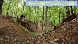
Short but sweet 4.6-mile trail in Concord. Has some decent climbs, flowy sections, and rock features as well. Please be respectful when parking as there is a private home across from the trailhead. Brown Mill is an excellent trail to lap time after time and is suitable for most riders with avoidable features. Check trail status at https://tarheeltrailblazers.com/trails/brownmill/
Access Info
Parking located at:
7 2nd St SW, Concord, NC 28027
Local Trail Association
-
Please consider joining or donating to the local trail association to supportdonate to earn trail karma!
trail development & maintenance.
More Stats for Brown Mill multi-use trail trail
-
Altitude change0 ft
-
Altitude min651 ft
-
Altitude max730 ft
-
Altitude start712 ft
-
Altitude end712 ft
-
Grade max-17.9%
-
Grade min19.1%
-
Distance climb1 mile
-
Distance down1 mile
-
Distance flat4,508 ft
-
Avg time00:36:41
-
Avg reverse time00:37:56
- view trail stats
close
3D
Trail Conditions
- Unknown
- Snow Groomed
- Snow Packed
- Snow Covered
- Snow Cover Partial
- Freeze/thaw Cycle
- Icy
- Prevalent Mud
- Wet
- Variable
- Ideal
- Dry
- Very Dry
Trail Flow (Ridden Direction)
Trailforks scans users ridelogs to determine the most popular direction each trail is ridden. A good flowing trail network will have most trails flowing in a single direction according to their intension.
The colour categories are based on what percentage of riders are riding a trail in its intended direction.
- > 96%
- > 90%
- > 80%
- > 70%
- > 50%
- < 50%
- bi-directional trail
- no data
Trail Last Ridden
Trailforks scans ridelogs to determine the last time a trail was ridden.
- < 2 days
- < 1 week
- < 2 weeks
- < 1 month
- < 6 months
- > 6 months
Trail Ridden Direction
The intended direction a trail should be ridden.
- Downhill Only
- Downhill Primary
- Both Directions
- Uphill Primary
- Uphill Only
- One Direction
Contribute Details
Colors indicate trail is missing specified detail.
- Description
- Photos
- Description & Photos
- Videos
Trail Popularity ?
Trailforks scans ridelogs to determine which trails are ridden the most in the last 9 months.
Trails are compared with nearby trails in the same city region with a possible 25 colour shades.
Think of this as a heatmap, more rides = more kinetic energy = warmer colors.
- most popular
- popular
- less popular
- not popular
ATV/ORV/OHV Filter
Max Vehicle Width
inches
US Cell Coverage
Legend
Radar Time
x
Activity Recordings
Trailforks users anonymized public ridelogs from the past 6 months.
- mountain biking recent
- mountain biking (>6 month)
- hiking (1 year)
- moto (1 year)
Activity Recordings
Trailforks users anonymized public skilogs from the past 12 months.
- Downhill Ski
- Backcountry Ski
- Nordic Ski
- Snowmobile
Winter Trails
Warning
A routing network for winter maps does not exist. Selecting trails using the winter trails layer has been disabled.
x
Missing Trails
Most Popular
Least Popular
Trails are colored based on popularity. The more popular a trail is, the more red. Less popular trails trend towards green.
Jump Magnitude Heatmap
Heatmap of where riders jump on trails. Zoom in to see individual jumps, click circles to view jump details.
Trails Deemphasized
Trails are shown in grey.
Only show trails with NO bikes.
Save the current map location and zoom level as your default home location whenever this page is loaded.
Save
Directions to brown-mill trailhead
(35.396200, -80.602640)
update trails status or condition
Brown Mill Trail Reports
view all reports »
Recent Ridelog Activity on Trail
Past Week
- 1 rides
- 9 miles avg distance
6 Months
- 34 rides
- 5 miles avg distance
All
- 277 rides
- Last: Apr 18, 2025
Photos
more »
We hope you've been enjoying Trailforks!
Create a FREE account to view trail comments and much more.
Nearby Trails
- Hector H. Henry Ii Greenway 10 miles
- Mallard Creek Greenway 14 miles
- Clarks Creek Greenway 17 miles
- Dragonfly Pond Connector 18 miles
- Sassafras Trail 18 miles
Brown Mill Mountain Bike Trail
- By RMSlayer50
& contributors
- #449839 - 7,490 views
- follow/subscribe
- login to download gpx or kml files.
You must enter a description before submitting.