3.3 miles
Distance
304 ft
Climb
-428 ft
Descent
00:35:57
Avg time

Brujas Details

  • Activities
    • Mountain Bike
    • E-Bike
    • Hike
    • Trail Running
  • Riding Area
  • AKA
    Brujitas, Nido del Aguila
  • Difficulty Rating
  • Voted Difficulty
    Blue (1 vote)
  • Trail Type
    Singletrack
  • Bike Type
    AM, XC
  • Direction
    Downhill Primary
    Popular direction shown
  • Climb Difficulty
    Blue
  • Physical Rating
    Moderate
  • Trail Visibility
    Always easy to follow
  • eBike Allowed
    Yes up to Class 1
  • TTFs on Trail
    Berm, Drop, Rock Garden, Skinny
  • Global Ranking
    #16893 in Mountain Biking [+]
    • #93312 in Trail Running
  • Local Popularity
    75 in Mountain Biking [+]
    • 85 in E-Biking
    • 5 in Trail Running
    • 5 in Hiking

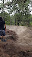
Brujas, o Brujitas, es un Trail principalmente de bajada técnica, fluída y mixta. Cuenta con curvas peraltadas y segmentos de recta que pueden ser muy rápidos.
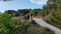
Anteriormente se le conocía sólo como "Nido de el Águila", ya que la subida terminaba en un descanso que ofrece una buena vista hacia el cerro donde se ubica la Torre 3 y así se le conoce. La sección de bajada empieza justo en ése punto y termina al inicio de la subida a Torre 3 por el camino conocido como "Corniza" o "Via Corta". El final tiene su cereza con un drop de buena altura y un recibidor trabajado con adopasto.
Si tienes intenciones de rodarla, debes tener en cuenta a qué distancia estás de la entrada y ahorrar energía para el regreso.


Brujas, or Brujitas, is a mainly technical, fluid and mixed descent. It has banked curves and straight segments that can be very fast.
Previously it was known as "Nido del Aguila", since the climb ended in a rest that offers a good view of the hill where Tower 3 is located and that is how it is known. The downhill section begins right at that point and ends at the beginning of the climb to Torre 3 along the path known as "Corniza" or "Via Corta". The finale has its cherry with a good height drop and a receiver worked with adopasto.
If you ride it, you have to be aware how far you are from the entrance and save energy to retun

Access Info

A la izquierda al final de la cerca en el camino a Obsidianas, después de pasar el final de Toboganes

Traditionally Indigenous Territory
More Stats for Brujas mountain bike trail trail
  • Altitude change
    -124 ft
  • Altitude min
    5,894 ft
  • Altitude max
    6,305 ft
  • Altitude start
    6,018 ft
  • Altitude end
    5,896 ft
  • Grade
    -0.7%
  • Grade max
    -38.6%
  • Grade min
    13.6%
  • Distance climb
    2 miles
  • Distance down
    1 mile
  • Distance flat
    2,080 ft
  • Avg time
    00:35:57
  • Avg reverse time
    00:31:55
  • view trail stats
Status:
on Jul 3, 2025
Ideal
Avg: 3.99 (2 votes)
Your vote: 0

view (614)
close
3D
Trail Conditions
  • Unknown
  • Snow Groomed
  • Snow Packed
  • Snow Covered
  • Snow Cover Partial
  • Freeze/thaw Cycle
  • Icy
  • Prevalent Mud
  • Wet
  • Variable
  • Ideal
  • Dry
  • Very Dry
Trail Flow (Ridden Direction)
Trailforks scans users ridelogs to determine the most popular direction each trail is ridden. A good flowing trail network will have most trails flowing in a single direction according to their intension.
The colour categories are based on what percentage of riders are riding a trail in its intended direction.
  • > 96%
  • > 90%
  • > 80%
  • > 70%
  • > 50%
  • < 50%
  • bi-directional trail
  • no data
Trail Last Ridden
Trailforks scans ridelogs to determine the last time a trail was ridden.
  • < 2 days
  • < 1 week
  • < 2 weeks
  • < 1 month
  • < 6 months
  • > 6 months
Trail Ridden Direction
The intended direction a trail should be ridden.
  • Downhill Only
  • Downhill Primary
  • Both Directions
  • Uphill Primary
  • Uphill Only
  • One Direction
Contribute Details
Colors indicate trail is missing specified detail.
  • Description
  • Photos
  • Description & Photos
  • Videos
Trail Popularity ?
Trailforks scans ridelogs to determine which trails are ridden the most in the last 9 months. Trails are compared with nearby trails in the same city region with a possible 25 colour shades. Think of this as a heatmap, more rides = more kinetic energy = warmer colors.
  • most popular
  • popular
  • less popular
  • not popular
ATV/ORV/OHV Filter
Max Vehicle Width
inches
US Cell Coverage
Legend
cell carrier legend

Radar Time
x Activity Recordings
Trailforks users anonymized public ridelogs from the past 6 months.
  • mountain biking recent
  • mountain biking (>6 month)
  • hiking (1 year)
  • moto (1 year)
Activity Recordings
Trailforks users anonymized public skilogs from the past 12 months.
  • Downhill Ski
  • Backcountry Ski
  • Nordic Ski
  • Snowmobile
Winter Trails
Warning A routing network for winter maps does not exist. Selecting trails using the winter trails layer has been disabled.
x Missing Trails
Most Popular
Least Popular
Trails are colored based on popularity. The more popular a trail is, the more red. Less popular trails trend towards green.
Jump Magnitude Heatmap
Heatmap of where riders jump on trails. Zoom in to see individual jumps, click circles to view jump details.
Trails Deemphasized
Trails are shown in grey.
disable
Only show trails with NO bikes.
enable

Save the current map location and zoom level as your default home location whenever this page is loaded.

Save
      Directions to brujas trailhead (20.624120, -103.562290)
      update trails status or condition

      Brujas Trail Reports

      statusdatedescription
      Jul 3, 2025 @ 4:27pm
      Jul 3, 2025
      Mar 22, 2025 @ 7:50am
      Mar 22, 2025
      Mar 17, 2025 @ 8:52am
      Mar 17, 2025
      Dec 12, 2024 @ 5:42pm
      Dec 12, 2024
      Dec 10, 2024 @ 4:50pm
      Dec 10, 2024
      Limpieza general al trail. Destaparon los peraltes y quitaron un par de arboles que obstruían la pista
      view all reports »

      Recent Ridelog Activity on Trail

      Past Week
      • 0 rides
      •  
      6 Months
      • 2 rides
      • 18 miles avg distance
      All
      • 23 rides
      • Last: Jul 17, 2025

      Photos

      more »
      51 |
      Jul 13, 2020 @ 10:52am
      Jul 13, 2020
      6 |
      Dec 10, 2024 @ 4:56pm
      Dec 10, 2024
      6 |
      Dec 10, 2024 @ 4:56pm
      Dec 10, 2024
      6 |
      Dec 10, 2024 @ 4:56pm
      Dec 10, 2024

      Routes with this trail

      titledistance
      La Primavera Periferia.46 miles
      Volcanes/Torre312 miles

      Reviews / Comments

      No reviews yet, be the first to write a review or ask a question.
      Use trail reports to comment on trail conditions.


      We hope you've been enjoying Trailforks!

      Create a FREE account to view trail comments and much more.

      Videos

      more »
      0:07 | 7 | Jan 10, 2025 , Zapopan
      0:48 | 2 | Jan 10, 2025 , Zapopan
      • By elcaribou & contributors
      • #117246 - 1,560 views

      You must enter a description before submitting.