more stats
1.6 miles
Distance
80 ft
Climb
-531 ft
Descent
00:10:58
Avg time
-450 ft
Altitude change
1,374 ft
Altitude min
1,849 ft
Altitude max
1,849 ft
Altitude start
1,398 ft
Altitude end
-5.2%
Grade
-52.1%
Grade max
16.5%
Grade min
2,129 ft
Distance climb
1 mile
Distance down
276 ft
Distance flat
00:10:58
Avg time

Buck Details

  • Activities
    • Mountain Bike
    • E-Bike
    • Hike
    • Trail Running
  • Riding Area
    Carvin's Cove
    Roanoke, Virginia
  • Difficulty Rating
  • Voted Difficulty
    Black Diamond (3 votes)
  • Local Popularity
    65 in Mountain Biking [+]
    • 85 in E-Biking
    • 50 in Trail Running
    • 60 in Hiking
  • Global Ranking
    #10459 in Mountain Biking [+]
    • #26491 in E-Biking
    • #72411 in Hiking
  • Trail Type
    Singletrack
  • Bike Type
    AM, XC
  • Direction
    Both Directions[+]
    Popular Direction Shown
    • Both Directions for E-Biking
    • Both Directions for Trail Running
    • Both Directions for Hiking
  • Dogs Allowed
    Yes
  • eBike Allowed
    Yes up to Class 1
  • Land Owner
    Roanoke City

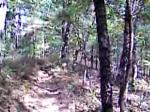
Buck can be ridden in either direction and offers either a challenging climb up to Brushy Mountain Fire Road, with some tight switchbacks and steep root moves, or a ripping descent coming down.

Local Trail Association
Traditionally Indigenous Territory

Recent Activity on Trail

Past Week
  • 1 rides
  • 17.1 km average
6 Months
  • 21 rides
  • 22.9 km avg distance
All
  • 188 rides
  • Last: Jun 5, 2026
c1c2c3c4
January
February
March
April
May
June
July
August
September
October
November
December
update trails status or condition

Buck Trail Reports

statusdatedescription
Apr 6, 2026 @ 5:30pm (America/Kentucky/Monticello)
Apr 6, 2026
reporter
Mar 3, 2026 @ 5:25pm (America/New_York)
Mar 3, 2026
reporter Trail surface is mostly solid, with just a few remaining wet/soft spots. Roots were wet from the rain today.
Feb 12, 2026 @ 1:14pm (America/New_York)
Feb 12, 2026
Freeze Thaw - avoid rutting
Dec 26, 2025 @ 6:53am (America/Kentucky/Monticello)
Dec 26, 2025
Tree down towards the bottom of the climb near the road. Probably about 12 inches in diameter
Jul 11, 2025 @ 8:52am
Jul 11, 2025
more »
Status:
on Apr 6, 2026
Ideal
Avg: 4.41 (21 votes)
Your vote: 0

view (1,408)
close
3D
Trail Conditions
  • Unknown
  • Snow Groomed
  • Snow Packed
  • Snow Covered
  • Snow Cover Partial
  • Freeze/thaw Cycle
  • Icy
  • Prevalent Mud
  • Wet
  • Variable
  • Ideal
  • Dry
  • Very Dry
Trail Flow (Ridden Direction)
Trailforks scans users ridelogs to determine the most popular direction each trail is ridden. A good flowing trail network will have most trails flowing in a single direction according to their intension.
The colour categories are based on what percentage of riders are riding a trail in its intended direction.
  • > 96%
  • > 90%
  • > 80%
  • > 70%
  • > 50%
  • < 50%
  • bi-directional trail
  • no data
Trail Last Ridden
Trailforks scans ridelogs to determine the last time a trail was ridden.
  • < 2 days
  • < 1 week
  • < 2 weeks
  • < 1 month
  • < 6 months
  • > 6 months
Trail Ridden Direction
The intended direction a trail should be ridden.
  • Downhill Only
  • Downhill Primary
  • Both Directions
  • Uphill Primary
  • Uphill Only
  • One Direction
Contribute Details
Colors indicate trail is missing specified detail.
  • Description
  • Photos
  • Description & Photos
  • Videos
Trail Popularity ?
Trailforks scans ridelogs to determine which trails are ridden the most in the last 9 months. Trails are compared with nearby trails in the same city region with a possible 25 colour shades. Think of this as a heatmap, more rides = more kinetic energy = warmer colors.
  • most popular
  • popular
  • less popular
  • not popular
ATV/ORV/OHV Filter
Max Vehicle Width
inches
US Cell Coverage
Legend
cell carrier legend

Radar Time
Activity Recordings
Trailforks uses anonymized public activity data. ?
Activity Recordings
Trailforks uses anonymized public activity data. ?
Personal Heatmap
Activity Types
all / none
Options
2
Date range month
Winter Trails
Warning A routing network for winter maps does not exist. Selecting trails using the winter trails layer has been disabled.
Missing Trails
Most Popular
Least Popular
Trails are colored based on popularity. The more popular a trail is, the more red. Less popular trails trend towards green.
Jump Magnitude Heatmap
Heatmap of where riders jump on trails. Zoom in to see individual jumps, click circles to view jump details.
BC Backroad Status

Service Road Atlas is a free to use, community-driven service for viewing and creating reports on the numerous back-country service roads around B.C. and Alberta.

map legend
Slope Aspect
Direction the slope faces
Flat N NE E SE S SW W NW
Trails Deemphasized
Trails are shown in grey.
disable
Only show trails with no bike usage.
Enable
Suggested Layers
Based on selected activity type

    Save the current map location and zoom level as your default home location whenever this page is loaded.

    Save
        Directions to buck trailhead (37.365150, -80.011390)

        Photos

        9 more »
        407 |
        Oct 29, 2018 @ 8:27am
        Oct 29, 2018
        118 |
        Mar 6, 2023 @ 7:50pm
        Mar 6, 2023
        124 |
        Mar 6, 2023 @ 7:49pm
        Mar 6, 2023
        120 |
        Jun 2, 2019 @ 9:07am
        Jun 2, 2019

        Videos

        3 more »
        Carvins Cove MTB Trail Peek - Hi Dee Ho, The...
        16:28 | 434 | May 26, 2020 , Roanoke
        2016 D-Cup 3 Carvins Cove , Roanoke , VA
        4:07 | 324 | Apr 12, 2016 , Roanoke
        riding down buck rut
        0:10 | 178 | Jan 31, 2009 , Roanoke

        Routes with this trail

        5.0 27 miles 4,560 ft 13
        Riding the Cove. all the good stuff
        5.0 43 miles 6,457 ft 18 Loop Race
        Legend has it, that long before the water of Carvins Cove flooded the farmland once known as Happy Valley,...
        12 miles 2,556 ft 7 Loop Race
        Stages: - (to the creek crossing, no climbing in the stage) - Gauntlet -

        8 Reviews & Comments


        We hope you've been enjoying Trailforks!

        Create a FREE account to view trail comments and much more.

        Frequently Asked Questions About Buck

        Where is Buck located?
        Buck is located in Carvin's Cove, Roanoke, Virginia, United States. It is part of the Carvin's Cove trail network. The trailhead is located at coordinates 37.36515, -80.01139.
        How hard is Buck?
        Buck is rated as Blue difficulty. The average grade is 5.2%.
        What is the elevation gain for Buck?
        Buck has 80 ft of elevation gain. The trail has 531 ft of elevation descent. The elevation ranges from 1,374 ft to 1,849 ft.
        Is Buck a point to point trail?
        Buck is not a point to point trail. The direction is Both Directions. The trail type is singletrack.

        Hit the Trail

        Open in App

        Get this trail on your phone instantly.
        open trail in app

        Download Trail

        Save to wishlist, Garmin & download.
        save the trail

        Find Related Routes

        Find routes and users activities that include this trail.
        find routes for this trail

        You must enter a description before submitting.