more stats
1.3 miles
Distance
26 ft
Climb
-202 ft
Descent
00:06:03
Avg time
-178 ft
Altitude change
3,094 ft
Altitude min
3,273 ft
Altitude max
3,273 ft
Altitude start
3,094 ft
Altitude end
-2.7%
Grade
-18.9%
Grade max
5.7%
Grade min
1,047 ft
Distance climb
3,589 ft
Distance down
2,093 ft
Distance flat
00:06:03
Avg time

Bucktail Details

  • Activities
    • Mountain Bike
  • Riding Area
    Military Reserve Park
    Boise, Idaho
  • Ref Number
    20A
  • Difficulty Rating
  • Local Popularity
    100 in Mountain Biking
  • Global Ranking
    #27682 in Mountain Biking
  • Trail Type
    Singletrack
  • Bike Type
    XC
  • Direction
    Downhill Only
    Popular Direction Shown
  • Climb Difficulty
    Green
  • Physical Rating
    Easy
  • Family Friendly
    Yes
  • Dogs Allowed
    Yes

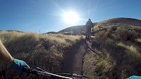
Downhill Only smooth single track with multi-use travel that gets a lot of users. This trail is popular as it connects up to Shane's / 3 Bears / Central Ridge Trail. Thus allowing users to loop in lower/shorter foothill rides or connect up for longer rides via 3 Bears / Shane's

Disclaimer

Downhill Only

Local Trail Association
Traditionally Indigenous Territory

Recent Activity on Trail

Past Week
  • 19 rides
  • 14 miles average
6 Months
  • 312 rides
  • 14 miles avg distance
All
  • 2,515 rides
  • Last: Jun 14, 2026
c1c2c3c4
January
February
March
April
May
June
July
August
September
October
November
December
Status:
on Jun 6, 2026
Dry
Avg: 3.81 (10 votes)
Your vote: 0

view (17,105)
close
3D
Trail Conditions
  • Unknown
  • Snow Groomed
  • Snow Packed
  • Snow Covered
  • Snow Cover Partial
  • Freeze/thaw Cycle
  • Icy
  • Prevalent Mud
  • Wet
  • Variable
  • Ideal
  • Dry
  • Very Dry
Trail Flow (Ridden Direction)
Trailforks scans users ridelogs to determine the most popular direction each trail is ridden. A good flowing trail network will have most trails flowing in a single direction according to their intension.
The colour categories are based on what percentage of riders are riding a trail in its intended direction.
  • > 96%
  • > 90%
  • > 80%
  • > 70%
  • > 50%
  • < 50%
  • bi-directional trail
  • no data
Trail Last Ridden
Trailforks scans ridelogs to determine the last time a trail was ridden.
  • < 2 days
  • < 1 week
  • < 2 weeks
  • < 1 month
  • < 6 months
  • > 6 months
Trail Ridden Direction
The intended direction a trail should be ridden.
  • Downhill Only
  • Downhill Primary
  • Both Directions
  • Uphill Primary
  • Uphill Only
  • One Direction
Contribute Details
Colors indicate trail is missing specified detail.
  • Description
  • Photos
  • Description & Photos
  • Videos
Trail Popularity ?
Trailforks scans ridelogs to determine which trails are ridden the most in the last 9 months. Trails are compared with nearby trails in the same city region with a possible 25 colour shades. Think of this as a heatmap, more rides = more kinetic energy = warmer colors.
  • most popular
  • popular
  • less popular
  • not popular
ATV/ORV/OHV Filter
Max Vehicle Width
inches
US Cell Coverage
Legend
cell carrier legend

Radar Time
Activity Recordings
Trailforks uses anonymized public activity data. ?
Activity Recordings
Trailforks uses anonymized public activity data. ?
Personal Heatmap
Activity Types
all / none
Options
2
Date range month
Winter Trails
Warning A routing network for winter maps does not exist. Selecting trails using the winter trails layer has been disabled.
Missing Trails
Most Popular
Least Popular
Trails are colored based on popularity. The more popular a trail is, the more red. Less popular trails trend towards green.
Jump Magnitude Heatmap
Heatmap of where riders jump on trails. Zoom in to see individual jumps, click circles to view jump details.
BC Backroad Status

Service Road Atlas is a free to use, community-driven service for viewing and creating reports on the numerous back-country service roads around B.C. and Alberta.

map legend
Slope Aspect
Direction the slope faces
Flat N NE E SE S SW W NW
Trails Deemphasized
Trails are shown in grey.
disable
Only show trails with no bike usage.
Enable
Suggested Layers
Based on selected activity type

    Save the current map location and zoom level as your default home location whenever this page is loaded.

    Save
        Directions to bucktail trailhead (43.626860, -116.153450)

        Photos

        9 more »
        52 |
        Oct 6, 2024 @ 7:44am
        Oct 6, 2024
        52 |
        Oct 6, 2024 @ 7:43am
        Oct 6, 2024
        45 |
        Oct 6, 2024 @ 7:43am
        Oct 6, 2024
        41 |
        Jun 22, 2024 @ 7:23pm
        Jun 22, 2024

        Videos

        1 more »
        Trying out the New Gimbal, plus crash
        0:00 | 724 | Nov 8, 2016 , Boise

        Routes with this trail

        7 miles 871 ft 3 Loop
        Ride from Military Reserve trailhead up CCW and down back to trailhead.
        18 miles 2,763 ft 11 Loop
        A pretty good up and down, techy climb from lower hulls on an even day of the week. A high speed downhill...
        3.0 14 miles 2,203 ft 7
        14 mile loop in Boise Heights

        3 Reviews & Comments


        We hope you've been enjoying Trailforks!

        Create a FREE account to view trail comments and much more.

        Frequently Asked Questions About Bucktail

        Where is Bucktail located?
        Bucktail is located in Military Reserve Park, Boise, Idaho, United States. It is part of the Military Reserve Park trail network. The trailhead is located at coordinates 43.62686, -116.15345.
        How hard is Bucktail?
        Bucktail is rated as Green difficulty. The physical rating is Easy. The average grade is 2.7%. The climb difficulty is rated Green.
        What is the elevation gain for Bucktail?
        Bucktail has 26 ft of elevation gain. The trail has 202 ft of elevation descent. The elevation ranges from 3,094 ft to 3,273 ft.
        Is Bucktail a point to point trail?
        Yes, Bucktail is a point to point trail. The direction is Downhill Only. The trail type is singletrack.

        Hit the Trail

        Open in App

        Get this trail on your phone instantly.
        open trail in app

        Download Trail

        Save to wishlist, Garmin & download.
        save the trail

        Find Related Routes

        Find routes and users activities that include this trail.
        find routes for this trail

        You must enter a description before submitting.