1,621 ft
Distance
-300 ft
Descent
00:02:38
Avg time

Bunker Upper Details

  • Activities
    • Mountain Bike
    • E-Bike
    • Hike
    • Trail Running
  • Riding Area
    La Jarosa
    Guadarrama
  • Difficulty Rating
  • Hiking SAC Scale
    T1 Hiking
  • Trail Type
    Singletrack
  • Bike Type
    DH, AM
  • Direction
    Downhill Primary
    Popular direction shown
  • Trail Visibility
    Always easy to follow
  • eBike Allowed
    Yes up to Class 1
  • TTFs on Trail
    Berm, Drop, Rock Face
  • Global Ranking
    #16972 in Mountain Biking [+]
    • #23979 in E-Biking
  • Local Popularity
    90 in Mountain Biking [+]
    • 90 in E-Biking
    • 65 in Trail Running
    • 75 in Hiking

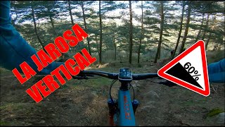
Sendero con algunas secciones muy empinadas, tramos de flow, losas de roca y peraltes naturales.

Access Info

A través del Collado de La Gasca

Disclaimer

Sendero con mucha pendiente. Necesitas buenas condiciones físicas y técnicas para hacerlo con seguridad y sin estropear el trazado.

More Stats for Bunker Upper multi-use trail trail
  • Altitude change
    -300 ft
  • Altitude min
    5,078 ft
  • Altitude max
    5,378 ft
  • Altitude start
    5,378 ft
  • Altitude end
    5,079 ft
  • Grade
    -18.5%
  • Grade max
    -46.6%
  • Grade min
    -3.9%
  • Distance down
    1,621 ft
  • Avg time
    00:02:38
  • view trail stats
Status:
on Jan 18, 2025
Ideal
Avg: 4.39 (4 votes)
Your vote: 0

view (1,195)
close
3D
Trail Conditions
  • Unknown
  • Snow Groomed
  • Snow Packed
  • Snow Covered
  • Snow Cover Partial
  • Freeze/thaw Cycle
  • Icy
  • Prevalent Mud
  • Wet
  • Variable
  • Ideal
  • Dry
  • Very Dry
Trail Flow (Ridden Direction)
Trailforks scans users ridelogs to determine the most popular direction each trail is ridden. A good flowing trail network will have most trails flowing in a single direction according to their intension.
The colour categories are based on what percentage of riders are riding a trail in its intended direction.
  • > 96%
  • > 90%
  • > 80%
  • > 70%
  • > 50%
  • < 50%
  • bi-directional trail
  • no data
Trail Last Ridden
Trailforks scans ridelogs to determine the last time a trail was ridden.
  • < 2 days
  • < 1 week
  • < 2 weeks
  • < 1 month
  • < 6 months
  • > 6 months
Trail Ridden Direction
The intended direction a trail should be ridden.
  • Downhill Only
  • Downhill Primary
  • Both Directions
  • Uphill Primary
  • Uphill Only
  • One Direction
Contribute Details
Colors indicate trail is missing specified detail.
  • Description
  • Photos
  • Description & Photos
  • Videos
Trail Popularity ?
Trailforks scans ridelogs to determine which trails are ridden the most in the last 9 months. Trails are compared with nearby trails in the same city region with a possible 25 colour shades. Think of this as a heatmap, more rides = more kinetic energy = warmer colors.
  • most popular
  • popular
  • less popular
  • not popular
ATV/ORV/OHV Filter
Max Vehicle Width
inches
US Cell Coverage
Legend
cell carrier legend

Radar Time
x Activity Recordings
Trailforks users anonymized public ridelogs from the past 6 months.
  • mountain biking recent
  • mountain biking (>6 month)
  • hiking (1 year)
  • moto (1 year)
Activity Recordings
Trailforks users anonymized public skilogs from the past 12 months.
  • Downhill Ski
  • Backcountry Ski
  • Nordic Ski
  • Snowmobile
Winter Trails
Warning A routing network for winter maps does not exist. Selecting trails using the winter trails layer has been disabled.
x Missing Trails
Most Popular
Least Popular
Trails are colored based on popularity. The more popular a trail is, the more red. Less popular trails trend towards green.
Jump Magnitude Heatmap
Heatmap of where riders jump on trails. Zoom in to see individual jumps, click circles to view jump details.
Trails Deemphasized
Trails are shown in grey.
disable
Only show trails with NO bikes.
enable

Save the current map location and zoom level as your default home location whenever this page is loaded.

Save
      Directions to bunker-upper trailhead (40.695410, -4.143710)

      Recent Ridelog Activity on Trail

      Past Week
      • 2 rides
      • 13 miles avg distance
      6 Months
      • 22 rides
      • 14 miles avg distance
      All
      • 90 rides
      • Last: May 18, 2025

      Photos

      no photos have been added for Bunker Upper yet, add a photo.

      1 Review & Comments


      We hope you've been enjoying Trailforks!

      Create a FREE account to view trail comments and much more.

      Videos

      more »
      youtuber ⏬⏬⏬ Vertical / Bunker◾️ | Puerto de...
      8:15 | 309 | Sep 2, 2021 , Guadarrama
      youtuber  ⛰ Búnker Upper  ◾️ | La Jarosa |...
      4:50 | 134 | Jun 23, 2023 , Guadarrama
      youtuber Corredor XC haciendo Enduro ​ Miguel Díaz |...
      9:48 | 55 | Nov 6, 2023 , Guadarrama
      youtuber Nuevas trialeras   La Jarosa Flow | LIVING...
      8:39 | 64 | May 4, 2023 , Guadarrama
      • By pablo-gloTF Pro & contributors
      • #289972 - 752 views

      You must enter a description before submitting.