


Open in App
Get this trail on your phone instantly.

April 2026 update:
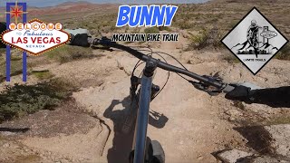
A portion of this trail has been rerouted to avoid one of the steepest, loosest, and more erosive sections of Bunny. This reroute also keeps the trail from entering private land. The new section is well marked with signage. The BLM and SNMBA volunteers worked together to plan and construct this trail upgrade.
| c1 | c2 | c3 | c4 |
|---|---|---|---|
January | February | March | April |
May | June | July | August |
September | October | November | December |

Service Road Atlas is a free to use, community-driven service for viewing and creating reports on the numerous back-country service roads around B.C. and Alberta.
Save the current map location and zoom level as your default home location whenever this page is loaded.
SaveWe hope you've been enjoying Trailforks!
Create a FREE account to view trail comments and much more.
You must enter a description before submitting.

