more stats
3,009 ft
Distance
-155 ft
Descent
00:04:59
Avg time
-155 ft
Altitude change
484 ft
Altitude min
639 ft
Altitude max
639 ft
Altitude start
484 ft
Altitude end
-21.388%
Grade max
-1.526%
Grade min
3,009 ft
Distance down
00:04:59
Avg time

Buzz Lightyear Details

  • Activities
    • Mountain Bike
    • E-Bike
    • Hike
    • Trail Running
  • Riding Area
    Stanmer Park
    Brighton
  • Difficulty Rating
  • Local Popularity
    90 in Mountain Biking [+]
    • 90 in E-Biking
    • 85 in Trail Running
    • 65 in Hiking
  • Global Ranking
    #37570 in Mountain Biking [+]
    • #23638 in E-Biking
    • #20277 in Trail Running
    • #123288 in Hiking
  • Trail Type
    Singletrack
  • Bike Type
    XC
  • Direction
    Both Directions
  • Season
    All Year
  • Dogs Allowed
    Yes
  • eBike Allowed
    Yes up to Class 1
  • Land Owner
    Brighton and Hove City Council

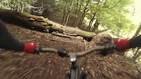
One of the most notorious trails in Stanmer Park, Buzz is a real singletrack skill tester. A healthy mix of flat out corners and tight turns will give even the most competent riders something to think about.

If you're quick you'll find yourself out of breath and near the end in Sub 2min. But the fun's not over here, Buzz leads into a selections of different trails to end with. A swooping trail back to the pylon, a fast paced descent to the farm track or if you can find them a selection of steep and obstacle littered trails down the last hill. There is even a ladder drop if you can find it ;-)

This trail is unsanctioned.

Recent Activity on Trail

Past Week
  • 0 rides
  •  
6 Months
  • 10 rides
  • 13 miles avg distance
All
  • 218 rides
  • Last: Jun 13, 2026
c1c2c3c4
January
February
March
April
May
June
July
August
September
October
November
December
update trails status or condition

Buzz Lightyear Trail Reports

Status:
on Sep 24, 2023
Ideal
Avg: 4.13 (9 votes)
Your vote: 0

view (3,968)
close
3D
Trail Conditions
  • Unknown
  • Snow Groomed
  • Snow Packed
  • Snow Covered
  • Snow Cover Partial
  • Freeze/thaw Cycle
  • Icy
  • Prevalent Mud
  • Wet
  • Variable
  • Ideal
  • Dry
  • Very Dry
Trail Flow (Ridden Direction)
Trailforks scans users ridelogs to determine the most popular direction each trail is ridden. A good flowing trail network will have most trails flowing in a single direction according to their intension.
The colour categories are based on what percentage of riders are riding a trail in its intended direction.
  • > 96%
  • > 90%
  • > 80%
  • > 70%
  • > 50%
  • < 50%
  • bi-directional trail
  • no data
Trail Last Ridden
Trailforks scans ridelogs to determine the last time a trail was ridden.
  • < 2 days
  • < 1 week
  • < 2 weeks
  • < 1 month
  • < 6 months
  • > 6 months
Trail Ridden Direction
The intended direction a trail should be ridden.
  • Downhill Only
  • Downhill Primary
  • Both Directions
  • Uphill Primary
  • Uphill Only
  • One Direction
Contribute Details
Colors indicate trail is missing specified detail.
  • Description
  • Photos
  • Description & Photos
  • Videos
Trail Popularity ?
Trailforks scans ridelogs to determine which trails are ridden the most in the last 9 months. Trails are compared with nearby trails in the same city region with a possible 25 colour shades. Think of this as a heatmap, more rides = more kinetic energy = warmer colors.
  • most popular
  • popular
  • less popular
  • not popular
ATV/ORV/OHV Filter
Max Vehicle Width
inches
US Cell Coverage
Legend
cell carrier legend

Radar Time
Activity Recordings
Trailforks uses anonymized public activity data. ?
Activity Recordings
Trailforks uses anonymized public activity data. ?
Personal Heatmap
Activity Types
all / none
Options
2
Date range month
Winter Trails
Warning A routing network for winter maps does not exist. Selecting trails using the winter trails layer has been disabled.
Missing Trails
Most Popular
Least Popular
Trails are colored based on popularity. The more popular a trail is, the more red. Less popular trails trend towards green.
Jump Magnitude Heatmap
Heatmap of where riders jump on trails. Zoom in to see individual jumps, click circles to view jump details.
BC Backroad Status

Service Road Atlas is a free to use, community-driven service for viewing and creating reports on the numerous back-country service roads around B.C. and Alberta.

map legend
Slope Aspect
Direction the slope faces
Flat N NE E SE S SW W NW
Trails Deemphasized
Trails are shown in grey.
disable
Only show trails with no bike usage.
Enable
Suggested Layers
Based on selected activity type

    Save the current map location and zoom level as your default home location whenever this page is loaded.

    Save
        Directions to buzz-lightyear trailhead (50.887994, -0.109966)

        Photos

        1 more »
        203 |
        Jul 12, 2017 @ 2:08pm
        Jul 12, 2017

        Videos

        3 more »
        The other Day Banshee Rune
        5:21 | 1215 | Sep 23, 2016 , Brighton
        Stamna park ride
        0:07 | 224 | May 18, 2015 , Brighton
        Stamna park ride
        0:17 | 229 | May 18, 2015 , Brighton

        3 Reviews & Comments


        We hope you've been enjoying Trailforks!

        Create a FREE account to view trail comments and much more.

        • #24085 - 5,233 views

        Frequently Asked Questions About Buzz Lightyear

        Where is Buzz Lightyear located?
        Buzz Lightyear is located in Stanmer Park, Brighton, United Kingdom. It is part of the Stanmer Park trail network. The trailhead is located at coordinates 50.88799, -0.10997.
        How hard is Buzz Lightyear?
        Buzz Lightyear is rated as Blue difficulty.
        What is the elevation gain for Buzz Lightyear?
        The trail has 155 ft of elevation descent. The elevation ranges from 484 ft to 639 ft.
        Is Buzz Lightyear a point to point trail?
        Buzz Lightyear is not a point to point trail. The direction is Both Directions. The trail type is singletrack.

        Hit the Trail

        Open in App

        Get this trail on your phone instantly.
        open trail in app

        Download Trail

        Save to wishlist, Garmin & download.
        save the trail

        Find Related Routes

        Find routes and users activities that include this trail.
        find routes for this trail

        You must enter a description before submitting.