more stats
1,837 ft
Distance
31 ft
Climb
-70 ft
Descent
1,996 ft
High Point
-39 ft
Altitude change
1,929 ft
Altitude min
1,987 ft
Altitude start
1,949 ft
Altitude end
-2.1%
Grade
-25.7%
Grade max
14.6%
Grade min
673 ft
Distance climb
915 ft
Distance down
190 ft
Distance flat

Campra Details

  • Activities
    • Mountain Bike
    • Gravel Bike
    • Hike
    • Trail Running
  • Riding Area
  • Ref Number
    B8
  • Difficulty Rating
  • Hiking SAC Scale
    T1 Hiking
  • Trail Exposure
    Normal
  • Trail Type
    Singletrack
  • Bike Type
    AM, XC, Gravel
  • Direction
    Both Directions[+]
    Popular Direction Shown
    • Both Directions for Trail Running
    • Both Directions for Hiking
    • Both Directions for Gravel Biking
  • Trail Visibility
    Always easy to follow
  • eBike Allowed
  • Lighting
    No

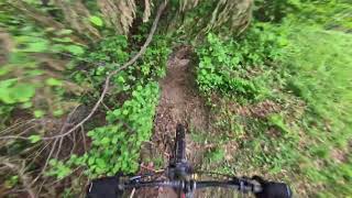
Simpatico sentiero che taglia a valle la regione Campra.

Access Info

Sulla strada principale che porta al Santuario di Graglia, evidente cartello a bordo strada segnala inizio sentiero.

Status:
on May 12, 2026
Ideal
Avg: 3.84 (1 votes)
Your vote: 0

view (10)
close
3D
Trail Conditions
  • Unknown
  • Snow Groomed
  • Snow Packed
  • Snow Covered
  • Snow Cover Partial
  • Freeze/thaw Cycle
  • Icy
  • Prevalent Mud
  • Wet
  • Variable
  • Ideal
  • Dry
  • Very Dry
Trail Flow (Ridden Direction)
Trailforks scans users ridelogs to determine the most popular direction each trail is ridden. A good flowing trail network will have most trails flowing in a single direction according to their intension.
The colour categories are based on what percentage of riders are riding a trail in its intended direction.
  • > 96%
  • > 90%
  • > 80%
  • > 70%
  • > 50%
  • < 50%
  • bi-directional trail
  • no data
Trail Last Ridden
Trailforks scans ridelogs to determine the last time a trail was ridden.
  • < 2 days
  • < 1 week
  • < 2 weeks
  • < 1 month
  • < 6 months
  • > 6 months
Trail Ridden Direction
The intended direction a trail should be ridden.
  • Downhill Only
  • Downhill Primary
  • Both Directions
  • Uphill Primary
  • Uphill Only
  • One Direction
Contribute Details
Colors indicate trail is missing specified detail.
  • Description
  • Photos
  • Description & Photos
  • Videos
Trail Popularity ?
Trailforks scans ridelogs to determine which trails are ridden the most in the last 9 months. Trails are compared with nearby trails in the same city region with a possible 25 colour shades. Think of this as a heatmap, more rides = more kinetic energy = warmer colors.
  • most popular
  • popular
  • less popular
  • not popular
ATV/ORV/OHV Filter
Max Vehicle Width
inches
US Cell Coverage
Legend
cell carrier legend

Radar Time
Activity Recordings
Trailforks uses anonymized public activity data. ?
Activity Recordings
Trailforks uses anonymized public activity data. ?
Personal Heatmap
Activity Types
all / none
Options
2
Date range month
Winter Trails
Warning A routing network for winter maps does not exist. Selecting trails using the winter trails layer has been disabled.
Missing Trails
Most Popular
Least Popular
Trails are colored based on popularity. The more popular a trail is, the more red. Less popular trails trend towards green.
Jump Magnitude Heatmap
Heatmap of where riders jump on trails. Zoom in to see individual jumps, click circles to view jump details.
BC Backroad Status

Service Road Atlas is a free to use, community-driven service for viewing and creating reports on the numerous back-country service roads around B.C. and Alberta.

map legend
Slope Aspect
Direction the slope faces
Flat N NE E SE S SW W NW
Trails Deemphasized
Trails are shown in grey.
disable
Only show trails with no bike usage.
Enable
Suggested Layers
Based on selected activity type

    Save the current map location and zoom level as your default home location whenever this page is loaded.

    Save
        Directions to campra trailhead (45.563860, 7.976300)

        Photos

        No photos have been added for Campra yet, add a photo.

        Videos

        1 more »
        Boscheggia & Campra B8 - Elvo Natural Trail
        5:29 | 43 | Apr 21, 2026 , Graglia

        Reviews / Comments

        No reviews yet, be the first to write a review or ask a question.
        Use trail reports to comment on trail conditions.


        We hope you've been enjoying Trailforks!

        Create a FREE account to view trail comments and much more.

        • By Matt93BITF Pro & contributors
        • #900673 - 173 views

        Frequently Asked Questions About Campra

        Where is Campra located?
        Campra is located in Elvo Natural Trail, Graglia, Italy. It is part of the Elvo Natural Trail trail network. The trailhead is located at coordinates 45.56386, 7.9763.
        How hard is Campra?
        Campra is rated as Green difficulty. The average grade is 2.1%.
        What is the elevation gain for Campra?
        Campra has 9 m of elevation gain. The trail has 21 m of elevation descent. The elevation ranges from 588 m to 608 m.
        Is Campra a point to point trail?
        Campra is not a point to point trail. The direction is Both Directions. The trail type is singletrack.

        Hit the Trail

        Open in App

        Get this trail on your phone instantly.
        open trail in app

        Download Trail

        Save to wishlist, Garmin & download.
        save the trail

        Find Related Routes

        Find routes and users activities that include this trail.
        find routes for this trail

        You must enter a description before submitting.