This trail is permanently closed/decommissioned
more stats
3,274 ft
Distance
23 ft
Climb
-56 ft
Descent
00:06:20
Avg time
-34 ft
Altitude change
350 ft
Altitude min
407 ft
Altitude max
384 ft
Altitude start
351 ft
Altitude end
-1%
Grade
-7.6%
Grade max
13.5%
Grade min
1,089 ft
Distance climb
1,736 ft
Distance down
449 ft
Distance flat
00:06:20
Avg time

Cascara Details

  • Activities
    • Mountain Bike
    • Hike
    • Trail Running
  • Riding Area
  • Difficulty Rating
  • Voted Difficulty
    Green (1 vote)
  • Local Popularity
    95 in Mountain Biking [+]
    • 75 in Trail Running
    • 95 in Hiking
  • Global Ranking
    #59462 in Mountain Biking [+]
    • #133165 in Trail Running
    • #92063 in Hiking
  • State Ranking
    #998 in Mountain Biking · Washington [+]
    • #4,005 in Trail Running
    • #3,428 in Hiking
  • Hiking SAC Scale
    T1 Hiking
  • Trail Type
    Singletrack
  • Bike Type
    XC
  • Climb Difficulty
    Green
  • Physical Rating
    Easy
  • Dogs Allowed
    Yes
  • eBike Allowed
  • Ride in Rain
    Yes

**Trail Closed** The Douglas Fir and Alder trees are being clearcut due to disease. Replanting to occur in 2028, with a reopening close or around year 2029.

Parks Division Director
[email protected]
Ph: 425-388-6616

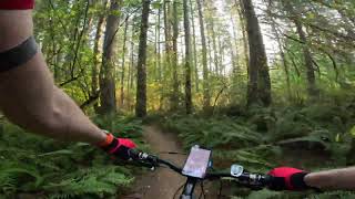
Great trail This is the first single track trail you come to (assuming you started at the main parking lot) and it should not be skipped. Great warm up trail, gets your juices flowing. Nice twists and turn, good rhythm and flow. Enough roots to keep your attention on what's ahead but overall not too roots. There is one rooty corner that some will prefer to walk about a 1/3 of the way in. Be sure to ride it both directions as it's a blast both ways.

Tags
Rooty

Local Trail Association

Traditionally Indigenous Territory

Recent Activity on Trail

Past Week
  • 2 rides
  • 17 miles average
6 Months
  • 378 rides
  • 9 miles avg distance
All
  • 3,450 rides
  • Last: Nov 7, 2026
update trails status or condition

Cascara Trail Reports

Status:
on Oct 29, 2026
Avg: 3.91 (7 votes)
Your vote: 0

view (11,681)
close
      Directions to cascara trailhead (47.787860, -122.087190)

      Photos

      8 more »
      mtb
      65 |
      Nov 10, 2023 @ 1:43am
      Nov 10, 2023
      mtb
      106 |
      Feb 4, 2019 @ 10:24am
      Feb 4, 2019
      mtb
      305 |
      Oct 1, 2015 @ 11:05am
      Oct 1, 2015
      mtb
      345 |
      Sep 25, 2015 @ 12:01pm
      Sep 25, 2015

      Videos

      2 more »
      7 Oct 2022 Cascara Trail, Paradise Valley (4K...
      mtb
      5:48 | 369 | Oct 9, 2022 , Maltby
      Paradise Wa.
      mtb
      14:09 | 269 | Jan 11, 2016 , Maltby

      Routes with this trail

      6 miles • 320 ft • 15 •
      Parking lot to Cascara -> Red Alder -> Ephemeral -> Rogue Fern -> Big Ring & Little Ring ->...
      ★ 4.0 • 7 miles • 462 ft • 17 • Loop •
      All the trails, in the best directions, no repeats.
      ★ 2.8 • 6 miles • 321 ft • 22 • Loop •
      Near-maximum trail coverage, including the most rooty Two Trees South.
      3.9 ★★★★★
      7 Ratings
      5 ★ 29%
      4 ★ 57%
      3 ★
      2 ★
      1 ★ 14%

      1 Review & Comments


      We hope you've been enjoying Trailforks!

      Create a FREE account to view all trail reviews and much more.

      • By palzerTF Pro & contributors
      • #26889 - 4,271 views

      Frequently Asked Questions

      ▼ Where is Cascara located?
      Cascara is located in Paradise Valley Conservation Area, Maltby, Washington, United States. It is part of the Paradise Valley Conservation Area trail network. The trailhead is located at coordinates 47.78786, -122.08719.
      ▼ How hard is Cascara?
      Cascara is rated as Green difficulty. The physical rating is Easy. The average grade is 1%. The climb difficulty is rated Green.
      ▼ What is the elevation gain for Cascara?
      Cascara has 23 ft of elevation gain. The trail has 56 ft of elevation descent. The elevation ranges from 350 ft to 407 ft.
      ▼ How long is Cascara?
      Cascara is 3,274 ft long. The trail type is singletrack.
      ▼ Are dogs allowed on Cascara?
      Yes, dogs are allowed on Cascara. Please keep dogs on a leash where required and clean up after them.
      ▼ How do I access Cascara? Where is the closest parking trailhead?
      The closest parking and trailhead locations to Cascara are: View all parking locations in the area.
      ▼ How long does it take to ride Cascara?
      Based on recorded activities, it takes an average of 6 minutes to ride Cascara. The trail is 3,274 ft long. Actual times will vary based on fitness level, conditions, and pace. View recent activity logs for more details.
      ▼ How busy is Cascara?
      Cascara is a very popular trail. There have been 11,104 recorded activities on this trail. The trail has received 11,681 check-ins. View recent activity on this trail.

      Hit the Trail

      Open in App

      Get this trail on your phone instantly.

      open trail in app

      Download Trail

      Save to wishlist, Garmin & download.
      save the trail

      Find Related Routes

      Find routes and users activities that include this trail.
      find routes for this trail

      You must enter a description before submitting.