1.1 miles
Distance
-1,077 ft
Descent
00:13:46
Avg time
Catapult Ranch Details
-
Activities
- Mountain Bike
-
Riding AreaBig White Mountain
Kelowna, British Columbia -
AKADH Course
-
Difficulty Rating
-
Trail TypeSingletrack
-
Bike TypeDH, AM
-
DirectionDownhill OnlyPopular direction shown
-
TTFs on TrailBridge, Drop, Jump, Gap Jump, Rock Face, Rock Garden
-
Global Ranking#35849 in Mountain Biking
-
Local Popularity55 in Mountain Biking
-
Year Opened2017
-
Land Owner
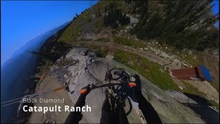
Initially built for the Big White BC Cup event.
Has now been converted to make it open to the public. Still gnarly lines and great ride
Naming Story: The name speaks for itself. A few chances to go Over the Bars. Pick your lines carefully.
Traditionally Indigenous Territory
More Stats for Catapult Ranch mountain bike trail trail
-
Altitude change-1,077 ft
-
Altitude min5,970 ft
-
Altitude max7,047 ft
-
Altitude start7,047 ft
-
Altitude end5,971 ft
-
Grade-18.2%
-
Grade max-62.1%
-
Grade min-1.7%
-
Distance down1 mile
-
Avg time00:13:46
-
Avg reverse time00:25:25
- view trail stats
close
3D
Trail Conditions
- Unknown
- Snow Groomed
- Snow Packed
- Snow Covered
- Snow Cover Inadequate
- Freeze/thaw Cycle
- Icy
- Prevalent Mud
- Wet
- Variable
- Ideal
- Dry
- Very Dry
Trail Flow (Ridden Direction)
Trailforks scans users ridelogs to determine the most popular direction each trail is ridden. A good flowing trail network will have most trails flowing in a single direction according to their intension.
The colour categories are based on what percentage of riders are riding a trail in its intended direction.
- > 96%
- > 90%
- > 80%
- > 70%
- > 50%
- < 50%
- bi-directional trail
- no data
Trail Last Ridden
Trailforks scans ridelogs to determine the last time a trail was ridden.
- < 2 days
- < 1 week
- < 2 weeks
- < 1 month
- < 6 months
- > 6 months
Trail Ridden Direction
The intended direction a trail should be ridden.
- Downhill Only
- Downhill Primary
- Both Directions
- Uphill Primary
- Uphill Only
- One Direction
Contribute Details
Colors indicate trail is missing specified detail.
- Description
- Photos
- Description & Photos
- Videos
Trail Popularity ?
Trailforks scans ridelogs to determine which trails are ridden the most in the last 9 months.
Trails are compared with nearby trails in the same city region with a possible 25 colour shades.
Think of this as a heatmap, more rides = more kinetic energy = warmer colors.
- most popular
- popular
- less popular
- not popular
ATV/ORV/OHV Filter
Max Vehicle Width
inches
Radar Time
x
Activity Recordings
Trailforks users anonymized public ridelogs from the past 6 months.
- mountain biking recent
- mountain biking (>6 month)
- hiking (1 year)
- moto (1 year)
Activity Recordings
Trailforks users anonymized public skilogs from the past 12 months.
- Downhill Ski
- Backcountry Ski
- Nordic Ski
- Snowmobile
Jump Magnitude Heatmap
Heatmap of where riders jump on trails. Zoom in to see individual jumps, click circles to view jump details.
Trails Deemphasized
Trails are shown in grey.
Only show trails with NO bikes.
Save the current map location and zoom level as your default home location whenever this page is loaded.
Save
Directions to catapult-ranch trailhead
(49.738070, -118.930620)
update trails status or condition
Catapult Ranch Trail Reports
view all reports »
Recent Ridelog Activity on Trail
Past Week
- 0 rides
6 Months
- 0 rides
All
- 381 rides
- Last: Aug 6, 2022
Photos
more »
Routes with this trail
3 Reviews & Comments
-
+ 0

This trail is actually rated a double black up at big white, and knockout is rated a single black
[Reply]


Hope this trail is open for the last day of the season after the DH race.
[Reply]
Videos
more »
youtuber

5:42 |
406 |
Nov 5, 2021 , Kelowna
Nearby Trails
- Sundance 62 ft
- Bumble Bee 118 ft
- Pry Bar 121 ft
- Rock Hammer 121 ft
- Sun Run 131 ft
- embed Catapult Ranch trail on your website
- By bikebigwhite
BWTC & contributors
- #100482 - 6,320 views
- subscribe
- login to download gpx or kml files.