more stats
826 ft
Distance
-160 ft
Descent
00:04:04
Avg time
-160 ft
Altitude change
522 ft
Altitude min
682 ft
Altitude max
682 ft
Altitude start
522 ft
Altitude end
-19.377%
Grade
-27.099%
Grade max
-6.04%
Grade min
826 ft
Distance down
00:04:04
Avg time

CDL Details

  • Activities
    • Mountain Bike
    • E-Bike
  • Riding Area
    Stile Cop
    Rugeley
  • Difficulty Rating
  • Local Popularity
    60 in Mountain Biking [+]
    • 75 in E-Biking
  • Global Ranking
    #62986 in Mountain Biking [+]
    • #48210 in E-Biking
  • Trail Type
    Singletrack
  • Bike Type
    DH, AM
  • Direction
    Downhill Only
  • Dogs Allowed
    Yes
  • eBike Allowed
    Yes up to Class 1
  • TTFs on Trail
    Berm, Drop, Jump
  • Ride in Rain
    Yes
  • Land Owner

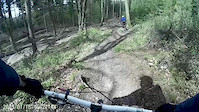
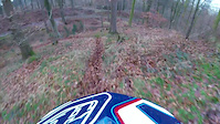
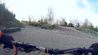
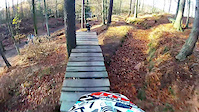
First left option off the red course, to start it gets tighter and steeper then the Red course. The over the ‘gas line’ and into some off camber roots and flatter corners. Drop off the tree stump and into a fast rooty rattle. Jump towards the fire road then hit the tight Red course finish.

source: Stile Cop
Local Trail Association

Recent Activity on Trail

Past Week
  • 0 rides
  •  
6 Months
  • 10 rides
  • 7 miles avg distance
All
  • 112 rides
  • Last: May 29, 2026
c1c2c3c4
January
February
March
April
May
June
July
August
September
October
November
December
Status:
on Oct 14, 2024
Variable
Avg: 3.85 (8 votes)
Your vote: 0

view (4,262)
close
3D
Trail Conditions
  • Unknown
  • Snow Groomed
  • Snow Packed
  • Snow Covered
  • Snow Cover Partial
  • Freeze/thaw Cycle
  • Icy
  • Prevalent Mud
  • Wet
  • Variable
  • Ideal
  • Dry
  • Very Dry
Trail Flow (Ridden Direction)
Trailforks scans users ridelogs to determine the most popular direction each trail is ridden. A good flowing trail network will have most trails flowing in a single direction according to their intension.
The colour categories are based on what percentage of riders are riding a trail in its intended direction.
  • > 96%
  • > 90%
  • > 80%
  • > 70%
  • > 50%
  • < 50%
  • bi-directional trail
  • no data
Trail Last Ridden
Trailforks scans ridelogs to determine the last time a trail was ridden.
  • < 2 days
  • < 1 week
  • < 2 weeks
  • < 1 month
  • < 6 months
  • > 6 months
Trail Ridden Direction
The intended direction a trail should be ridden.
  • Downhill Only
  • Downhill Primary
  • Both Directions
  • Uphill Primary
  • Uphill Only
  • One Direction
Contribute Details
Colors indicate trail is missing specified detail.
  • Description
  • Photos
  • Description & Photos
  • Videos
Trail Popularity ?
Trailforks scans ridelogs to determine which trails are ridden the most in the last 9 months. Trails are compared with nearby trails in the same city region with a possible 25 colour shades. Think of this as a heatmap, more rides = more kinetic energy = warmer colors.
  • most popular
  • popular
  • less popular
  • not popular
ATV/ORV/OHV Filter
Max Vehicle Width
inches
US Cell Coverage
Legend
cell carrier legend

Radar Time
Activity Recordings
Trailforks uses anonymized public activity data. ?
Activity Recordings
Trailforks uses anonymized public activity data. ?
Personal Heatmap
Activity Types
all / none
Options
2
Date range month
Winter Trails
Warning A routing network for winter maps does not exist. Selecting trails using the winter trails layer has been disabled.
Missing Trails
Most Popular
Least Popular
Trails are colored based on popularity. The more popular a trail is, the more red. Less popular trails trend towards green.
Jump Magnitude Heatmap
Heatmap of where riders jump on trails. Zoom in to see individual jumps, click circles to view jump details.
BC Backroad Status

Service Road Atlas is a free to use, community-driven service for viewing and creating reports on the numerous back-country service roads around B.C. and Alberta.

map legend
Slope Aspect
Direction the slope faces
Flat N NE E SE S SW W NW
Trails Deemphasized
Trails are shown in grey.
disable
Only show trails with no bike usage.
Enable
Suggested Layers
Based on selected activity type

    Save the current map location and zoom level as your default home location whenever this page is loaded.

    Save
        Directions to cdl trailhead (52.734055, -1.949491)

        Photos

        735 more »
        112 |
        Aug 31, 2017 @ 10:31am
        Aug 31, 2017
        137 |
        Aug 31, 2017 @ 10:31am
        Aug 31, 2017
        154 |
        Mar 29, 2008 @ 10:09am
        Mar 29, 2008
        84 |
        Mar 29, 2008 @ 10:10am
        Mar 29, 2008

        Videos

        16 more »
        Cannock
        2:02 | 51 | Apr 30, 2015 , Rugeley
        Stile Cop CDL into Mini Mega
        0:53 | 157 | Jan 16, 2018 , Rugeley
        Stile Cop - 12th January 2014
        3:39 | 182 | May 31, 2014 , Rugeley
        Stile Cop - November 2013
        4:26 | 398 | Nov 30, 2013 , Rugeley

        Routes with this trail

        1,572 ft 6 Point to Point Race
        Race route for the Racers Guild Racing events. A&E.
        1,467 ft 5 Point to Point Race
        Race route for the Racers Guild Racing events. CDL.

        Reviews / Comments

        No reviews yet, be the first to write a review or ask a question.
        Use trail reports to comment on trail conditions.


        We hope you've been enjoying Trailforks!

        Create a FREE account to view trail comments and much more.

        Frequently Asked Questions About CDL

        Where is CDL located?
        CDL is located in Stile Cop, Rugeley, United Kingdom. It is part of the Stile Cop trail network. The trailhead is located at coordinates 52.73406, -1.94949.
        How hard is CDL?
        CDL is rated as Black difficulty. The average grade is 19.377%.
        What is the elevation gain for CDL?
        The trail has 160 ft of elevation descent. The elevation ranges from 522 ft to 682 ft.
        Is CDL a point to point trail?
        Yes, CDL is a point to point trail. The direction is Downhill Only. The trail type is singletrack.

        Hit the Trail

        Open in App

        Get this trail on your phone instantly.
        open trail in app

        Download Trail

        Save to wishlist, Garmin & download.
        save the trail

        Find Related Routes

        Find routes and users activities that include this trail.
        find routes for this trail

        You must enter a description before submitting.