more stats
650 ft
Distance
-128 ft
Descent
00:03:49
Avg time
-128 ft
Altitude change
295 ft
Altitude min
423 ft
Altitude max
423 ft
Altitude start
295 ft
Altitude end
-19.7%
Grade
-56.7%
Grade max
-5.3%
Grade min
650 ft
Distance down
00:03:49
Avg time

Cervecera Details

  • Activities
    • Mountain Bike
    • E-Bike
    • Hike
    • Trail Running
  • Riding Area
    Eskumaldea
    Getxo
  • Difficulty Rating
  • Local Popularity
    45 in Mountain Biking [+]
    • 40 in E-Biking
    • 85 in Trail Running
    • 5 in Hiking
  • Global Ranking
    #146651 in Mountain Biking [+]
    • #130261 in E-Biking
    • #72583 in Trail Running
    • #293426 in Hiking
  • National Ranking
    #13,242 in Mountain Biking · Spain [+]
    • #29,315 in E-Biking
    • #5,789 in Trail Running
    • #28,983 in Hiking
  • Trail Type
    Singletrack
  • Bike Type
    AM, XC
  • Direction
    Downhill Primary
    Popular Direction Shown
  • Physical Rating
    Easy
  • Trail Visibility
    Always easy to follow
  • Season
    Todas
  • Dogs Allowed
    Yes
  • eBike Allowed
    Yes up to Class 1
  • TTFs on Trail
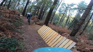
    Drop, Jump, Gap Jump, Roller Coaster

Antiguo sendero de bajada, muy degradado

Tags
DropsJumpsRollers

Local Trail Association

Recent Activity on Trail

Past Week
  • 1 rides
  • 18 miles average
6 Months
  • 7 rides
  • 16 miles avg distance
All
  • 81 rides
  • Last: Nov 3, 2026
update trails status or condition

Cervecera Trail Reports

statusdatedescription
Nov 15, 2023 @ 7:43am
Nov 15, 2023
Suelen cerrar el acceso al sendero final, lo he abierto varias veces.
Apr 5, 2023 @ 6:20am
Apr 5, 2023
reporter El reporte anterior corresponde al corte de un árbol que tapaba la parte del sendero que se ha salvado de las talas de la parte superior, pero...
Apr 5, 2023 @ 12:28am
Apr 5, 2023
reporter
Liberado el salto de hormigón….cortados un par de arboles que lo cerraban
Dec 1, 2022 @ 11:53pm
Dec 1, 2022
reporter cerrado por talas
Dec 1, 2022 @ 1:31pm
Dec 1, 2022
Sendero arrasado por la tala ☹️
more »
Status:
on Nov 15, 2023
Variable
Avg: 3.99 (3 votes)
Your vote: 0

view (216)
close
      Directions to cervecera trailhead (43.335940, -2.941080)

      Photos

      15 more »
      mtb
      166 |
      Jul 5, 2020 @ 10:08pm
      Jul 5, 2020
      mtb
      158 |
      Jul 15, 2020 @ 2:01am
      Jul 15, 2020
      mtb
      136 |
      Jul 5, 2020 @ 10:08pm
      Jul 5, 2020
      mtb
      189 |
      Jun 11, 2020 @ 5:25am
      Jun 11, 2020

      Videos

      2 more »
      DH Cervecera Unbe tras Edu RAW
      mtb
      2:07 | 543 | Nov 27, 2020 , Getxo
      Salto gordo segunda parte
      mtb
      0:12 | 153 | Sep 20, 2020 , Getxo
      4.0 ★★★★★
      3 Ratings
      5 ★ 67%
      4 ★
      3 ★
      2 ★ 33%
      1 ★

      4 Reviews & Comments

      nixon94
      Hoy he ido para probar y esta arrasado por tala de arboles ya no existe

      We hope you've been enjoying Trailforks!

      Create a FREE account to view all trail reviews and much more.

      • By kisuare & contributors
      • #190022 - 2,204 views

      Frequently Asked Questions

      ▼ Where is Cervecera located?
      Cervecera is located in Eskumaldea, Getxo, Spain. It is part of the Eskumaldea trail network. The trailhead is located at coordinates 43.33594, -2.94108.
      ▼ How hard is Cervecera?
      Cervecera is rated as Red difficulty. The physical rating is Easy. The average grade is 19.7%.
      ▼ What is the elevation gain for Cervecera?
      The trail has 128 ft of elevation descent. The elevation ranges from 295 ft to 423 ft.
      ▼ Is Cervecera a point to point trail?
      Cervecera is not a point to point trail. The direction is Downhill Primary. The trail type is singletrack.
      ▼ How long is Cervecera?
      Cervecera is 650 ft long. The trail type is singletrack.
      ▼ Are dogs allowed on Cervecera?
      Yes, dogs are allowed on Cervecera. Please keep dogs on a leash where required and clean up after them.
      ▼ When is the best time of year to ride Cervecera?
      Cervecera is best visited during: Todas.
      ▼ How do I access Cervecera? Where is the closest parking trailhead?
      The closest parking and trailhead locations to Cervecera are: View all parking locations in the area.
      ▼ How long does it take to ride Cervecera?
      Based on recorded activities, it takes an average of 4 minutes to ride Cervecera. The trail is 650 ft long. Actual times will vary based on fitness level, conditions, and pace. View recent activity logs for more details.
      ▼ How busy is Cervecera?
      Cervecera is a moderately popular trail. There have been 211 recorded activities on this trail. The trail has received 216 check-ins. View recent activity on this trail.

      Hit the Trail

      Open in App

      Get this trail on your phone instantly.

      open trail in app

      Download Trail

      Save to wishlist, Garmin & download.
      save the trail

      Find Related Routes

      Find routes and users activities that include this trail.
      find routes for this trail

      You must enter a description before submitting.