more stats
4,360 ft
Distance
39 ft
Climb
-361 ft
Descent
00:21:59
Avg time
-322 ft
Altitude change
4,354 ft
Altitude min
4,677 ft
Altitude max
4,677 ft
Altitude start
4,357 ft
Altitude end
-7.4%
Grade
-77.4%
Grade max
11.8%
Grade min
1,102 ft
Distance climb
2,825 ft
Distance down
433 ft
Distance flat
00:21:59
Avg time

Chorrera Details

  • Activities
    • Mountain Bike
    • E-Bike
    • Hike
    • Trail Running
  • Riding Area
  • Ref Number
    #1
  • Difficulty Rating
  • Local Popularity
    65 in Mountain Biking [+]
    • 60 in E-Biking
    • 5 in Trail Running
    • 100 in Hiking
  • Global Ranking
    #25851 in Mountain Biking [+]
    • #72229 in E-Biking
    • #188601 in Trail Running
    • #42336 in Hiking
  • Hiking SAC Scale
    T1 Hiking
  • Trail Type
    Singletrack
  • Bike Type
    AM, XC
  • Direction
    Downhill Primary
    Popular Direction Shown
  • Climb Difficulty
    Green
  • Physical Rating
    Moderate
  • Trail Visibility
    Sometimes hard to follow
  • Dogs Allowed
    Yes
  • eBike Allowed
    Yes up to Class 1
  • TTFs on Trail
    Bridge

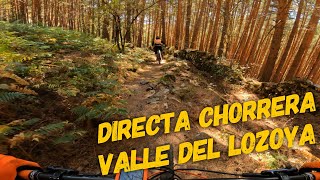
Sendero creado por la subida hasta la Chorrera de San Manes, la bajada comienza con una zona rapida entre pinos y con algún paso de trialera, llegas a un paso para cruzar el arroyo y un pequeño empukabike de unos metros con una esclara de piedras para seguir bajando hasta el final del minar, al salir del pinar cogemos el sendero hacia Navarredonda (a la izquierda) y subimos por un sendero entre jaras a media ladera para seguir bajando por sendero poco dibujado hasta la pista

Recent Activity on Trail

Past Week
  • 0 rides
  •  
6 Months
  • 2 rides
  • 13 miles avg distance
All
  • 6 rides
  • Last: Jun 14, 2026
c1c2c3c4
January
February
March
April
May
June
July
August
September
October
November
December
update trails status or condition

Chorrera Trail Reports

statusdatedescription
Sep 10, 2022 @ 6:56am
Sep 10, 2022
Some fallen trees across the trail at the beginning
Aug 20, 2022 @ 4:57am
Aug 20, 2022
more »
Status:
on Sep 10, 2022
Variable
Avg: 3.98 (1 votes)
Your vote: 0

view (26)
close
3D
Trail Conditions
  • Unknown
  • Snow Groomed
  • Snow Packed
  • Snow Covered
  • Snow Cover Partial
  • Freeze/thaw Cycle
  • Icy
  • Prevalent Mud
  • Wet
  • Variable
  • Ideal
  • Dry
  • Very Dry
Trail Flow (Ridden Direction)
Trailforks scans users ridelogs to determine the most popular direction each trail is ridden. A good flowing trail network will have most trails flowing in a single direction according to their intension.
The colour categories are based on what percentage of riders are riding a trail in its intended direction.
  • > 96%
  • > 90%
  • > 80%
  • > 70%
  • > 50%
  • < 50%
  • bi-directional trail
  • no data
Trail Last Ridden
Trailforks scans ridelogs to determine the last time a trail was ridden.
  • < 2 days
  • < 1 week
  • < 2 weeks
  • < 1 month
  • < 6 months
  • > 6 months
Trail Ridden Direction
The intended direction a trail should be ridden.
  • Downhill Only
  • Downhill Primary
  • Both Directions
  • Uphill Primary
  • Uphill Only
  • One Direction
Contribute Details
Colors indicate trail is missing specified detail.
  • Description
  • Photos
  • Description & Photos
  • Videos
Trail Popularity ?
Trailforks scans ridelogs to determine which trails are ridden the most in the last 9 months. Trails are compared with nearby trails in the same city region with a possible 25 colour shades. Think of this as a heatmap, more rides = more kinetic energy = warmer colors.
  • most popular
  • popular
  • less popular
  • not popular
ATV/ORV/OHV Filter
Max Vehicle Width
inches
US Cell Coverage
Legend
cell carrier legend

Radar Time
Activity Recordings
Trailforks uses anonymized public activity data. ?
Activity Recordings
Trailforks uses anonymized public activity data. ?
Personal Heatmap
Activity Types
all / none
Options
2
Date range month
Winter Trails
Warning A routing network for winter maps does not exist. Selecting trails using the winter trails layer has been disabled.
Missing Trails
Most Popular
Least Popular
Trails are colored based on popularity. The more popular a trail is, the more red. Less popular trails trend towards green.
Jump Magnitude Heatmap
Heatmap of where riders jump on trails. Zoom in to see individual jumps, click circles to view jump details.
BC Backroad Status

Service Road Atlas is a free to use, community-driven service for viewing and creating reports on the numerous back-country service roads around B.C. and Alberta.

map legend
Slope Aspect
Direction the slope faces
Flat N NE E SE S SW W NW
Trails Deemphasized
Trails are shown in grey.
disable
Only show trails with no bike usage.
Enable
Suggested Layers
Based on selected activity type

    Save the current map location and zoom level as your default home location whenever this page is loaded.

    Save
        Directions to chorrera trailhead (41.015160, -3.731600)

        Photos

        No photos have been added for Chorrera yet, add a photo.

        Videos

        1 more »
        youtuber ‍♂️ ⛰ Directa Chorrera  | San Mamés...
        7:26 | 137 | Sep 19, 2022 , Lozoya

        Routes with this trail

        4.0 20 miles 3,064 ft 9 Loop
        Ruta circular con gran parte de pista y camino, sobretodo las subidas y un par de bajadas por sendero...

        1 Review & Comments


        We hope you've been enjoying Trailforks!

        Create a FREE account to view trail comments and much more.

        • By allmountainmadridTF Pro & contributors
        • #558150 - 290 views

        Frequently Asked Questions About Chorrera

        Where is Chorrera located?
        Chorrera is located in Valle del Lozoya, Lozoya, Spain. It is part of the Valle del Lozoya trail network. The trailhead is located at coordinates 41.01516, -3.7316.
        How hard is Chorrera?
        Chorrera is rated as Blue difficulty. The physical rating is Moderate. The average grade is 7.4%. The climb difficulty is rated Green.
        What is the elevation gain for Chorrera?
        Chorrera has 39 ft of elevation gain. The trail has 361 ft of elevation descent. The elevation ranges from 4,354 ft to 4,677 ft.
        Is Chorrera a point to point trail?
        Chorrera is not a point to point trail. The direction is Downhill Primary. The trail type is singletrack.

        Hit the Trail

        Open in App

        Get this trail on your phone instantly.
        open trail in app

        Download Trail

        Save to wishlist, Garmin & download.
        save the trail

        Find Related Routes

        Find routes and users activities that include this trail.
        find routes for this trail

        You must enter a description before submitting.