more stats
5,066 ft
Distance
3 ft
Climb
-1,161 ft
Descent
3,427 ft
High Point
-1,158 ft
Altitude change
2,266 ft
Altitude min
3,427 ft
Altitude start
2,270 ft
Altitude end
-22.9%
Grade
-78.3%
Grade max
-3.9%
Grade min
26 ft
Distance climb
5,039 ft
Distance down

Clemone Details

  • Activities
    • Mountain Bike
    • E-Bike
    • Hike
    • Trail Running
  • Riding Area
  • Difficulty Rating
  • Local Popularity
    75 in Mountain Biking [+]
    • 70 in E-Biking
    • 5 in Trail Running
    • 5 in Hiking
  • Global Ranking
    #183074 in Mountain Biking [+]
    • #50562 in E-Biking
    • #157149 in Trail Running
    • #153448 in Hiking
  • Trail Type
    Singletrack
  • Bike Type
    DH, AM
  • Direction
    Downhill Only
    Popular Direction Shown
  • Physical Rating
    Moderate
  • Trail Visibility
    Always easy to follow
  • Season
    March - November
  • Alpine Trail
    Yes
  • eBike Allowed
  • TTFs on Trail
    Rock Face, Rock Garden

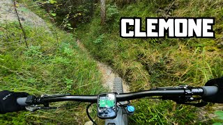
Alternating techy and flowy parts. Loose rocks and steep rock faces.

Access Info

From Strada Militare 106 drop into “Tregadone Grande“ trail. Then stay left at a junction.

Recent Activity on Trail

Past Week
  • 0 rides
  •  
6 Months
  • 0 rides
  •  
All
  • 2 rides
  • Last: Oct 2, 2025
update trails status or condition

Clemone Trail Reports

statusdatedescription
Apr 8, 2026 @ 12:09pm (Europe/Rome)
Apr 8, 2026
L'albero caduto si supera senza troppe complicazioni
Mar 1, 2025 @ 10:46pm
Mar 1, 2025
Si conferma albero caduto nella parte alta. Parte finale incassata nel letto di un ruscello, gradoni di roccia, sassi smossi e difficoltà a...
Oct 22, 2024 @ 9:34am
Oct 22, 2024
Big fallen tree in the upper part. In the lower part there are a lot of loose stones that have fallen on the singletrack and in one place make the...
more »
Status:
on Apr 8, 2026
Ideal
Avg: 3.99 (1 votes)
Your vote: 0

view (11)
close
3D
Trail Conditions
  • Unknown
  • Snow Groomed
  • Snow Packed
  • Snow Covered
  • Snow Cover Partial
  • Freeze/thaw Cycle
  • Icy
  • Prevalent Mud
  • Wet
  • Variable
  • Ideal
  • Dry
  • Very Dry
Trail Flow (Ridden Direction)
Trailforks scans users ridelogs to determine the most popular direction each trail is ridden. A good flowing trail network will have most trails flowing in a single direction according to their intension.
The colour categories are based on what percentage of riders are riding a trail in its intended direction.
  • > 96%
  • > 90%
  • > 80%
  • > 70%
  • > 50%
  • < 50%
  • bi-directional trail
  • no data
Trail Last Ridden
Trailforks scans ridelogs to determine the last time a trail was ridden.
  • < 2 days
  • < 1 week
  • < 2 weeks
  • < 1 month
  • < 6 months
  • > 6 months
Trail Ridden Direction
The intended direction a trail should be ridden.
  • Downhill Only
  • Downhill Primary
  • Both Directions
  • Uphill Primary
  • Uphill Only
  • One Direction
Contribute Details
Colors indicate trail is missing specified detail.
  • Description
  • Photos
  • Description & Photos
  • Videos
Trail Popularity ?
Trailforks scans ridelogs to determine which trails are ridden the most in the last 9 months. Trails are compared with nearby trails in the same city region with a possible 25 colour shades. Think of this as a heatmap, more rides = more kinetic energy = warmer colors.
  • most popular
  • popular
  • less popular
  • not popular
ATV/ORV/OHV Filter
Max Vehicle Width
inches
US Cell Coverage
Legend
cell carrier legend

Radar Time
Activity Recordings
Trailforks uses anonymized public activity data. ?
Activity Recordings
Trailforks uses anonymized public activity data. ?
Personal Heatmap
Activity Types
all / none
Options
2
Date range month
Winter Trails
Warning A routing network for winter maps does not exist. Selecting trails using the winter trails layer has been disabled.
Missing Trails
Most Popular
Least Popular
Trails are colored based on popularity. The more popular a trail is, the more red. Less popular trails trend towards green.
Jump Magnitude Heatmap
Heatmap of where riders jump on trails. Zoom in to see individual jumps, click circles to view jump details.
BC Backroad Status

Service Road Atlas is a free to use, community-driven service for viewing and creating reports on the numerous back-country service roads around B.C. and Alberta.

map legend
Slope Aspect
Direction the slope faces
Flat N NE E SE S SW W NW
Trails Deemphasized
Trails are shown in grey.
disable
Only show trails with no bike usage.
Enable
Suggested Layers
Based on selected activity type

    Save the current map location and zoom level as your default home location whenever this page is loaded.

    Save
        Directions to clemone trailhead (45.816400, 10.745580)

        Photos

        14 more »
        35 |
        Feb 26, 2025 @ 11:58pm
        Feb 26, 2025
        41 |
        Feb 26, 2025 @ 11:58pm
        Feb 26, 2025
        32 |
        Oct 22, 2024 @ 9:24am
        Oct 22, 2024
        34 |
        Oct 22, 2024 @ 9:24am
        Oct 22, 2024

        Videos

        2 more »
        CLEMONE - Wild, flow and tecky singletrack
        6:42 | 122 | Oct 22, 2024 , Tremosine
        Clemone POV
        8:36 | 67 | Apr 30, 2024 , Tremosine

        6 Reviews & Comments


        We hope you've been enjoying Trailforks!

        Create a FREE account to view trail comments and much more.

        • By DavidLagoFreeriderTF Pro & contributors
        • #231745 - 697 views

        Frequently Asked Questions About Clemone

        Where is Clemone located?
        Clemone is located in Tremosine, Italy. It is part of the Tremosine trail network. The trailhead is located at coordinates 45.8164, 10.74558.
        How hard is Clemone?
        Clemone is rated as Red difficulty. The physical rating is Moderate. The average grade is 22.9%.
        What is the elevation gain for Clemone?
        Clemone has 1 m of elevation gain. The trail has 354 m of elevation descent. The elevation ranges from 691 m to 1,045 m.
        Is Clemone a point to point trail?
        Yes, Clemone is a point to point trail. The direction is Downhill Only. The trail type is singletrack.

        Hit the Trail

        Open in App

        Get this trail on your phone instantly.
        open trail in app

        Download Trail

        Save to wishlist, Garmin & download.
        save the trail

        Find Related Routes

        Find routes and users activities that include this trail.
        find routes for this trail

        You must enter a description before submitting.