more stats
3,159 ft
Distance
3 ft
Climb
-493 ft
Descent
00:05:09
Avg time
-491 ft
Altitude change
3,486 ft
Altitude min
3,977 ft
Altitude max
3,977 ft
Altitude start
3,488 ft
Altitude end
-15.5%
Grade
-31.8%
Grade max
1.9%
Grade min
26 ft
Distance climb
2,946 ft
Distance down
190 ft
Distance flat
00:05:09
Avg time

Coaster Details

  • Activities
    • Mountain Bike
    • E-Bike
  • Riding Area
    Valemount Bike Park
    Valemount, British Columbia
  • Difficulty Rating
  • Local Popularity
    90 in Mountain Biking [+]
    • 85 in E-Biking
  • Global Ranking
    #41819 in Mountain Biking [+]
    • #35253 in E-Biking
  • Trail Type
    Singletrack
  • Bike Type
    DH, AM
  • Direction
    Downhill Only
    Popular Direction Shown
  • Physical Rating
    Moderate
  • Season
    May - Oct
  • Dogs Allowed
    Yes
  • eBike Allowed
  • TTFs on Trail
    Berm, Bridge, Drop, Gap Jump, Ladder Bridge
  • Year Opened
    2017
  • Land Owner

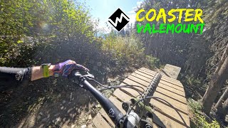
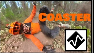
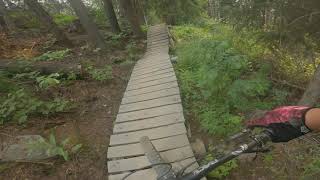
Hand built downhill trail with a variety of wooden and dirt features.

Access Info

Ride Munday Grind to trailhead shared with Andreas' and Tinfoil. Look for the 'Alice the Camel' wood feature near the start of Andreas'

Bike Park

Recent Activity on Trail

Past Week
  • 3 rides
  • 6 miles average
6 Months
  • 7 rides
  • 18 miles avg distance
All
  • 276 rides
  • Last: Jun 5, 2026
c1c2c3c4
January
February
March
April
May
June
July
August
September
October
November
December
Status:
on Apr 28, 2026
Variable
Avg: 4.26 (18 votes)
Your vote: 0

view (1,762)
close
3D
Trail Conditions
  • Unknown
  • Snow Groomed
  • Snow Packed
  • Snow Covered
  • Snow Cover Partial
  • Freeze/thaw Cycle
  • Icy
  • Prevalent Mud
  • Wet
  • Variable
  • Ideal
  • Dry
  • Very Dry
Trail Flow (Ridden Direction)
Trailforks scans users ridelogs to determine the most popular direction each trail is ridden. A good flowing trail network will have most trails flowing in a single direction according to their intension.
The colour categories are based on what percentage of riders are riding a trail in its intended direction.
  • > 96%
  • > 90%
  • > 80%
  • > 70%
  • > 50%
  • < 50%
  • bi-directional trail
  • no data
Trail Last Ridden
Trailforks scans ridelogs to determine the last time a trail was ridden.
  • < 2 days
  • < 1 week
  • < 2 weeks
  • < 1 month
  • < 6 months
  • > 6 months
Trail Ridden Direction
The intended direction a trail should be ridden.
  • Downhill Only
  • Downhill Primary
  • Both Directions
  • Uphill Primary
  • Uphill Only
  • One Direction
Contribute Details
Colors indicate trail is missing specified detail.
  • Description
  • Photos
  • Description & Photos
  • Videos
Trail Popularity ?
Trailforks scans ridelogs to determine which trails are ridden the most in the last 9 months. Trails are compared with nearby trails in the same city region with a possible 25 colour shades. Think of this as a heatmap, more rides = more kinetic energy = warmer colors.
  • most popular
  • popular
  • less popular
  • not popular
ATV/ORV/OHV Filter
Max Vehicle Width
inches
US Cell Coverage
Legend
cell carrier legend

Radar Time
Activity Recordings
Trailforks uses anonymized public activity data. ?
Activity Recordings
Trailforks uses anonymized public activity data. ?
Personal Heatmap
Activity Types
all / none
Options
2
Date range month
Winter Trails
Warning A routing network for winter maps does not exist. Selecting trails using the winter trails layer has been disabled.
Missing Trails
Most Popular
Least Popular
Trails are colored based on popularity. The more popular a trail is, the more red. Less popular trails trend towards green.
Jump Magnitude Heatmap
Heatmap of where riders jump on trails. Zoom in to see individual jumps, click circles to view jump details.
BC Backroad Status

Service Road Atlas is a free to use, community-driven service for viewing and creating reports on the numerous back-country service roads around B.C. and Alberta.

map legend
Slope Aspect
Direction the slope faces
Flat N NE E SE S SW W NW
Trails Deemphasized
Trails are shown in grey.
disable
Only show trails with no bike usage.
Enable
Suggested Layers
Based on selected activity type

    Save the current map location and zoom level as your default home location whenever this page is loaded.

    Save
        Directions to coaster trailhead (52.850510, -119.239630)

        Photos

        19 more »
        120 |
        Aug 27, 2023 @ 6:07pm
        Aug 27, 2023
        134 |
        Jul 4, 2021 @ 9:16pm
        Jul 4, 2021
        133 |
        Jul 4, 2021 @ 9:16pm
        Jul 4, 2021
        150 |
        Sep 9, 2020 @ 8:05am
        Sep 9, 2020

        Videos

        3 more »
        Coaster - Valemount
        4:47 | 46 | Jan 16, 2026 , Valemount
        Coaster ◇ - Valemount Mountain Bike Park
        5:15 | 518 | Sep 22, 2022 , Valemount
        Coaster Valemount Bike Park
        3:26 | 602 | Jul 27, 2021 , Valemount

        Routes with this trail

        9 miles 1,720 ft 5 Loop
        Monday grind is a very well built climb trail with lots of smooth switchbacks and some good views. After...
        60 miles 16,550 ft 12
        Alpenglow 100 2025 race route
        22 miles 4,324 ft 20
        Short Course is Stage 1, 3, 5

        1 Review & Comments


        We hope you've been enjoying Trailforks!

        Create a FREE account to view trail comments and much more.

        • By kiyookasan & contributors
        • #103487 - 3,209 views

        Frequently Asked Questions About Coaster

        Where is Coaster located?
        Coaster is located in Valemount Bike Park, Valemount, British Columbia, Canada. It is part of the Valemount Bike Park trail network. The trailhead is located at coordinates 52.85051, -119.23963.
        How hard is Coaster?
        Coaster is rated as Black Diamond difficulty. The physical rating is Moderate. The average grade is 15.5%.
        What is the elevation gain for Coaster?
        Coaster has 1 m of elevation gain. The trail has 150 m of elevation descent. The elevation ranges from 1,063 m to 1,212 m.
        Is Coaster a point to point trail?
        Yes, Coaster is a point to point trail. The direction is Downhill Only. The trail type is singletrack.

        Hit the Trail

        Open in App

        Get this trail on your phone instantly.
        open trail in app

        Download Trail

        Save to wishlist, Garmin & download.
        save the trail

        Find Related Routes

        Find routes and users activities that include this trail.
        find routes for this trail

        You must enter a description before submitting.