


more stats
1,283 ft
Distance
-84 ft
Descent
00:01:06
Avg time
-85 ft
Altitude change
1,692 ft
Altitude min
1,777 ft
Altitude max
1,777 ft
Altitude start
1,693 ft
Altitude end
-6.6%
Grade
-26.2%
Grade max
0.9%
Grade min
20 ft
Distance climb
873 ft
Distance down
335 ft
Distance flat
00:01:06
Avg time

CODY TRAIL Details

  • Activities
    • Mountain Bike
    • E-Bike
    • Adaptive Bike
  • Riding Area
  • Ref Number
    T73
  • Difficulty Rating
  • Local Popularity
    70 in Mountain Biking heatmap [+]
    • 80 in E-Biking
    • 5 in Adaptive Biking
  • Global Ranking
    #4780 in Mountain Biking [+]
    • #30359 in E-Biking
    • #9096 in Adaptive Biking
  • National Ranking
    #56 in Mountain Biking · Austria [+]
    • #214 in E-Biking
    • #21 in Adaptive Biking
  • Trail Type
    Singletrack
  • Bike Type
    DH, AM, XC, Adaptive MTB
  • Direction
    One Direction
    Popular Direction Shown
  • Physical Rating
    Easy
  • Trail Visibility
    Always easy to follow
  • Season
    Mai till October
  • eBike Allowed
    Yes up to Class 1
  • TTFs on Trail
    Berm, Jump
  • Year Opened
    2022
  • Land Owner

The Cody Trail - T73
is a mountain bike trail for beginners, which is also very fun for advanced bikers. It is characterized by its flowing design and the fabulous views of the emerald green Ossiacher See. The trail itself is about 0.5 km long. The trail entrance can be reached via a short access road over a municipal road.

Definition of the difficulty of the trail:
Similar to ski slopes and hiking trails, approved mountain bike trails and mountain bike single trails are also divided into difficulty levels. Essentially, the slope conditions, hazards, but also the trail condition are decisive for the classification into very easy, easy, moderately difficult and difficult trails.

It is recommended to start with the easiest difficulty level (green) and to inspect each mountain bike trail well in advance.

Riding on the trail is only allowed with the necessary protective equipment (helmet, goggles, gloves, protectors and suitable shoes) and a mountain bike appropriate in this area of use


Definition of the difficulty of the trail:

The marking color blue stands for easy!

For whom is this trail suitable and what riding technique is required?

For trail beginners and advanced! Advanced mountain bike riding technique required: good balance, weight shifting to overcome obstacles, step riding, safe cornering and braking technique,possibly jumping technique and trail experience is required.

Hazards:

Fall from greater heights into relatively natural terrain possible

Trail conditions:

Uneven surface, grippy ground with occasional roots or larger rocks.

Obstacles:

Small ledges and jumps.

Slope:

Shallow. Average under 12%. Steepest section around 30%.

Curves:

Narrow, but easy to roll through with longer flat out curves. Some artificial steep turns on flow trails.

Trail width:

Narrow. At least, however, 0.6m.

Jumps:

Rollable, safe main line. Variants possible for experienced riders.


Safety Rules:

Riding on the trail is only allowed with the necessary protective equipment (helmet, goggles, gloves, protectors and suitable shoes) and a mountain bike appropriate in this area of use!

It is also recommended to bring along a mobile phone for making emergency calls and of course for taking pictures, a first aid kit, sufficient drinking water and a second person with whom you can ride the trail together.

Access Info

The Cody Trail - T73 starts above the village Ostriach directly on a meadow.


Start of the access road

To get to the Cody Trail - T73, it is best to start from one of the parking lots in the center of Ossiach. Starting from the parking lot in front of the municipal office, all transfer routes (feeders) to the trails are also signposted.


Description of how to get to the trail entrance

Starting from the municipal office in Ossiach, first cycle to the direction of the main road (L49). At the junction with the L49, turn right and follow the R2A cycle path for about 1.5km in a westerly direction. At the entrance to Camping Kölbl, turn left and follow the asphalt road to the trail entrance. Once at the trail entrance, simply follow the trail and signs to the end of the trail.

Tags

Recent Activity on Trail

Past Week
  • 0 rides
  •  
6 Months
  • 22 rides
  • 16 miles avg distance
All
  • 88 rides
  • Last: Oct 17, 2026
c1c2c3c4
January
February
March
April
May
June
July
August
September
October
November
December
update trails status or condition

CODY TRAIL Trail Reports

statusdatedescription
Oct 31, 2026 @ 8:51pm (Europe/Vienna)
Oct 31, 2026
reporter Season is over, see you 2027!
Jul 31, 2026 @ 9:47pm (Europe/Vienna)
Jul 31, 2026
running super good
Apr 30, 2026 @ 8:45pm (Europe/Vienna)
Apr 30, 2026
reporter Season start on 01.05.2026.
Oct 31, 2025 @ 10:07pm (Europe/Vienna)
Oct 31, 2025
reporter Season is over. See you in 2026.
Apr 30, 2025 @ 1:47pm
Apr 30, 2025
reporter Season opening on the 01.05.2025
more »
Status:
on Oct 31, 2026
Avg: 4.32 (9 votes)
Your vote: 0

view (835)
close
      Directions to cody-trail trailhead (46.661790, 13.975770)

      Photos

      5 more »
      mtb
      112 |
      May 28, 2023 @ 10:33am
      May 28, 2023
      mtb
      119 |
      May 28, 2023 @ 10:33am
      May 28, 2023
      mtb
      80 |
      Sep 11, 2022 @ 10:40pm
      Sep 11, 2022
      mtb
      44 |
      Sep 11, 2022 @ 10:39pm
      Sep 11, 2022

      Videos

      2 more »
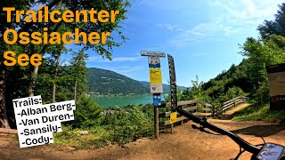
      Checking out Trailcenter Ossiacher See - lake.bike
      mtb
      10:49 | 189 | Jan 15, 2026 , Villach
      Cody Trail @lake.bike
      mtb
      0:59 | 521 | Sep 14, 2022 , Villach
      4.6 ★★★★★
      9 Ratings
      5 ★ 67%
      4 ★ 22%
      3 ★ 11%
      2 ★
      1 ★

      4 Reviews & Comments

      LukasK2
      perfect finish after a fun trail day - surfing big corners and perfect made tables and sharkfin while enjoying lake views
      provencemb provencemb
      perfect blue flow line, no break needed, easy and fun
      ktm-boy-69 ktm-boy-69
      Super Abschluss! Jede Kurve schön gebaut. Die Hupferln sind alles Tables und nix riesiges drinnen, aber machen Spaß – perfekt zum Ausrollen nach den Trails. Kann man sich schön nach vor tasten beim Hupfen.

      We hope you've been enjoying Trailforks!

      Create a FREE account to view all trail reviews and much more.

      • By lakebiketrailsTF Pro lakebike & contributors
      • #569310 - 949 views

      Frequently Asked Questions

      ▼ Where is CODY TRAIL located?
      CODY TRAIL is located in Trailcenter Ossiacher See, Villach, Austria. It is part of the Trailcenter Ossiacher See trail network. The trailhead is located at coordinates 46.66179, 13.97577.
      ▼ How hard is CODY TRAIL?
      CODY TRAIL is rated as Blue difficulty. The physical rating is Easy. The average grade is 6.6%.
      ▼ What is the elevation gain for CODY TRAIL?
      The trail has 84 ft of elevation descent. The elevation ranges from 1,692 ft to 1,777 ft.
      ▼ Is CODY TRAIL a point to point trail?
      Yes, CODY TRAIL is a point to point trail. The direction is One Direction. The trail type is singletrack.
      ▼ How long is CODY TRAIL?
      CODY TRAIL is 1,283 ft long. The trail type is singletrack.
      ▼ Are dogs allowed on CODY TRAIL?
      There is no information about dogs being allowed on CODY TRAIL. Check with local trail managers or the trail page for the latest access rules.
      ▼ When is the best time of year to ride CODY TRAIL?
      CODY TRAIL is best visited during: Mai till October.
      ▼ How do I access CODY TRAIL? Where is the closest parking trailhead?
      The closest parking and trailhead locations to CODY TRAIL are: View all parking locations in the area.
      ▼ How long does it take to ride CODY TRAIL?
      Based on recorded activities, it takes an average of 1 minute to ride CODY TRAIL. The trail is 1,283 ft long. Actual times will vary based on fitness level, conditions, and pace. View recent activity logs for more details.
      ▼ How busy is CODY TRAIL?
      CODY TRAIL is a very popular trail. There have been 452 recorded activities on this trail. The trail has received 835 check-ins. View recent activity on this trail.

      Hit the Trail

      Open in App

      Get this trail on your phone instantly.

      open trail in app

      Download Trail

      Save to wishlist, Garmin & download.
      save the trail

      Find Related Routes

      Find routes and users activities that include this trail.
      find routes for this trail

      You must enter a description before submitting.

