more stats
1.4 miles
Distance
138 ft
Climb
-1,617 ft
Descent
00:13:40
Avg time
-1,479 ft
Altitude change
806 ft
Altitude min
2,285 ft
Altitude max
2,285 ft
Altitude start
806 ft
Altitude end
-20.607%
Grade
-52.258%
Grade max
47.284%
Grade min
725 ft
Distance climb
1 mile
Distance down
172 ft
Distance flat
00:13:40
Avg time

Comét Details

  • Activities
    • Mountain Bike
    • E-Bike
  • Riding Area
    Alano
    Alano di Piave
  • Difficulty Rating
  • Local Popularity
    5 in Mountain Biking [+]
    • 5 in E-Biking
  • Global Ranking
    #44982 in Mountain Biking [+]
    • #102460 in E-Biking
  • Trail Type
    Singletrack
  • Bike Type
    DH, AM
  • Direction
    Downhill Only
    Popular Direction Shown
  • Physical Rating
    Hard
  • Trail Visibility
    Always easy to follow
  • Dogs Allowed
    Yes
  • eBike Allowed
    Yes up to Class 1

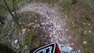
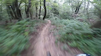
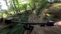
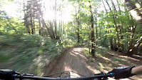
La prima parte è abbastanza flow su terra morbida, poi si passa alla parte centrale molto scassata e piena di rocce smosse, per poi tirare un po' il fiato nell'ultimo tratto, veloce e meno impegnativo. Sentiero super divertente ma assicuratevi di avere gomme molto resistenti
1/3 flowy hardpack, 2/3 steep,rocks, 3/3 fast and loose
Half intermediate, half difficult, be sure to have good tires, or Comét will slay them! This is one of the best trails in the area, be careful if wet.

Recent Activity on Trail

Past Week
  • 0 rides
  •  
6 Months
  • 0 rides
  •  
All
  • 4 rides
  • Last: Mar 21, 2025
c1c2c3c4
January
February
March
April
May
June
July
August
September
October
November
December
update trails status or condition

Comét Trail Reports

statusdatedescription
Mar 21, 2025 @ 4:22pm
Mar 21, 2025
Non so se è stato pulito o cosa, ma dopo gli ultimi schianti di riesce a percorrere meglio il sentiero. Iniziamo a formarsi sentieri attorno gli...
May 19, 2022 @ 9:15am
May 19, 2022
Uno schifo
Apr 14, 2022 @ 12:08pm
Apr 14, 2022
Un paio di alberi in mezzo ma facilmente superabili. Sentiero a posto
Nov 1, 2020 @ 7:52am
Nov 1, 2020
L'albero è ancora lì, il fondo è pieno di foglie, in generale percorribile ma non è al 100%
Sep 5, 2020 @ 11:14am
Sep 5, 2020
albero caduto nella prima parte "flow"
more »
Status:
on Mar 21, 2025
Dry
Avg: 4.08 (5 votes)
Your vote: 0

view (56)
close
3D
Trail Conditions
  • Unknown
  • Snow Groomed
  • Snow Packed
  • Snow Covered
  • Snow Cover Partial
  • Freeze/thaw Cycle
  • Icy
  • Prevalent Mud
  • Wet
  • Variable
  • Ideal
  • Dry
  • Very Dry
Trail Flow (Ridden Direction)
Trailforks scans users ridelogs to determine the most popular direction each trail is ridden. A good flowing trail network will have most trails flowing in a single direction according to their intension.
The colour categories are based on what percentage of riders are riding a trail in its intended direction.
  • > 96%
  • > 90%
  • > 80%
  • > 70%
  • > 50%
  • < 50%
  • bi-directional trail
  • no data
Trail Last Ridden
Trailforks scans ridelogs to determine the last time a trail was ridden.
  • < 2 days
  • < 1 week
  • < 2 weeks
  • < 1 month
  • < 6 months
  • > 6 months
Trail Ridden Direction
The intended direction a trail should be ridden.
  • Downhill Only
  • Downhill Primary
  • Both Directions
  • Uphill Primary
  • Uphill Only
  • One Direction
Contribute Details
Colors indicate trail is missing specified detail.
  • Description
  • Photos
  • Description & Photos
  • Videos
Trail Popularity ?
Trailforks scans ridelogs to determine which trails are ridden the most in the last 9 months. Trails are compared with nearby trails in the same city region with a possible 25 colour shades. Think of this as a heatmap, more rides = more kinetic energy = warmer colors.
  • most popular
  • popular
  • less popular
  • not popular
ATV/ORV/OHV Filter
Max Vehicle Width
inches
US Cell Coverage
Legend
cell carrier legend

Radar Time
Activity Recordings
Trailforks uses anonymized public activity data. ?
Activity Recordings
Trailforks uses anonymized public activity data. ?
Personal Heatmap
Activity Types
all / none
Options
2
Date range month
Winter Trails
Warning A routing network for winter maps does not exist. Selecting trails using the winter trails layer has been disabled.
Missing Trails
Most Popular
Least Popular
Trails are colored based on popularity. The more popular a trail is, the more red. Less popular trails trend towards green.
Jump Magnitude Heatmap
Heatmap of where riders jump on trails. Zoom in to see individual jumps, click circles to view jump details.
BC Backroad Status

Service Road Atlas is a free to use, community-driven service for viewing and creating reports on the numerous back-country service roads around B.C. and Alberta.

map legend
Slope Aspect
Direction the slope faces
Flat N NE E SE S SW W NW
Trails Deemphasized
Trails are shown in grey.
disable
Only show trails with no bike usage.
Enable
Suggested Layers
Based on selected activity type

    Save the current map location and zoom level as your default home location whenever this page is loaded.

    Save
        Directions to comet trailhead (45.891770, 11.923660)

        Photos

        82 more »
        64 |
        Apr 11, 2018 @ 12:48pm
        Apr 11, 2018
        57 |
        Apr 11, 2018 @ 12:48pm
        Apr 11, 2018
        53 |
        Apr 11, 2018 @ 12:47pm
        Apr 11, 2018
        87 |
        Apr 11, 2018 @ 12:44pm
        Apr 11, 2018

        Videos

        4 more »
        Discesa Monfenera (le Betulle) / Comét -...
        1116 | Aug 16, 2016 , Alano di Piave
        Comèt maintenance (funny)
        3:56 | 173 | Sep 27, 2017 , Alano di Piave
        Comét Uncut Full
        5:51 | 190 | Jun 13, 2017 , Alano di Piave
        Comét Highlights
        3:33 | 95 | Jun 12, 2017 , Alano di Piave

        Trail Lists

        Routes with this trail

        4 miles 543 ft 8 Loop
        Giro adatto ai meno allenati ma che permette comunque di attraversare dei bei scorci del paese.
        12 miles 3,384 ft 20 Loop
        Tracciato di media difficoltà e molto divertente

        8 Reviews & Comments


        We hope you've been enjoying Trailforks!

        Create a FREE account to view trail comments and much more.

        • By bafoTF Pro & contributors
        • #64882 - 4,313 views

        Frequently Asked Questions About Comét

        Where is Comét located?
        Comét is located in Alano, Alano di Piave, Italy. It is part of the Alano trail network. The trailhead is located at coordinates 45.89177, 11.92366.
        How hard is Comét?
        Comét is rated as Red difficulty. The physical rating is Hard. The average grade is 20.607%.
        What is the elevation gain for Comét?
        Comét has 138 ft of elevation gain. The trail has 1,617 ft of elevation descent. The elevation ranges from 806 ft to 2,285 ft.
        Is Comét a point to point trail?
        Yes, Comét is a point to point trail. The direction is Downhill Only. The trail type is singletrack.

        Hit the Trail

        Open in App

        Get this trail on your phone instantly.
        open trail in app

        Download Trail

        Save to wishlist, Garmin & download.
        save the trail

        Find Related Routes

        Find routes and users activities that include this trail.
        find routes for this trail

        You must enter a description before submitting.