more stats
1.0 mile
Distance
47 ft
Climb
-1,165 ft
Descent
00:16:10
Avg time
-1,118 ft
Altitude change
573 ft
Altitude min
1,692 ft
Altitude max
1,692 ft
Altitude start
574 ft
Altitude end
-20.4%
Grade
-110.2%
Grade max
14.8%
Grade min
735 ft
Distance climb
4,573 ft
Distance down
167 ft
Distance flat
00:16:10
Avg time

Corna Flow Details

  • Activities
    • Mountain Bike
    • Hike
    • Trail Running
  • Riding Area
  • Difficulty Rating
  • Voted Difficulty
    Black Diamond (1 vote)
  • Local Popularity
    90 in Mountain Biking [+]
    • 5 in Trail Running
    • 5 in Hiking
  • Global Ranking
    #28993 in Mountain Biking [+]
    • #127232 in Trail Running
    • #120430 in Hiking
  • Trail Type
    Singletrack
  • Bike Type
    DH, AM, XC
  • Direction
    Downhill Only
    Popular Direction Shown
  • Climb Difficulty
    Blue
  • Physical Rating
    Moderate
  • Trail Visibility
    Always easy to follow
  • Dogs Allowed
    Yes
  • eBike Allowed
    Yes up to Class 1

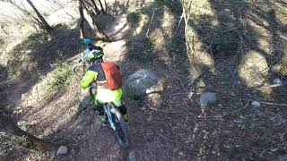
The first segment is quite fast, steep but with few rocks.
Keep right at the fork and go down (update feb 2020 - wooden steps appeared magically overnight, no more the 10, ride on).
After a short almost flat connection, the trail restart descending with a fast and flowy section with the only obstacle represented by a steep chute no longer more than a couple of meters (no that easy for beginners but there is a chicken line on the left doable by foot only). Keep your eyes open at the gravel road, after the short flat part you have to re enter in the woods on your left for the last part, smooth but with switchbacks and a final small rocky step down (doable by foot if needed).

Lots of hikers on good days all year long. Peace.

Disclaimer

First and last parts sits on private land. Respect it.

Recent Activity on Trail

Past Week
  • 0 rides
  •  
6 Months
  • 7 rides
  • 13 miles avg distance
All
  • 74 rides
  • Last: May 22, 2026
c1c2c3c4
January
February
March
April
May
June
July
August
September
October
November
December
update trails status or condition

Corna Flow Trail Reports

statusdatedescription
Jun 10, 2025 @ 8:14am
Jun 10, 2025
May 21, 2025 @ 12:05pm
May 21, 2025
E' cresciuta un po' di vegetazione...
Apr 1, 2025 @ 3:38pm
Apr 1, 2025
When it is very dry, Corna becomes a little bit slippery, then it depends on the rider...
Jun 28, 2024 @ 11:49pm
Jun 28, 2024
Serious water damage, I do not recommend the trail before some work has be done.
Feb 5, 2024 @ 1:05am
Feb 5, 2024
more »
Status:
on Jun 10, 2025
Dry
Avg: 4.68 (13 votes)
Your vote: 0

view (317)
close
3D
Trail Conditions
  • Unknown
  • Snow Groomed
  • Snow Packed
  • Snow Covered
  • Snow Cover Partial
  • Freeze/thaw Cycle
  • Icy
  • Prevalent Mud
  • Wet
  • Variable
  • Ideal
  • Dry
  • Very Dry
Trail Flow (Ridden Direction)
Trailforks scans users ridelogs to determine the most popular direction each trail is ridden. A good flowing trail network will have most trails flowing in a single direction according to their intension.
The colour categories are based on what percentage of riders are riding a trail in its intended direction.
  • > 96%
  • > 90%
  • > 80%
  • > 70%
  • > 50%
  • < 50%
  • bi-directional trail
  • no data
Trail Last Ridden
Trailforks scans ridelogs to determine the last time a trail was ridden.
  • < 2 days
  • < 1 week
  • < 2 weeks
  • < 1 month
  • < 6 months
  • > 6 months
Trail Ridden Direction
The intended direction a trail should be ridden.
  • Downhill Only
  • Downhill Primary
  • Both Directions
  • Uphill Primary
  • Uphill Only
  • One Direction
Contribute Details
Colors indicate trail is missing specified detail.
  • Description
  • Photos
  • Description & Photos
  • Videos
Trail Popularity ?
Trailforks scans ridelogs to determine which trails are ridden the most in the last 9 months. Trails are compared with nearby trails in the same city region with a possible 25 colour shades. Think of this as a heatmap, more rides = more kinetic energy = warmer colors.
  • most popular
  • popular
  • less popular
  • not popular
ATV/ORV/OHV Filter
Max Vehicle Width
inches
US Cell Coverage
Legend
cell carrier legend

Radar Time
Activity Recordings
Trailforks uses anonymized public activity data. ?
Activity Recordings
Trailforks uses anonymized public activity data. ?
Personal Heatmap
Activity Types
all / none
Options
2
Date range month
Winter Trails
Warning A routing network for winter maps does not exist. Selecting trails using the winter trails layer has been disabled.
Missing Trails
Most Popular
Least Popular
Trails are colored based on popularity. The more popular a trail is, the more red. Less popular trails trend towards green.
Jump Magnitude Heatmap
Heatmap of where riders jump on trails. Zoom in to see individual jumps, click circles to view jump details.
BC Backroad Status

Service Road Atlas is a free to use, community-driven service for viewing and creating reports on the numerous back-country service roads around B.C. and Alberta.

map legend
Slope Aspect
Direction the slope faces
Flat N NE E SE S SW W NW
Trails Deemphasized
Trails are shown in grey.
disable
Only show trails with no bike usage.
Enable
Suggested Layers
Based on selected activity type

    Save the current map location and zoom level as your default home location whenever this page is loaded.

    Save
        Directions to corna-flow trailhead (45.617370, 10.524350)

        Photos

        10 more »
        63 |
        Sep 1, 2024 @ 7:48am
        Sep 1, 2024
        63 |
        Sep 1, 2024 @ 7:48am
        Sep 1, 2024
        51 |
        Sep 1, 2024 @ 7:47am
        Sep 1, 2024
        73 |
        Sep 1, 2024 @ 7:47am
        Sep 1, 2024

        Videos

        1 more »
        Corna Flow, Salò
        7:40 | 437 | May 2, 2023 , Salò

        6 Reviews & Comments


        We hope you've been enjoying Trailforks!

        Create a FREE account to view trail comments and much more.

        • By Coach86TF Pro & contributors
        • #178920 - 2,204 views

        Frequently Asked Questions About Corna Flow

        Where is Corna Flow located?
        Corna Flow is located in Corna di Salò, Salò, Italy. It is part of the Corna di Salò trail network. The trailhead is located at coordinates 45.61737, 10.52435.
        How hard is Corna Flow?
        Corna Flow is rated as Blue difficulty. The physical rating is Moderate. The average grade is 20.4%. The climb difficulty is rated Blue.
        What is the elevation gain for Corna Flow?
        Corna Flow has 47 ft of elevation gain. The trail has 1,165 ft of elevation descent. The elevation ranges from 573 ft to 1,692 ft.
        Is Corna Flow a point to point trail?
        Yes, Corna Flow is a point to point trail. The direction is Downhill Only. The trail type is singletrack.

        Hit the Trail

        Open in App

        Get this trail on your phone instantly.
        open trail in app

        Download Trail

        Save to wishlist, Garmin & download.
        save the trail

        Find Related Routes

        Find routes and users activities that include this trail.
        find routes for this trail

        You must enter a description before submitting.