Coronet Loop Details
-
Activities
- Mountain Bike
- E-Bike
- Hike
- Trail Running
-
Riding Area
-
Difficulty Rating
-
Hiking SAC ScaleT1 Hiking
-
Trail TypeSingletrack
-
Bike TypeAM, XC
-
DirectionBoth DirectionsPopular direction shown
-
Climb DifficultyBlue
-
Physical RatingHard
-
Trail VisibilityAlways easy to follow
-
SeasonOct - May
-
Dogs AllowedYes
-
eBike AllowedYes up to Class 1
-
Year Opened2022
-
Land OwnerSoho Properties Ltd
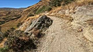
Starting in Arrowtown, the Coronet Loop can be ridden in both directions but preference is clockwise. Start by climbing the Bush Creek Trail and traversing the Coronet Face Water Race towards Skippers Saddle. Thrill seekers should take a diversion down Hot Rod and climb back up Dan O'Connell track before heading up over Tradesmans and into Pack Track and Sack (grade 4). This section can be bypassed on the original Pack Track or Skippers Road. Climb out of Long Gully into Greengate and Deep Creeks on sections of historic pack track, before descending Eight Mile Creek on an old water race back to the Macetown Road. Follow the signs along the old benched miners trail to keep your feet dry, and finish on the Arrow Gorge Trail or via the Macetown Road if you don't mind getting wet. Total loop is approx 50km of epic backcountry terrain.
Local Trail Association
-
Please consider joining or donating to the local trail association to supportdonate to earn trail karma!
trail development & maintenance.
More Stats for Coronet Loop mountain bike trail trail
-
Altitude change167 ft
-
Altitude min1,874 ft
-
Altitude max2,887 ft
-
Altitude start1,916 ft
-
Altitude end2,083 ft
-
Grade0.2%
-
Grade max-83.6%
-
Grade min61.9%
-
Distance climb7 miles
-
Distance down7 miles
-
Distance flat4,409 ft
-
Avg time03:19:38
-
Avg reverse time02:28:43
- view trail stats
- Unknown
- Snow Groomed
- Snow Packed
- Snow Covered
- Snow Cover Partial
- Freeze/thaw Cycle
- Icy
- Prevalent Mud
- Wet
- Variable
- Ideal
- Dry
- Very Dry
The colour categories are based on what percentage of riders are riding a trail in its intended direction.
- > 96%
- > 90%
- > 80%
- > 70%
- > 50%
- < 50%
- bi-directional trail
- no data
- < 2 days
- < 1 week
- < 2 weeks
- < 1 month
- < 6 months
- > 6 months
- Downhill Only
- Downhill Primary
- Both Directions
- Uphill Primary
- Uphill Only
- One Direction
- Description
- Photos
- Description & Photos
- Videos
- most popular
- popular
- less popular
- not popular
- mountain biking recent
- mountain biking (>6 month)
- hiking (1 year)
- moto (1 year)
- Downhill Ski
- Backcountry Ski
- Nordic Ski
- Snowmobile
Save the current map location and zoom level as your default home location whenever this page is loaded.
SaveCoronet Loop Trail Reports
Recent Ridelog Activity on Trail
- 0 rides
- 2 rides
- 36 miles avg distance
- 9 rides
- Last: Apr 25, 2025
Photos
Links
6 Reviews & Comments
We hope you've been enjoying Trailforks!
Create a FREE account to view trail comments and much more.
Videos

Nearby Trails
- Skippers Road 1,512 ft
- Pack Track - Coronet Loop Link 1,693 ft
- Greengates Pack Track 3,694 ft
- Atley Tarrace Track 3 miles
- Dewar To Atley Terrace 3 miles
- By QTWilly
& contributors
- #516623 - 5,008 views
- follow/subscribe
- login to download gpx or kml files.
You must enter a description before submitting.