CPR Trail Details
-
Activities
- Hike
- Trail Running
-
Riding AreaMount Arrowsmith Regional Park
Port Alberni, British Columbia -
Difficulty Rating
-
Hiking SAC ScaleT3 Demanding Mountain Hiking
-
Trail TypeSingletrack
-
DirectionBoth Directions
-
Physical RatingModerate
-
Trail VisibilityAlways easy to follow
-
Alpine TrailYes
-
eBike Allowed
-
Global Ranking
-
Local Popularity100 in Hiking [+]
- 95 in Trail Running
-
OSM Way
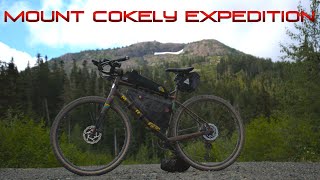
Situated on private forest lands under licence to the RDN, the trail winds up from Highway 4A through deep woods, develops into a loop, and finishes at an old ski hill below Mt Cokely. It's a good four-hour climb with 1,000 metres in elevation gain on rough but ready trail. The views from the forested mountain trail are spectacular, and there is a great lookout halfway up. It's high country so be prepared: pack water, warm clothing and wear sturdy boots.
Access Info
Parking is alongside highway 4 across from Cameron Lake.
Traditionally Indigenous Territory
More Stats for CPR Trail hike trail trail
-
Altitude change3,107 ft
-
Altitude min658 ft
-
Altitude max3,766 ft
-
Altitude start658 ft
-
Altitude end3,766 ft
-
Grade12.6%
-
Grade max-22.8%
-
Grade min73.1%
-
Distance climb4 miles
-
Distance down3,789 ft
-
Distance flat1,427 ft
-
Avg time01:03:06
- view trail stats
- Unknown
- Snow Groomed
- Snow Packed
- Snow Covered
- Snow Cover Partial
- Freeze/thaw Cycle
- Icy
- Prevalent Mud
- Wet
- Variable
- Ideal
- Dry
- Very Dry
The colour categories are based on what percentage of riders are riding a trail in its intended direction.
- > 96%
- > 90%
- > 80%
- > 70%
- > 50%
- < 50%
- bi-directional trail
- no data
- < 2 days
- < 1 week
- < 2 weeks
- < 1 month
- < 6 months
- > 6 months
- Downhill Only
- Downhill Primary
- Both Directions
- Uphill Primary
- Uphill Only
- One Direction
- Description
- Photos
- Description & Photos
- Videos
- most popular
- popular
- less popular
- not popular
- mountain biking recent
- mountain biking (>6 month)
- hiking (1 year)
- moto (1 year)
- Downhill Ski
- Backcountry Ski
- Nordic Ski
- Snowmobile
Save the current map location and zoom level as your default home location whenever this page is loaded.
SaveCPR Trail Trail Reports
Recent Ridelog Activity on Trail
- 0 rides
- 2 rides
- 8 miles avg distance
- 16 rides
Photos
Reviews / Comments
No reviews yet, be the first to write a review or ask a question.
Use trail reports to comment on trail conditions.
We hope you've been enjoying Trailforks!
Create a FREE account to view trail comments and much more.
Videos

Nearby Trails
- Wesley Ridge 2,667 ft
- Cpr Lookout Trail 2 miles
- Cpr Lookout Cokley Connector 2 miles
- Connector 2 miles
- Deactivated 3 miles
Mount Arrowsmith Regional Park
- By canadaka
Trailforks & contributors
- #276436 - 1,682 views
You must enter a description before submitting.