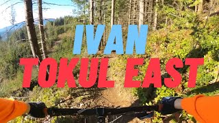
1,742 ft
Distance
-230 ft
Descent
00:02:29
Avg time

Crazy Ivan Details

  • Activities
    • Mountain Bike
    • Hike
    • Trail Running
  • Riding Area
    Tokul East
    Fall City, Washington
  • Difficulty Rating
  • Voted Difficulty
    Blue (4 votes)
  • Trail Type
    Singletrack
  • Direction
    Downhill Primary
    Popular direction shown
  • Dogs Allowed
    Yes
  • eBike Allowed
  • Global Ranking
    #1363 in Mountain Biking [+]
    • #42082 in Trail Running
    • #8607 in Hiking
  • Local Popularity
    95 in Mountain Biking [+]
    • 5 in Trail Running
    • 100 in Hiking
  • Land Owner
    Campbell Global

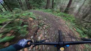
Lower Crazy Ivan is a super fun and fast flow trail. It includes an optional natural stump jump, several small optional jumps, one mandatory but rollable drop, a steep techie section, and nice berms. It is a must ride trail at Tokul East.

Access Info

Note: a Hancock Forest Recreation Pass (click on Land Manager link) is required to ride the Tokul East and Tokul West trails.

At the bottom of Crazy Ivan - Upper Section, shift to low gear quickly before exiting the trail, then climb the steep road to the left for 100 feet or so. The entrance to Lower Crazy Ivan is on your right.

Alternatively, Lower Crazy Ivan can be reached from Midtown two ways: 1) either by riding upper Midtown, then going right on the road downhill, skipping the first junction (which goes up a steep road to Upper Crazy Ivan and KGB), then taking a right at the next road junction. The trail entrance is a half mile or so down on the left side, and clearly marked. Or 2) by riding the middle section of Midtown, then head back up to the right on the road, switchback uphill, and then take the first road to the left. Go 1/2 mi or so, and the entrance is on your left, clearly marked.

Disclaimer

Riding this trail requires a permit from Campbell Global! Don't threaten this trail being closed by not having a permit.

Traditionally Indigenous Territory
More Stats for Crazy Ivan mountain bike trail trail
  • Altitude change
    -230 ft
  • Altitude min
    385 ft
  • Altitude max
    615 ft
  • Altitude start
    615 ft
  • Altitude end
    384 ft
  • Grade
    -13.2%
  • Grade max
    -37%
  • Grade min
    -1.5%
  • Distance down
    1,742 ft
  • Avg time
    00:02:29
  • Avg reverse time
    00:20:10
  • view trail stats
Status:
on Feb 18, 2025
Wet
Avg: 4.55 (49 votes)
Your vote: 0

view (8,522)
close
3D
Trail Conditions
  • Unknown
  • Snow Groomed
  • Snow Packed
  • Snow Covered
  • Snow Cover Partial
  • Freeze/thaw Cycle
  • Icy
  • Prevalent Mud
  • Wet
  • Variable
  • Ideal
  • Dry
  • Very Dry
Trail Flow (Ridden Direction)
Trailforks scans users ridelogs to determine the most popular direction each trail is ridden. A good flowing trail network will have most trails flowing in a single direction according to their intension.
The colour categories are based on what percentage of riders are riding a trail in its intended direction.
  • > 96%
  • > 90%
  • > 80%
  • > 70%
  • > 50%
  • < 50%
  • bi-directional trail
  • no data
Trail Last Ridden
Trailforks scans ridelogs to determine the last time a trail was ridden.
  • < 2 days
  • < 1 week
  • < 2 weeks
  • < 1 month
  • < 6 months
  • > 6 months
Trail Ridden Direction
The intended direction a trail should be ridden.
  • Downhill Only
  • Downhill Primary
  • Both Directions
  • Uphill Primary
  • Uphill Only
  • One Direction
Contribute Details
Colors indicate trail is missing specified detail.
  • Description
  • Photos
  • Description & Photos
  • Videos
Trail Popularity ?
Trailforks scans ridelogs to determine which trails are ridden the most in the last 9 months. Trails are compared with nearby trails in the same city region with a possible 25 colour shades. Think of this as a heatmap, more rides = more kinetic energy = warmer colors.
  • most popular
  • popular
  • less popular
  • not popular
ATV/ORV/OHV Filter
Max Vehicle Width
inches
US Cell Coverage
Legend
cell carrier legend

Radar Time
x Activity Recordings
Trailforks users anonymized public ridelogs from the past 6 months.
  • mountain biking recent
  • mountain biking (>6 month)
  • hiking (1 year)
  • moto (1 year)
Activity Recordings
Trailforks users anonymized public skilogs from the past 12 months.
  • Downhill Ski
  • Backcountry Ski
  • Nordic Ski
  • Snowmobile
Winter Trails
Warning A routing network for winter maps does not exist. Selecting trails using the winter trails layer has been disabled.
x Missing Trails
Most Popular
Least Popular
Trails are colored based on popularity. The more popular a trail is, the more red. Less popular trails trend towards green.
Jump Magnitude Heatmap
Heatmap of where riders jump on trails. Zoom in to see individual jumps, click circles to view jump details.
Trails Deemphasized
Trails are shown in grey.
disable
Only show trails with NO bikes.
enable

Save the current map location and zoom level as your default home location whenever this page is loaded.

Save
      Directions to crazy-ivan trailhead (47.569010, -121.860310)
      update trails status or condition

      Crazy Ivan Trail Reports

      statusdatedescription
      Feb 18, 2025 @ 9:15pm
      Feb 18, 2025
      Until further notice. There is an unresolved permitting issue between the landowner and King County. Please Follow Tokuls only on Facebook for...
      Feb 18, 2025 @ 9:13pm
      Feb 18, 2025
      further notice. There is an unresolved permitting issue between the landowner and King County. Please Follow Tokuls only on Facebook for updates.
      Jan 13, 2025 @ 11:13pm
      Jan 13, 2025
      Trail was good today.
      Dec 8, 2024 @ 1:32pm
      Dec 8, 2024
      Nov 27, 2024 @ 3:39pm
      Nov 27, 2024
      view all reports »

      Recent Ridelog Activity on Trail

      Past Week
      • 0 rides
      •  
      6 Months
      • 14 rides
      • 12 miles avg distance
      All
      • 979 rides
      • Last: Jun 10, 2025

      Photos

      more »
      234 |
      Jun 20, 2021 @ 3:01pm
      Jun 20, 2021
      229 |
      Apr 15, 2021 @ 9:55pm
      Apr 15, 2021
      315 |
      Oct 5, 2020 @ 9:29pm
      Oct 5, 2020
      422 |
      Apr 20, 2019 @ 11:53am
      Apr 20, 2019

      Routes with this trail

      more »
      titledistance
      East Tukol Morning Shred6 miles
      tokul_east_loop8 miles
      First timer Tokul route8 miles
      Black Diamond Trails at Tokul29 miles

      5 Reviews & Comments


      We hope you've been enjoying Trailforks!

      Create a FREE account to view trail comments and much more.

      Videos

      more »
      Crazy Ivan at Tokul East
      2:09 | 359 | Dec 28, 2022 , Fall City
      Crazy Ivan - Tokul East 2019 [4K]
      3:21 | 307 | May 15, 2022 , Fall City
      Lower Crazy Ivan| Tokul East| Fall City, WA |...
      2:29 | 252 | Mar 31, 2022 , Fall City
      Ivan trail at Tokul East MTB
      9:52 | 382 | Dec 9, 2020 , Fall City
      • By jebikeTF Pro & contributors
      • #17234 - 9,344 views

      You must enter a description before submitting.