Supporters, Builders, Maintainers & Land Managers of Crestline Trail
USFSLand Manager
Crestline Details
-
Activities
- Mountain Bike
- E-Bike
- Horse
- Hike
- Trail Running
- Dirtbike/Moto
-
Riding AreaScout Mountain
Pocatello, Idaho -
Difficulty Rating
-
Trail TypeSingletrack
-
Bike TypeAM
-
DirectionDownhill PrimaryPopular direction shown
-
Climb DifficultyDouble Black Diamond
-
Dogs AllowedYes
-
eBike AllowedYes up to Class 1
-
TTFs on TrailRock Garden
-
Global Ranking
-
Local Popularity55 in Mountain Biking [+]
- 70 in E-Biking
- 55 in Trail Running
- 55 in Hiking
- 5 in Dirtbiking
- 5 in Horseback
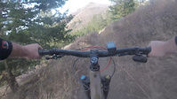
Uphill -- not good. Several long sections that are too steep and loose to pedal. I hiked probably 40%. The steeper the section, the looser it got. The views made it fun, but I'd never do it again. Better to shuttle the pavement up, and pedal the double track.
Downhill -- a high speed romp through the alpine meadows up top and the bottom half is like the Forest Moon of Endor. Definitely NOT a black diamond, but the loose conditions give it a dark blue, for sure. Leave your XC tires at home. This is Minion country.
Local Trail Association
-
Please consider joining or donating to the local trail association to supportdonate to earn trail karma!
trail development & maintenance.
Traditionally Indigenous Territory
More Stats for Crestline multi-use trail trail
-
Altitude change-2,299 ft
-
Altitude min5,742 ft
-
Altitude max8,107 ft
-
Altitude start8,041 ft
-
Altitude end5,741 ft
-
Grade-7.6%
-
Grade max-57.1%
-
Grade min23.1%
-
Distance climb3,409 ft
-
Distance down5 miles
-
Distance flat558 ft
-
Avg time00:42:06
-
Avg reverse time00:25:49
- view trail stats
- Unknown
- Snow Groomed
- Snow Packed
- Snow Covered
- Snow Cover Partial
- Freeze/thaw Cycle
- Icy
- Prevalent Mud
- Wet
- Variable
- Ideal
- Dry
- Very Dry
The colour categories are based on what percentage of riders are riding a trail in its intended direction.
- > 96%
- > 90%
- > 80%
- > 70%
- > 50%
- < 50%
- bi-directional trail
- no data
- < 2 days
- < 1 week
- < 2 weeks
- < 1 month
- < 6 months
- > 6 months
- Downhill Only
- Downhill Primary
- Both Directions
- Uphill Primary
- Uphill Only
- One Direction
- Description
- Photos
- Description & Photos
- Videos
- most popular
- popular
- less popular
- not popular
- mountain biking recent
- mountain biking (>6 month)
- hiking (1 year)
- moto (1 year)
- Downhill Ski
- Backcountry Ski
- Nordic Ski
- Snowmobile
Save the current map location and zoom level as your default home location whenever this page is loaded.
SaveCrestline Trail Reports
Recent Ridelog Activity on Trail
- 0 rides
- 3 rides
- 23.5 km avg distance
- 36 rides
- Last: Jul 11, 2025
Photos
Routes with this trail
5 Reviews & Comments
We hope you've been enjoying Trailforks!
Create a FREE account to view trail comments and much more.
Videos

Nearby Trails
- Mink To Box 2 miles
- Box Connector 3 miles
- Old Box Canyon Rd Connector 3 miles
- Goodenough Trail 4 miles
- Green Road 4 miles
- By todd
Trailforks & contributors
- #14229 - 5,086 views
- follow/subscribe
- login to download gpx or kml files.
You must enter a description before submitting.