more stats
2,297 ft
Distance
8 ft
Climb
-254 ft
Descent
00:10:41
Avg time
-246 ft
Altitude change
3,359 ft
Altitude min
3,605 ft
Altitude max
3,605 ft
Altitude start
3,359 ft
Altitude end
-10.705%
Grade
-39.502%
Grade max
8.314%
Grade min
162 ft
Distance climb
1,923 ft
Distance down
212 ft
Distance flat
00:10:41
Avg time

Crevice Details

  • Activities
    • Mountain Bike
    • Hike
    • Trail Running
  • Riding Area
    Crane Mountain Trails
    Bigfork, Montana
  • Difficulty Rating
  • Local Popularity
    5 in Mountain Biking [+]
    • 5 in Trail Running
    • 5 in Hiking
  • Global Ranking
    #113847 in Mountain Biking [+]
    • #268302 in Trail Running
    • #285736 in Hiking
  • Trail Type
    Singletrack
  • Bike Type
    DH
  • Direction
    Downhill Primary
    Popular Direction Shown
  • Dogs Allowed
    Yes
  • Year Opened
    2009

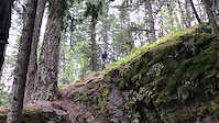
The challenge in this trail comes as a feature that brings you down a cliff through a crevice.

Access Info

Access by the middle access road, across from the exit of Original Sin. Note: In spring it is necessary to bypass the top of the trail due to soft ground. Take the next trail down (Tinkerbell) to the bypass.

This trail is unsanctioned.

Trail Supporters

  • USFS
    Land Manager
Traditionally Indigenous Territory

Recent Activity on Trail

Past Week
  • 0 rides
  •  
6 Months
  • 0 rides
  •  
All
  • 17 rides
  • Last: Oct 5, 2024
c1c2c3c4
January
February
March
April
May
June
July
August
September
October
November
December
update trails status or condition

Crevice Trail Reports

statusdatedescription
Oct 1, 2023 @ 1:48pm
Oct 1, 2023
Medium tree down across trail, blocking trail. Running a little wet
May 14, 2023 @ 4:01pm
May 14, 2023
Cleared
Aug 13, 2022 @ 3:15pm
Aug 13, 2022
Ideal
Jul 19, 2021 @ 4:30pm
Jul 19, 2021
Fun little guy, didn’t make the crevasse
Jun 18, 2020 @ 3:37pm
Jun 18, 2020
A couple trees down
more »
Status:
on Oct 1, 2023
Ideal
Avg: 4.09 (4 votes)
Your vote: 0

view (115)
close
3D
Trail Conditions
  • Unknown
  • Snow Groomed
  • Snow Packed
  • Snow Covered
  • Snow Cover Partial
  • Freeze/thaw Cycle
  • Icy
  • Prevalent Mud
  • Wet
  • Variable
  • Ideal
  • Dry
  • Very Dry
Trail Flow (Ridden Direction)
Trailforks scans users ridelogs to determine the most popular direction each trail is ridden. A good flowing trail network will have most trails flowing in a single direction according to their intension.
The colour categories are based on what percentage of riders are riding a trail in its intended direction.
  • > 96%
  • > 90%
  • > 80%
  • > 70%
  • > 50%
  • < 50%
  • bi-directional trail
  • no data
Trail Last Ridden
Trailforks scans ridelogs to determine the last time a trail was ridden.
  • < 2 days
  • < 1 week
  • < 2 weeks
  • < 1 month
  • < 6 months
  • > 6 months
Trail Ridden Direction
The intended direction a trail should be ridden.
  • Downhill Only
  • Downhill Primary
  • Both Directions
  • Uphill Primary
  • Uphill Only
  • One Direction
Contribute Details
Colors indicate trail is missing specified detail.
  • Description
  • Photos
  • Description & Photos
  • Videos
Trail Popularity ?
Trailforks scans ridelogs to determine which trails are ridden the most in the last 9 months. Trails are compared with nearby trails in the same city region with a possible 25 colour shades. Think of this as a heatmap, more rides = more kinetic energy = warmer colors.
  • most popular
  • popular
  • less popular
  • not popular
ATV/ORV/OHV Filter
Max Vehicle Width
inches
US Cell Coverage
Legend
cell carrier legend

Radar Time
Activity Recordings
Trailforks uses anonymized public activity data. ?
Activity Recordings
Trailforks uses anonymized public activity data. ?
Personal Heatmap
Activity Types
all / none
Options
2
Date range month
Winter Trails
Warning A routing network for winter maps does not exist. Selecting trails using the winter trails layer has been disabled.
Missing Trails
Most Popular
Least Popular
Trails are colored based on popularity. The more popular a trail is, the more red. Less popular trails trend towards green.
Jump Magnitude Heatmap
Heatmap of where riders jump on trails. Zoom in to see individual jumps, click circles to view jump details.
BC Backroad Status

Service Road Atlas is a free to use, community-driven service for viewing and creating reports on the numerous back-country service roads around B.C. and Alberta.

map legend
Slope Aspect
Direction the slope faces
Flat N NE E SE S SW W NW
Trails Deemphasized
Trails are shown in grey.
disable
Only show trails with no bike usage.
Enable
Suggested Layers
Based on selected activity type

    Save the current map location and zoom level as your default home location whenever this page is loaded.

    Save
        Directions to crevice trailhead (48.011638, -114.015985)

        Photos

        2 more »
        470 |
        Mar 3, 2013 @ 12:01pm
        Mar 3, 2013
        366 |
        Mar 3, 2013 @ 12:15pm
        Mar 3, 2013

        Videos

        3 more »
        Crevice Trail
        0:12 | | May 16, 2025 , Bigfork
        Bigfork, MT
        0:12 | 33 | May 16, 2025 , Bigfork
        Crevice
        0:12 | | May 16, 2025 , Bigfork

        3 Reviews & Comments


        We hope you've been enjoying Trailforks!

        Create a FREE account to view trail comments and much more.

        • #21107 - 2,183 views

        Frequently Asked Questions About Crevice

        Where is Crevice located?
        Crevice is located in Crane Mountain Trails, Bigfork, Montana, United States. It is part of the Crane Mountain Trails trail network. The trailhead is located at coordinates 48.01164, -114.01599.
        How hard is Crevice?
        Crevice is rated as Black Diamond difficulty. The average grade is 10.705%.
        What is the elevation gain for Crevice?
        Crevice has 2 m of elevation gain. The trail has 77 m of elevation descent. The elevation ranges from 1,024 m to 1,099 m.
        Is Crevice a point to point trail?
        Crevice is not a point to point trail. The direction is Downhill Primary. The trail type is singletrack.

        Hit the Trail

        Open in App

        Get this trail on your phone instantly.
        open trail in app

        Download Trail

        Save to wishlist, Garmin & download.
        save the trail

        Find Related Routes

        Find routes and users activities that include this trail.
        find routes for this trail

        You must enter a description before submitting.