
more stats
4,652 ft
Distance
-709 ft
Descent
00:14:33
Avg time
-709 ft
Altitude change
1,213 ft
Altitude min
1,923 ft
Altitude max
1,923 ft
Altitude start
1,214 ft
Altitude end
-15.2%
Grade
-43.6%
Grade max
4,265 ft
Distance down
387 ft
Distance flat
00:14:33
Avg time

Czart Details

  • Activities
    • Mountain Bike
    • E-Bike
  • Riding Area
    Masyw Ślęży
    Sobótka
  • Difficulty Rating
  • Voted Difficulty
    Red (2 votes)
  • Local Popularity
    95 in Mountain Biking [+]
    • 95 in E-Biking
  • Global Ranking
    #374 in Mountain Biking [+]
    • #11754 in E-Biking
  • National Ranking
    #7 in Mountain Biking · Poland [+]
    • #232 in E-Biking
  • Trail Type
    Singletrack
  • Bike Type
    AM
  • Direction
    Downhill Only[+]
    Popular Direction Shown
    • Downhill Only for E-Biking
  • Dogs Allowed
    Yes
  • eBike Allowed
    Yes up to Class 1
  • TTFs on Trail
    A-Frame, Berm, Bridge, Drop, Jump, Gap Jump, Rock Garden
  • Lighting
    No

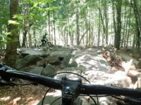
Nowa, ultra kamienista w górnej sekcji, trasa.

This trail is unsanctioned.

Trail Supporters

Recent Activity on Trail

Past Week
  • 0 rides
  •  
6 Months
  • 41 rides
  • 13 miles avg distance
All
  • 97 rides
  • Last: Oct 24, 2026
c1c2c3c4
January
February
March
April
May
June
July
August
September
October
November
December
Status:
on Sep 13, 2026
Ideal
Avg: 4.49 (6 votes)
Your vote: 0

view (575)
close
      Directions to czart trailhead (50.870570, 16.716940)

      Photos

      8 more »
      report
      mtb
      71 |
      Nov 1, 2025 @ 4:11pm
      Nov 1, 2025
      report
      mtb
      67 |
      Nov 1, 2025 @ 4:11pm
      Nov 1, 2025
      report
      mtb
      70 |
      Nov 1, 2025 @ 4:11pm
      Nov 1, 2025
      report
      mtb
      75 |
      Nov 1, 2025 @ 4:11pm
      Nov 1, 2025

      Videos

      1 more »
      Czart - nowa trasa MTB na Ślęży - jak na...
      mtb
      458 | Jun 22, 2025 , Sobótka
      5.0 ★★★★★
      6 Ratings
      5 ★ 100%
      4 ★
      3 ★
      2 ★
      1 ★

      3 Reviews & Comments

      r85 r85
      Majstersztyk! Po prostu ręce same składają się do oklasków Big Grin Trasa kamienista, ale niesamowicie płynna przy tym! To jest zasługa tego, że tu jest kapitalnie wszystko wycyrklowane. Największy efekt wow jest oczywiście na tym najdłuższym na trasie i w całym ślężańskim masywie imponującym rockgardenie. Czegoś takiego jeszcze tu nie było. Jechałem to z rozdziawioną z zachwytu gębą i myślą w głowie - jak? no jak oni to do diabła zrobili? Absolutna petarda, wielki podziw i szacunek za pomysł i realizację, za ten ogrom pracy, który ewidentnie musiał zostać tu włożony. To jest aktualnie najlepsza rzecz na Ślęży i poprzeczka została zawieszona tak wysoko, że trudno to będzie przebić, ale nie przestawajcie! Big Grin Dla mnie trasa roku 2025. Fenomenalna.
      ArektIwkt
      Rewelacyjna trasa, masę włożonej pracy ale efekt jest powalający!! Wielkie dzięki dla budowniczych!!

      We hope you've been enjoying Trailforks!

      Create a FREE account to view all trail reviews and much more.

      • #848576 - 1,567 views

      Frequently Asked Questions

      ▼ Where is Czart located?
      Czart is located in Masyw Ślęży, Sobótka, Poland. It is part of the Masyw Ślęży trail network. The trailhead is located at coordinates 50.87057, 16.71694.
      ▼ How hard is Czart?
      Czart is rated as Red difficulty. The average grade is 15.2%.
      ▼ What is the elevation gain for Czart?
      The trail has 709 ft of elevation descent. The elevation ranges from 1,213 ft to 1,923 ft.
      ▼ Is Czart a point to point trail?
      Yes, Czart is a point to point trail. The direction is Downhill Only. The trail type is singletrack.
      ▼ How long is Czart?
      Czart is 4,652 ft long. The trail type is singletrack.
      ▼ Are dogs allowed on Czart?
      Yes, dogs are allowed on Czart. Please keep dogs on a leash where required and clean up after them.
      ▼ When is the best time of year to ride Czart?
      Based on activity log data, the most popular months to ride Czart are:
      • September (18 activities)
      • August (13 activities)
      • July (12 activities)
      Check the reports page for current trail conditions.
      ▼ How do I access Czart? Where is the closest parking trailhead?
      The closest parking and trailhead locations to Czart are: View all parking locations in the area.
      ▼ How long does it take to ride Czart?
      Based on recorded activities, it takes an average of 15 minutes to ride Czart. The trail is 4,652 ft long. Actual times will vary based on fitness level, conditions, and pace. View recent activity logs for more details.
      ▼ How busy is Czart?
      Czart is a very popular trail. There have been 531 recorded activities on this trail. The trail has received 575 check-ins. View recent activity on this trail.

      Hit the Trail

      Open in App

      Get this trail on your phone instantly.

      open trail in app

      Download Trail

      Save to wishlist, Garmin & download.
      save the trail

      Find Related Routes

      Find routes and users activities that include this trail.
      find routes for this trail

      You must enter a description before submitting.

